Tennessee State Route 25
State Route 25 (SR 25) is a 67.45-mile-long (108.55 km) east–west state highway in northern Middle Tennessee.[2]
| ||||
|---|---|---|---|---|
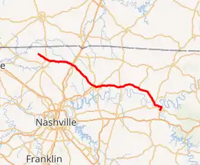
SR 25 highlighted in red | ||||
| Route information | ||||
| Maintained by TDOT | ||||
| Length | 67.45 mi (108.55 km) | |||
| Existed | c. 1925[1]–present | |||
| Major junctions | ||||
| West end | ||||
| ||||
| East end | ||||
| Location | ||||
| Counties | Robertson, Sumner, Trousdale, Smith | |||
| Highway system | ||||
| ||||


Route description
SR 25 begins as a secondary highway in Robertson County in Barren Plains at an intersection with SR 161, and goes east to an intersection with US 431/SR 65 just north of Springfield. It continues east through rural unincorporated Robertson County, near Cross Plains, to intersect and have a short concurrency with SR 49, before separating and continuing east, becoming a primary highway. It then goes through the middle of Cross Plains and continues east to intersect I-65. About 1⁄2 mile (0.80 km) later, it intersects US 31W/SR 41 and enters Sumner County.
It then comes to an intersection with SR 76 just south of New Deal. It continues through Cottontown to Gallatin to intersect with SR 109. It continues into downtown Gallatin to intersect and run concurrently with SR 174/SR 386. A short distance later, it intersects US 31E/SR 6, where SR 386 ends and SR 174 separated and continues north along US 31E/SR 6 into downtown, while SR 25 continues east. It continues through Castalian Springs and enters Trousedale County.
A short distance from the county line, it intersects US 231 and SR 10, with SR 10 running concurrently with SR 25 to Hartsville. Continuing east, it enters Hartsville and intersects SR 141, runs concurrent for a short distance, then separates and turns south, while SR 25/SR 10 continue east. Just outside of Hartsville, SR 10 separates and turns north, while SR 25 continues its eastward trek, and crosses into Smith County shortly afterwards. Just before the county line, SR 25 passes just north of the abandoned Hartsville Nuclear Plant.
After crossing into Smith County, it passes through Dixon Springs. It then continues east to Riddleton, and then to Carthage, where it intersects SR 80. Continuing into Carthage, it intersects with SR 263, providing access to downtown. It then curves to the south and crosses the Cumberland River and enters South Carthage. It then ends at US 70N/SR 24/SR 53 in South Carthage.
Major intersections
| County | Location | mi | km | Destinations | Notes |
|---|---|---|---|---|---|
| Robertson | Barren Plains | 0.00 | 0.00 | Western terminus; SR 25 begins as a secondary highway | |
| | |||||
| | Western end of SR 49 concurrency | ||||
| | Eastern end of SR 49 concurrency; SR 25 turns primary | ||||
| Cross Plains | I-65 exit 112 | ||||
| Sumner | | ||||
| Gallatin | |||||
| Western end of SR 174/SR 386 concurrency | |||||
| Northern terminus of SR 386; eastern end of SR 174 concurrency | |||||
| Trousdale | | Southern terminus of SR 376; western end of SR 10 concurrency | |||
| Hartsville | Western end of SR 141 concurrency | ||||
| Eastern end of SR 141 concurrency | |||||
| | Eastern end of SR 10 concurrency | ||||
| Smith | | Southern terminus of SR 80 | |||
| Carthage | Southern terminus of SR 263 | ||||
| South Carthage | 67.45 | 108.55 | Interchange; eastern terminus; SR 25 ends as a primary highway | ||
1.000 mi = 1.609 km; 1.000 km = 0.621 mi
| |||||
References
- Clason Map Company (1925). Midget Mileage Map of the Best Roads in Tennessee (Map). 1:2,280,960. Denver: Clason Map Company. Retrieved October 29, 2020.
- Google (October 29, 2020). "Tennessee State Route 25" (Map). Google Maps. Google. Retrieved October 29, 2020.