Sumner County, Tennessee
Sumner County is a county located on the central northern border of the U.S. state of Tennessee, in what is called Middle Tennessee.
Sumner County | |
|---|---|
| County of Sumner | |
 Old Hickory Lake at Bledsoe Creek State Park | |
 Seal | |
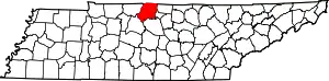 Location within the U.S. state of Tennessee | |
 Tennessee's location within the U.S. | |
| Coordinates: 36°28′N 86°28′W | |
| Country | |
| State | |
| Founded | November 1786 |
| Named for | Jethro Sumner[1] |
| Seat | Gallatin |
| Largest city | Hendersonville |
| Area | |
| • Total | 543 sq mi (1,410 km2) |
| • Land | 529 sq mi (1,370 km2) |
| • Water | 14 sq mi (40 km2) 2.5% |
| Population | |
| • Estimate (2019) | 191,283 |
| • Density | 340/sq mi (130/km2) |
| Congressional district | 6th |
| Website | www |
As of the 2010 census, the population was 160,645.[2] Its county seat is Gallatin,[3] and its largest city is Hendersonville. The county is named for American Revolutionary War hero General Jethro Sumner.
Sumner County is part of the Nashville-Davidson–Murfreesboro–Franklin, TN Metropolitan Statistical Area. The county is made up of eight cities, including Gallatin, Goodlettsville, Hendersonville, Millersville, Mitchellville, Portland, Westmoreland, and White House. Sumner County is 25 miles (40 km) northeast of Nashville, Tennessee.
History
Prior to the European colonization of North America, the county had been inhabited by various cultures of Native Americans for several thousand years. Nomadic Paleo and Archaic hunter-gatherer campsites, as well as substantial Woodland and Mississippian-period occupation sites and burial grounds, can be found scattered throughout the county, particularly along the waterways. The majority of these sites exist along natural waterways, with the highest concentration occurring along what is now known as the Cumberland River. Mississippian period earthwork mounds can still be seen in Hendersonville, and most notably, at Castalian Springs. Long before Europeans entered the area, Native Americans made use of the natural hot springs for their medicinal and healing properties.
British colonial longhunters traveled into the area as early as the 1760s, following existing Indian and buffalo trails. By the early 1780s, they had erected several trading posts in the region. The most prominent was Mansker's Station, which was built by Kasper Mansker near a salt lick (where modern Goodlettsville would develop). Another was Bledsoe's Station, built by Isaac Bledsoe at Castilian Springs.[1] Sumner County was organized in 1786, just 3 years after the end of the American Revolutionary War, when Tennessee was still the western part of North Carolina.
The county was developed for agriculture: tobacco and hemp, and blooded livestock. Numerous settlers came from central Kentucky's Bluegrass Region, where these were the most important products. Middle Tennessee had fertile lands that could be used for similar crops and supported high-quality livestock as well. The larger planters depended on the labor of enslaved African Americans, but Middle Tennessee had a lower proportion of slaves in the population than in West Tennessee, the plantation area of Memphis and the Delta, where cotton was cultivated.
During the American Civil War, most of Tennessee was occupied by Union troops from 1862. This led to a breakdown in civil order in many areas.[4] The Union commander, Eleazer A. Paine, was based at Gallatin, the county seat. He was notoriously cruel and had suspected spies publicly executed without trial in the town square.[5] He was eventually replaced because of his mistreatment of the people.
In 1873 the county was hit hard by the fourth cholera pandemic of the century, which had begun about 1863 in Asia. It eventually reached North America and was spread by steamboat passengers who traveled throughout the waterways, especially in the South on the Mississippi River and its tributaries. An estimated 120 persons died of cholera in Sumner County in 1873, mostly during the summer. The disease was spread mainly through contaminated water, due to the lack of sanitation. About four-fifths of the county's victims were African Americans. Many families, both black and white, lost multiple members.[6] In the United States overall, about 50,000 persons died of cholera in the 1870s.[6]
Geography
According to the U.S. Census Bureau, the county has a total area of 543 square miles (1,410 km2), of which 529 square miles (1,370 km2) is land and 14 square miles (36 km2) (2.5%) is water.[7]
Sumner County is located in Middle Tennessee on the state's northern border with Kentucky. The Cumberland River was important in early trade and transportation for this area, as it flows into the Ohio River to the west. That leads to the Mississippi River, and downriver to the major port of New Orleans. Sumner County is in the Greater Nashville metropolitan area.
Adjacent counties
- Davidson County (southwest)
- Macon County (east)
- Robertson County (west)
- Trousdale County (southeast)
- Wilson County (south)
- Allen County, Kentucky (northeast)
- Simpson County, Kentucky (northwest)
State protected areas
- Bledsoe Creek State Park
- Cragfont State Historic Site
- Gallatin Steam Plant Wildlife Management Area
- Old Hickory Lock and Dam Wildlife Management Area (part)
- Rock Castle State Historic Site
- Taylor Hollow State Natural Area
- Wynnewood State Historic Site
Demographics
| Historical population | |||
|---|---|---|---|
| Census | Pop. | %± | |
| 1800 | 4,616 | — | |
| 1810 | 13,792 | 198.8% | |
| 1820 | 19,211 | 39.3% | |
| 1830 | 20,569 | 7.1% | |
| 1840 | 22,415 | 9.0% | |
| 1850 | 22,717 | 1.3% | |
| 1860 | 22,030 | −3.0% | |
| 1870 | 23,711 | 7.6% | |
| 1880 | 23,625 | −0.4% | |
| 1890 | 23,668 | 0.2% | |
| 1900 | 26,072 | 10.2% | |
| 1910 | 25,621 | −1.7% | |
| 1920 | 27,708 | 8.1% | |
| 1930 | 28,622 | 3.3% | |
| 1940 | 32,719 | 14.3% | |
| 1950 | 33,533 | 2.5% | |
| 1960 | 36,217 | 8.0% | |
| 1970 | 56,106 | 54.9% | |
| 1980 | 85,790 | 52.9% | |
| 1990 | 103,281 | 20.4% | |
| 2000 | 130,449 | 26.3% | |
| 2010 | 160,645 | 23.1% | |
| 2019 (est.) | 191,283 | [8] | 19.1% |
| U.S. Decennial Census[9] 1790-1960[10] 1900–1990[11] 1990-2000[12] 2010–2014[2] | |||
2010 census
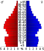
As of the census of 2010,[14] there were 160,645 people, 60,975 households, and 44,593 families living in the county. The population density was 303.68 persons per square mile. The housing unit density was 115.26 units per square mile. The racial makeup of the county was 89.67% White, 6.42% African American, 1.02% Asian, 0.29% Native American, 0.07% Pacific Islander, and 1.45% from two or more races. Those of Hispanic or Latino origins constituted 3.93% of the population.
Out of all of the households, 26.08% had children under the age of 18 living in them, 57.05% were married couples, 4.37% had a male householder with no wife present, 11.72% had a female householder with no husband present, and 26.87% were non-families. 22.07% of all householders were made up of individuals, and 8.29% were one person aged 65 or older. The average household size was 2.61 and the average family size was 3.05.
The age distribution was 25.29% under the age of 18, 62.10% ages 18 to 64, and 12.61% ages 65 and over. The median age was 38.6 years. 51.20% of the population were females, and 48.80% were males.
The median household income in the county was $54,916, and the median family income was $65,313. Males had a median income of $46,606, versus $35,256 for females. The per capita income was $26,014. About 7.3% of families and 10.1% of the population were below the poverty line, including 13.9% of those under the age of 18 and 9.4% of those age 65 and over.
2000 census
At the 2000 census there were 130,449 people, 48,941 households, and 37,048 families living in the county. The population density was 246 people per square mile (95/km2). There were 51,657 housing units at an average density of 98 per square mile (38/km2). The racial makeup of the county was 91.49% White, 5.78% Black or African American, 0.29% Native American, 0.66% Asian, 0.03% Pacific Islander, 0.80% from other races, and 0.96% from two or more races. 1.76% of the population were Hispanic or Latino of any race.[15] In 2000 Of the 48,941 households 36.30% had children under the age of 18 living with them, 61.10% were married couples living together, 10.80% had a female householder with no husband present, and 24.30% were non-families. 20.30% of households were one person and 7.20% were one person aged 65 or older. The average household size was 2.64 and the average family size was 3.04.
The age distribution was 26.30% under the age of 18, 8.00% from 18 to 24, 30.70% from 25 to 44, 24.30% from 45 to 64, and 10.70% 65 or older. The median age was 36 years. For every 100 females, there were 95.90 males. For every 100 females age 18 and over, there were 92.30 males.
The median household income was $46,030 and the median family income was $52,125. Males had a median income of $36,875 versus $25,720 for females. The per capita income for the county was $21,164. About 6.20% of families and 8.10% of the population were below the poverty line, including 10.50% of those under age 18 and 10.00% of those age 65 or over.
Education
Public schools
Schools in the county are governed by the Sumner County Board of Education. The twelve-member group consists of eleven elected representatives from each of the eleven educational districts in the county, as well as the Director of Schools. The members serve staggered four-year terms; the Director serves under contract with the Board of Education. The board conducts monthly meetings that are open to the public.
Private schools
- Saint John Vianney Catholic Elementary School (K–8)
- Southside Christian School (K–12)
- Sumner Academy (K–8)
- John Paul II High School
- Aaron Academy (K-12)
Colleges
- Volunteer State Community College
- Union University (Hendersonville Campus)
- Welch College
Communities
Cities
- Gallatin (county seat)
- Goodlettsville (partly in Davidson County)
- Hendersonville
- Millersville (partly in Robertson County)
- Mitchellville
- Portland (partly in Robertson County)
- White House (small part in Robertson County)
Town
Census-designated places
Unincorporated communities
Notable people
Submarine innovator Horace Lawson Hunley was born in Sumner County on June 20, 1823. On October 15, 1863, Hunley, along with seven other crewmen, drowned while making a test dive in Charleston Harbor near Fort Pinckney. Following his death, the submarine, unofficially known as the "Fish Boat," was renamed the H.L. Hunley in his honor. On the night of February 17, 1864, the Hunley sank the USS Housatonic, making it the first submarine to sink an enemy vessel.
Watergate prosecutor and criminal defense trial lawyer James F. Neal was born and raised in Oak Grove and graduated from Sumner High School in Portland in 1947.
R&B National Recording Artist Nacole Rice was born in Sumner County.[16]
Politics
Though part of historically Democratic Middle Tennessee, Sumner County was one of the first counties in the region to switch to the Republican Party. It has voted for the GOP solidly in every election back to 1984, with the sole exception being Bill Clinton's victory in the county in 1992.
| Year | Republican | Democratic | Third Parties |
|---|---|---|---|
| 2020 | 68.5% 63,454 | 29.9% 27,680 | 1.6% 1,496 |
| 2016 | 70.1% 50,129 | 25.4% 18,161 | 4.5% 3,215 |
| 2012 | 70.3% 46,003 | 28.4% 18,579 | 1.3% 875 |
| 2008 | 66.7% 44,949 | 31.9% 21,487 | 1.4% 926 |
| 2004 | 64.8% 40,181 | 34.6% 21,458 | 0.5% 329 |
| 2000 | 54.7% 27,601 | 43.8% 22,118 | 1.5% 758 |
| 1996 | 48.4% 20,863 | 44.5% 19,205 | 7.2% 3,086 |
| 1992 | 41.3% 17,401 | 46.0% 19,387 | 12.7% 5,344 |
| 1988 | 62.2% 19,523 | 37.3% 11,702 | 0.5% 164 |
| 1984 | 61.1% 18,442 | 38.2% 11,535 | 0.7% 209 |
| 1980 | 44.4% 11,876 | 52.9% 14,150 | 2.7% 709 |
| 1976 | 36.1% 7,946 | 62.9% 13,848 | 1.0% 213 |
| 1972 | 66.1% 10,020 | 30.3% 4,596 | 3.6% 541 |
| 1968 | 27.4% 4,519 | 26.5% 4,376 | 46.1% 7,592 |
| 1964 | 27.4% 3,437 | 72.6% 9,102 | |
| 1960 | 34.0% 3,491 | 65.2% 6,687 | 0.8% 83 |
| 1956 | 22.3% 2,123 | 77.3% 7,368 | 0.4% 36 |
| 1952 | 28.1% 2,233 | 71.4% 5,674 | 0.5% 40 |
| 1948 | 15.8% 793 | 73.7% 3,688 | 10.5% 525 |
| 1944 | 19.5% 990 | 80.3% 4,076 | 0.2% 10 |
| 1940 | 18.8% 834 | 80.8% 3,591 | 0.5% 22 |
| 1936 | 14.1% 517 | 85.8% 3,146 | 0.1% 3 |
| 1932 | 8.9% 382 | 90.5% 3,893 | 0.7% 28 |
| 1928 | 29.1% 1,045 | 70.8% 2,541 | 0.1% 2 |
| 1924 | 13.9% 435 | 84.3% 2,631 | 1.8% 57 |
| 1920 | 25.6% 1,268 | 74.0% 3,674 | 0.4% 21 |
| 1916 | 19.3% 612 | 78.3% 2,487 | 2.4% 76 |
| 1912 | 22.6% 769 | 72.9% 2,477 | 4.4% 150 |
| 1908 | 22.1% 673 | 77.0% 2,343 | 0.9% 28 |
| 1904 | 21.1% 599 | 76.6% 2,178 | 2.3% 65 |
| 1900 | 22.7% 776 | 75.7% 2,589 | 1.6% 62 |
| 1896 | 27.3% 1,215 | 71.3% 3,171 | 1.3% 59 |
| 1892 | 18.8% 677 | 58.7% 2,121 | 22.5% 813 |
| 1888 | 30.4% 1,228 | 68.8% 2,778 | 0.8% 34 |
| 1884 | 29.6% 945 | 69.7% 2,225 | 0.7% 22 |
| 1880 | 27.4% 1,092 | 72.6% 2,893 |
References
- Dee Gee Lester, "Sumner County," Tennessee Encyclopedia of History and Culture. Retrieved: April 7, 2013.
- "State & County QuickFacts". United States Census Bureau. Retrieved December 7, 2013.
- "Find a County". National Association of Counties. Archived from the original on March 2, 2011. Retrieved June 7, 2011.
- Durham, Walter T. Rebellion Revisited: A History of Sumner County, Tennessee from 1861 to 1870 (Franklin, Tennessee: Hillsboro Press, 1999, 2nd edition)
- Alice Williamson Diary, Duke University Special Collections Library, accessed 11 October 2007
- "The Cholera Epidemic of 1873 in the United States. (The Introduction of Epidemic Cholera Through the Agency of the Mercantile Marine ... By John M. Woodworth. Reports Prepared Under the Direction of the Surgeon-General of the Army:-A. History of the Cholera Epidemic of 1873 by Ely McClellan. B. History of the Travels of Asiatic Cholera. By John C. Peters and Ely McClellan. C. Bibliography of Cholera. By John S. Billings.)". April 28, 1875. pp. 159–163 – via Google Books.
- "2010 Census Gazetteer Files". United States Census Bureau. August 22, 2012. Retrieved April 14, 2015.
- "Population and Housing Unit Estimates". Retrieved July 20, 2019.
- "U.S. Decennial Census". United States Census Bureau. Retrieved April 14, 2015.
- "Historical Census Browser". University of Virginia Library. Retrieved April 14, 2015.
- Forstall, Richard L., ed. (March 27, 1995). "Population of Counties by Decennial Census: 1900 to 1990". United States Census Bureau. Retrieved April 14, 2015.
- "Census 2000 PHC-T-4. Ranking Tables for Counties: 1990 and 2000" (PDF). United States Census Bureau. April 2, 2001. Retrieved April 14, 2015.
- Based on 2000 census data
- "U.S. Census website". United States Census Bureau. Retrieved October 5, 2019.
- "U.S. Census website". United States Census Bureau. Retrieved May 14, 2011.
- Biography, Nacole Rice official site; retrieved April 7, 2013.
- Leip, David. "Dave Leip's Atlas of U.S. Presidential Elections". uselectionatlas.org. Retrieved March 12, 2018.
Further reading
- Cisco, Jay Guy (1909). Historic Sumner County, Tennessee, with Genealogies of the Bledsoe, Cage and Douglass Families and Genealogical Notes of Other Sumner Families. Nashville, Tennessee: Folk-Keelin Printing Company. OCLC 5692694972.
External links
| Wikimedia Commons has media related to Sumner County, Tennessee. |
- Official site
- Sumner County Schools
- TNGenWeb
- Tennessee Central Economic Alliance for Sumner County
- Sumner County at Curlie
Places adjacent to Sumner County, Tennessee | ||||||||||
|---|---|---|---|---|---|---|---|---|---|---|
| ||||||||||
Municipalities and communities of Sumner County, Tennessee, United States | ||
|---|---|---|
| Cities | Sumner County map | |
| Town | ||
| CDPs | ||
| Unincorporated communities | ||
| Footnotes | ‡This populated place also has portions in an adjacent county or counties | |
| ||
| Principal City | ||
|---|---|---|
| Other Major Cities | ||
| Counties | ||

| Authority control |
|---|