Texas State Highway 141
Texas State Highway 141 (SH 141) is a Texas state highway in Jim Wells and Kleberg counties.[1]
| ||||
|---|---|---|---|---|
 | ||||
| Route information | ||||
| Maintained by TxDOT | ||||
| Length | 16.272 mi[1] (26.187 km) | |||
| Existed | 1929–present | |||
| Major junctions | ||||
| West end | ||||
| East end | ||||
| Location | ||||
| Counties | Jim Wells, Kleberg | |||
| Highway system | ||||
| ||||

Route description
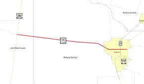
The western terminus of SH 141 is at US 281 (Future I-69C) in Jim Wells County; the continuation past US 281 to Benavides is designated FM 2295. The route travels east into Kleberg County and into the city of Kingsville, where it ends at US 77 (Future I-69E).[1][2]
History
SH 141 was originally designated on September 18, 1929 from Kingsville west to Benavides, [3] but was shortened to its current route on July 15, 1935.[4] The designation was extended slightly to the east, to the bypass of US 77 in Kingsville, on June 26, 1962.[1]
Major intersections
| County | Location | mi[5] | km | Destinations | Notes |
|---|---|---|---|---|---|
| Jim Wells | | 0.0 | 0.0 | Western terminus; eastern terminus of FM 2295; U.S. 281 is the future Interstate 69C | |
| Kleberg | Kingsville | 13.7 | 22.0 | Southern terminus of Spur 169 | |
| 15.3 | 24.6 | ||||
| 16.3 | 26.2 | Eastern terminus; U.S. 77 is the future Interstate 69E | |||
| 1.000 mi = 1.609 km; 1.000 km = 0.621 mi | |||||
References
- Transportation Planning and Programming Division (n.d.). "State Highway No. 141". Highway Designation Files. Texas Department of Transportation. Retrieved 2011-01-06.
- Transportation Planning and Programming Division (2012). Texas County Mapbook (PDF) (Map) (2012 ed.). 1:120,000. Texas Department of Transportation. p. 441. OCLC 867856197. Retrieved 2011-01-06.
- (PDF) https://publicdocs.txdot.gov/minord/MinuteOrderDocLib/003673786.pdf. Missing or empty
|title=(help) - (PDF) https://publicdocs.txdot.gov/minord/MinuteOrderDocLib/003673871.pdf. Missing or empty
|title=(help) - Google (2011-01-06). "Overview map of Texas State Highway 141 Distances Between Interchanges" (Map). Google Maps. Google. Retrieved 2011-01-06.
This article is issued from Wikipedia. The text is licensed under Creative Commons - Attribution - Sharealike. Additional terms may apply for the media files.
