The Cheviot
The Cheviot (/ˈtʃivɪət/) is the highest summit in the Cheviot Hills in the far north of England, only 1 1⁄4 miles (2 kilometres) from the Scottish border. It is the last major peak on the Pennine Way, if travelling from south to north, before the descent into Kirk Yetholm.
| The Cheviot | |
|---|---|
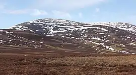 The Cheviot in snow | |
| Highest point | |
| Elevation | 815 m (2,674 ft) [1] |
| Prominence | 556 m (1,824 ft) [2] |
| Parent peak | Broad Law |
| Listing | Marilyn, Hewitt, County Top, Nuttall |
| Coordinates | 55°28′42″N 2°08′44″W |
| Geography | |
 The Cheviot The Cheviot in Northumberland | |
| Location | Cheviot Hills, England |
| OS grid | NT909205 |
| Topo map | OS Landranger 74/75 |
| Geology | |
| Mountain type | Stratovolcano (extinct) |
Etymology
Though the exact etymology behind the Cheviot is unknown, it is generally understood to be Celtic. It can be most plausibly explained as a formation of the Brittonic *ceμ-, 'a ridge', and the nominal suffix -ed.[3]
Geology
The Cheviot is an extinct stratovolcano, eruptive during the Caledonian orogeny (490-390 Ma).[4] The mountain is heavily eroded.[4] Originally, the mountain may have been as high as 10,000 ft (3,000 m),[5] with a diameter of perhaps of 37 miles (60km).[5]
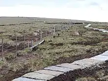
The summit of the Cheviot is very flat.
It is covered with an extensive peat bog up to 6 ft (2 m) deep; the Northumberland National Park Authority have laid down stone slabs on the main access footpath to prevent erosion damage to the peat and to make the approach to the summit safer for walkers.
Access
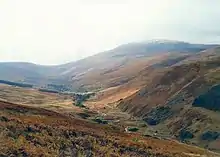
Other than the route via the Pennine Way, most routes up the Cheviot start from the Harthope Burn side to the northeast, which provides the nearest access by road. The summit is around 3 mi (5 km) from the road-end at Langleeford; across the valley to the east is the rounded peak of Hedgehope. There are routes following the ridges above either side of the valley, and a route that sticks to the valley floor until it climbs to the summit of the Cheviot from the head of the valley.
Although the Pennine Way does a 2 mi (3 km) out-and-back detour to the Cheviot, many walkers who come this way omit it, since the stage (the most northerly) is 29 mi (47 km) long.
History
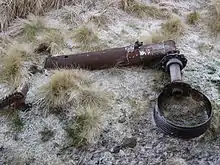
North of the summit, in the peat bogs, are the remains of a crashed B-17 bomber, which hit the mountain due to a navigational error in World War II. The more recognisable pieces of wreckage have been removed, but pieces of the aircraft can still be found.
View
The view is obscured greatly by the flatness of the summit plateau. Nevertheless, on a clear day the following are visible (from west, clockwise); Broad Law, Moorfoot Hills, Pentland Hills, the Ochils, Lammermuir Hills, Ros Hill, Long Crag, Urra Moor, Tosson Hill, Burnhope Seat, Cross Fell, Helvellyn, Scafell Pike, Skiddaw, Sighty Crag, Peel Fell, and Queensberry.
Subsidiary SMC summits
| Summit | Height (m) | Listing |
|---|---|---|
| Cairn Hill West Top [Hangingstone Hill] | 743 | DT,CoH,Bg,xN[6] |
References
- http://www.hill-bagging.co.uk/mountaindetails.php?qu=&rf=2302
- http://www.hill-bagging.co.uk/mountaindetails.php?qu=&rf=2302
- James, Alan. "A Guide to the Place-Name Evidence" (PDF). SPNS - The Brittonic Language in the Old North. Retrieved 25 November 2018.
- Kille, Ian. "15. Geology of the battlefield and wider landscape". Flodden 1513. Retrieved 19 November 2020.
- Upton, B. G. J. (2015). Volcanoes and the Making of Scotland. Dunedin Academic Press Ltd. ISBN 978-1780465418. Retrieved 14 August 2019.
- http://www.hill-bagging.co.uk/mountaindetails.php?rf=1846
External links
- Computer generated summit panorama The Cheviot
Marilyns of Northern England | ||
|---|---|---|
| 1. Northumberland |  | |
| 2. Northern Lakeland | ||
| 3. Western Lakeland | ||
| 4. Central and Southern Lakeland | ||
| 5. Eastern Lakeland | ||
| 6. North Pennines and Durham | ||
| 7. Northern Yorkshire Dales | ||
| 8. Southern Yorkshire Dales | ||
| 9. North York Moors to the Humber | ||
| 10. Forest of Bowland | ||