The Heights, Jersey City
The Heights or Jersey City Heights is a district in the north end of Jersey City, New Jersey, atop the New Jersey Palisades overlooking Hoboken to the east and Croxton in the Meadowlands to the west.[1][2]

_at_Ferry_Street_Jersey_City_Heights.jpg.webp)
The southern border of The Heights is generally considered to be north of Bergen Arches and The Divided Highway, while Paterson Plank Road in Washington Park near Transfer Station is its main northern boundary. Its postal area ZIP code is 07307. The Heights mostly contains two- and three-family houses and low-rise apartment buildings, and is similar to North Hudson architectural style and neighborhood character.
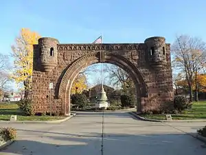
Central Avenue is its primary commercial thoroughfare,[3][4] with residential neighborhoods on both sides and more than 240 businesses serving the area.[5] Pershing Field (named for General John J Pershing is a memorial park in the center of the district that was built on a military training ground. It offers a green space, baseball fields, a swimming pool and ice-skating rink. The adjacent Jersey City Reservoir No. 3 has been preserved as a state designated wetland and park. Many stately Victorian and Edwardian homes distinguish the Heights, particularly along Summit Avenue and Sherman Place [6]
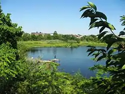
Riverview-Fiske Park along Palisade and Ogden Avenues, is a neighborhood on the east side of the Palisades which offers views of Hoboken and the Manhattan skyline. The Schurman House, and the Van Vorst Farmhouse, (a stone building from 1742, the city's oldest) are located in the vicinity. Pohlmann's Hall at 154 Ogden Avenue received its federal historical designation in September 1985. Christ Hospital is south on Palisade Avenue.
Western Slope descending a cuesta from Kennedy Boulevard the overlooks Croxton in the Meadowlands. At the corner of Manhattan Avenue, in the Dr. Leonard J. Gordon Park is larger than life 1907 sculpture Buffalo and Bears by Solon Hannibal Borglum.
Transportation
An elevator at Congress Street and Paterson Plank Road descends to the 9th Street-Congress Street station of the Hudson-Bergen Light Rail.[6] Mountain Ave [7] and New York Ave [8] are the two streets that travel along the face of the cliffs. New Jersey Transit bus routes 82, 83, 84, 85, 86, 87 and 88, and serve the district locally to North Hudson and Journal Square while the 123 and 125 also continue to Port Authority Bus Terminal (PABT). New Jersey Transit 119 Bayonne to PABT via Journal Square and Central Avenue also serves the area.
History
The Heights was part of the colony of Pavonia, New Netherland, the superintendent of which was the American patriarch of the Van Vorst family. A Van Vorst House built in 1742 by the family (now on Palisade Avenue) is considered to be the oldest building in Hudson County. Summit Avenue, slightly to the west follows an Hackensack Indian trail that became the main road from the villages of Communipaw and Bergen and eventually connected to the Paterson and Hackensack Plank Roads.[9]
The area comprising most of the Heights was once an independent municipality, known as Hudson City. It was incorporated as a town in 1852, and later into a city in 1855. The Town Hall, erected on Oakland Avenue, still stands today. Garrett D. Van Reipen was that city's first mayor.[10] (According to the NY Times, E.R.V Wright was the first Mayor of Hudson City.[11]) Hudson City, along with the Town of Bergen and the Township of Greenville, merged with Jersey City in 1873.[10]
On March 27, 1868 Hudson City became the birthplace of its most famous namesake, the new Hudson City Savings Bank, when it received a special charter from the State of New Jersey Legislature to open in what was then the small City of Hudson, New Jersey. Hudson's mayor Garrett D. Van Reipen became the first President of the small bank, which was located on Newark Avenue.[10] By the end of the 19th Century, Hudson City Savings Bank had accumulated assets and deposits of over US$1 million. In the 1920s, the savings bank opened its second branch, and moved from Newark Avenue to 587 Summit Avenue in Jersey City, and later moved its headquarters to Bergen County.
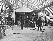
America's first motion picture industry can trace its roots to the Hudson River towns of New Jersey, especially Fort Lee.[12] Nestor Studios (which merged into Universal Studios) began in Bayonne. Pathé, the France-based company that during the first part of the 20th century was the largest film equipment and production company in the world, established an American factory and studio facility in The Heights in 1910, the building of which still stands overlooking Paterson Plank Road. It also established the Eclectic Film Company as a subsidiary distribution company for both its American and European product. Although the Jersey City plant produced moderately popular comedies, dramas, and newsreels largely directed at the US market, Perils of Pauline was the first American-made Pathé effort to achieve worldwide success under the Eclectic banner.[13][14][15]
Education
Jersey City Public Schools operates area public schools.
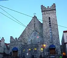
The Roman Catholic Archdiocese of Newark operates area Catholic Schools. St. Anne School was located in Jersey City Heights, and opened in 1904.[16] Its enrollment declined by 33 in 2011 and increased by 22 in 2012. James Carroll, a member of the Jersey City Police Department and a member of the school board, Carroll stated that the 2011 decline was due to parents being afraid that the school would close.[17] In 2011 the archdiocese considered closing the school, but a fundraising generated sufficient money to keep it open.[16] It closed in 2012.[17] That year the building housed the K-8 grades of the Hoboken Charter School on a temporary basis as the regular K-8 building of the charter school had a fire.[18]
See also
References
- "Neighborhoods". Retrieved 13 December 2015.
- "Community". Retrieved 13 December 2015.
- "Jersey City Shopping Districts". Retrieved 13 December 2015.
- Central Avenue Special Improvement District
- "The Jersey City Heights Neighborhood History". www.jcheights.com. Retrieved 2019-03-10.
- "GET NJ – The Heights Section of Jersey City". Retrieved 13 December 2015.
- "Hudson County 7311 straight line diagram" (PDF). New Jersey Department of Transportation. Archived from the original (PDF) on 2012-10-17. Retrieved 2009-21-15. Check date values in:
|access-date=(help) - "Hudson County 6671 straight line diagram" (PDF). New Jersey Department of Transportation. Retrieved 2009-21-15. Check date values in:
|access-date=(help) - "Jersey City History – Jersey City's Oldest House". Retrieved 13 December 2015.
- Hudson City Savings Bank Archived 2007-09-17 at the Wayback Machine
- NY Times, 1855 The City of Hudson
- "Fort Lee Film Commission - Fort Lee, NJ". Retrieved 13 December 2015.
- Koszarski, Richard (2004), Fort Lee: The Film Town, Rome, Italy: John Libbey Publishing -CIC srl, ISBN 0-86196-653-8
- "Studios and Films". Fort Lee Film Commission. Retrieved 2011-05-30.
- Fort Lee Film Commission (2006), Fort Lee Birthplace of the Motion Picture Industry, Arcadia Publishing, ISBN 0-7385-4501-5
- Zeitlinger, Ron (2011-05-22). "Once doomed, St. Anne's School in Jersey City gets new life". The Jersey Journal. Retrieved 2020-06-24.
- Conte, Michaelangelo (2012-02-17). "Newark Archdiocese to close St. Anne's School in Jersey City, Mater Dei Academy in Kearny". The Jersey Journal. Retrieved 2020-06-24.
- Thorbourne, Ken (2012-01-18). "Fire-devastated Hoboken Charter School to reopen in Jersey City Heights". The Jersey Journal. Retrieved 2020-06-24.
Sources
Hudson County New Jersey Street Map. Hagstrom Map Company, Inc. 2008. ISBN 978-0-88097-763-0.