Thomas Road
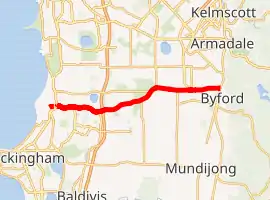
Thomas Road is a major west-east road in the far southern suburbs of Perth, Western Australia, connecting Rockingham Road (part of Highway 1) in Kwinana's industrial area with Kwinana's urban area, before bridging Perth's agricultural fringe to meet the South Western Highway in Byford, just south of Armadale.[1] Thomas Road was the terminus of the Kwinana Freeway from 1993 until 2002, and presently serves as the terminus of Tonkin Highway after its extension beyond Albany Highway in 2003.
Thomas Road | |
|---|---|
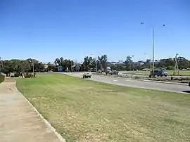 | |
Intersection of Rockingham Road and Thomas Road | |
| |
| General information | |
| Type | Road |
| Length | 23 km (14 mi) |
| Opened | 1950s |
| Route number(s) | |
| Major junctions | |
| West end | |
| |
| East end | |
| Location(s) | |
| Major suburbs | Kwinana Beach, Casuarina, Oakford |
Thomas Road forms the entirety of State Route 21.[2]
Major intersections
 Rockingham Road (National Route 1) – to Spearwood and Fremantle / Rockingham and Mandurah
- Gilmore Avenue – Kwinana Town Centre, Parmelia, Calista, Leda
- Johnson Road – Bertram, Wellard
 Kwinana Freeway (State Route 2) – Jandakot, Perth CBD / Rockingham
 Nicholson Road (State Route 31) – Canning Vale, Cannington
 Tonkin Highway (State Route 4) – Gosnells, Perth Airport
 South Western Highway (State Route 20) – Armadale, Bunbury
See also
![]() Australian roads portal
Australian roads portal
References
- 2011 UBD Perth and Surrounds Street Directory. Australia: Universal Publishers Pty Ltd. 2011. pp. 409–412, 426–429. ISBN 978 0 7319 2653 4.
- Distance book (12 ed.). Main Roads Western Australia. 2012. pp. 4–5. ISBN 0 7309 7657 2. Archived from the original on 24 October 2012. Retrieved 3 January 2014.
| National Highways | |||
|---|---|---|---|
| National Routes | |||
| State Routes | |||
| Tourist Drives | |||
This article is issued from Wikipedia. The text is licensed under Creative Commons - Attribution - Sharealike. Additional terms may apply for the media files.