Tilpa
Tilpa is a town in the Far West region of New South Wales, Australia. The town is located on the Darling River, in the Central Darling Shire local government area, 917 kilometres (570 mi) north west of the state capital, Sydney.
| Tilpa New South Wales | |
|---|---|
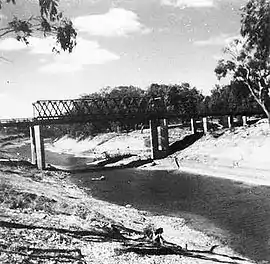 The Darling River at Tilpa c. 1945. The punt can be seen behind the new bridge | |
Tilpa | |
| Coordinates | 30°56′11″S 144°25′0″E |
| Population | 44 (2016 census)[1] |
| Postcode(s) | 2840 |
| Elevation | 88 m (289 ft) |
| Location |
|
| LGA(s) | Central Darling Shire |
| State electorate(s) | Barwon |
| Federal Division(s) | Farrer |
At the 2016 census, Tilpa and the large surrounding area had a population of 44.[1] The town itself is said to have a population of nine.[2]
The Darling River at Tilpa has erratic flows and is often dry in periods of drought. However floods in 1956 saw the Darling River span 80 kilometres (50 mi) at its widest, isolating Tilpa for five months.[3]
History
In its heyday, Tilpa was an important river port with paddle steamers delivering supplies to nearby sheep stations and returning down river laden with bales of wool.[4] The wool was taken to Wentworth—at the confluence of the Darling and Murray Rivers—and then either to Adelaide or to Echuca for passage to the port at Melbourne.[5] The town was home to a punt, allowing sheep, horses and people to cross the Darling River safely, for a fee.[4] The punt has since been replaced by a bridge. The photo of the punt and the bridge dates it to after 1963 as that is when the bridge was completed.
Culture
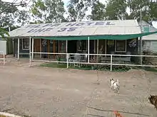
The local pub—the Tilpa Hotel—was built over 100 years ago. A timber and corrugated iron building, the inside walls are covered in messages and autographs placed by visitors in return for a donation to the Royal Flying Doctor Service.[6] A feature of the town is a Boer War memorial in Australia that includes a commemorative to Harry "Breaker" Morant, who was controversially executed by the British Army for murdering Boer prisoners.[5] The town also claims to have the smallest heritage trail in Australia (two signs across the street from each other) and the only cemetery in Australia with no interments.[5][7]
Economy
Tilpa is mainly an agricultural area, with sheep grazing the primary activity, and some pockets of irrigated land along the river. Tourism, including farmstay programs on local stations, is the other major local industry. Fishing and camping are popular along the river.[4] The prolonged drought in 2007 saw Tilpa run out of potable water. A Sydney-based company has offered to trial a portable water filtration plant to improve the quality of both the river and bore water.[8]
See also
References
- Australian Bureau of Statistics (27 June 2017). "Tilpa (State Suburb)". 2016 Census QuickStats. Retrieved 21 March 2018.

- Simons, Margaret (March 2020). "Cry Me a River". Quarterly Essay. Retrieved 14 August 2020.
- "Tilpa". Tourism New South Wales. Retrieved 3 October 2008.
- "Tilpa". WISE Basins. National Parks and Wildlife (New South Wales). Retrieved 2 October 2008.
- "Visit Outback NSW: Tilpa". Outback NSW Tourism. Retrieved 2 October 2008.
- "Tilpa Pub". NSW Holidays. Retrieved 3 October 2008.
- Wilson, Mary (26 May 2008). "Bush cemeteries". Western NSW History: Cemeteries. Retrieved 3 October 2008. : Confirmation of lack of graves in cemetery.
- "Cobb says no funding help for Tilpa water woes". Australian Broadcasting Corporation. 18 May 2007. Retrieved 3 October 2008.
External links
![]() Media related to Tilpa at Wikimedia Commons
Media related to Tilpa at Wikimedia Commons