Trient (river)
The Trient (French: Le Trient) is a river in western Valais. It takes its source at the Trient Glacier in the Mont Blanc Massif and joins the Rhone between Vernayaz and Martigny. Only two villages are located along the Trient: Trient and Vernayaz. However, the Trient Valley includes many other settlements: notably Finhaut, Les Marécottes and Salvan, all located on south-east facing terraces, at significant elevations above the valley floor.
| Trient | |
|---|---|
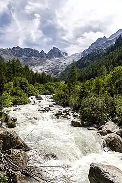 Head of the Trient valley and Trient Glacier | |
| Native name | Le Trient |
| Location | |
| Country | Switzerland |
| Canton | Valais |
| Settlements | Trient, Vernayaz |
| Physical characteristics | |
| Source | Trient Glacier |
| • location | Trient |
| • coordinates | 46°00′50″N 07°01′46″E |
| • elevation | 2,500 m (8,200 ft) |
| Mouth | |
• location | Rhone between Vernayaz and Martigny, Valais |
• coordinates | 46°08′16″N 07°03′05″E |
• elevation | 450 m (1,480 ft) |
| Basin features | |
| Progression | Rhône→ Mediterranean Sea |
The Trient is essentially a wild alpine river mostly fed by glacial runoff. High in the Alps it is fed by numerous small streams that run down the surrounding mountains. Notable streams are the Eau Noire (collecting the Barberine below the Lac d'Emosson) and the Triège. Shortly after passing the Trient Gorges, the river flows into the Rhone just south-east of the village of Vernayaz.[1]
References
External links
 Media related to Trient (rivière) at Wikimedia Commons