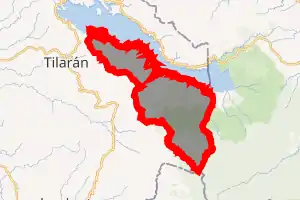
Tronadora
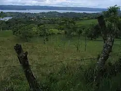
Tronadora is a district of the Tilarán canton, in the Guanacaste province of Costa Rica.[1][2] It is located on the west shore of Lake Arenal. It is connected by road to Tejona and Tilarán along Route 142.[3] Roughly 3 miles down the coast of Lake Arenal to the west is the Tilawa Viento Surf Center.The weather is changeable due to the proximity of the confluence of the Pacific coast weather pattern and the inland lake weather pattern. It is drier and cooler than the Pacific coast due to the elevation of 614 meters (2014 feet).
Tronadora | |
|---|---|
 Tronadora | |
Tronadora district | |
 Tronadora Tronadora district location in Costa Rica | |
| Coordinates: 10.4202973°N 84.8526241°W | |
| Country | |
| Province | Guanacaste |
| Canton | Tilarán |
| Area | |
| • Total | 142.28 km2 (54.93 sq mi) |
| Elevation | 600 m (2,000 ft) |
| Population (2011) | |
| • Total | 1,795 |
| • Density | 13/km2 (33/sq mi) |
| Time zone | UTC−06:00 |
| Postal code | 50803 |
Locations
- Poblados: Arenal Viejo, Colonia Menonita, Río Chiquito Abajo, Silencio
Demographics
| Historical population | |||
|---|---|---|---|
| Census | Pop. | %± | |
| 1927 | 734 | — | |
| 1950 | 1,614 | 119.9% | |
| 1963 | 2,565 | 58.9% | |
| 1973 | 2,623 | 2.3% | |
| 1984 | 1,505 | −42.6% | |
| 2000 | 1,745 | 15.9% | |
| 2011 | 1,795 | 2.9% | |
|
Instituto Nacional de Estadística y Censos[5] |
|||
For the 2011 census, Tronadora had a population of 1,795 inhabitants. [7]
Transportation
Road transportation
The district is covered by the following road routes:
References
- "Declara oficial para efectos administrativos, la aprobación de la División Territorial Administrativa de la República N°41548-MGP". Sistema Costarricense de Información Jurídica (in Spanish). 19 March 2019. Retrieved 26 September 2020.
- División Territorial Administrativa de la República de Costa Rica (PDF) (in Spanish). Editorial Digital de la Imprenta Nacional. 8 March 2017. ISBN 978-9977-58-477-5.
- Baker, C.P. (2005). Costa Rica. Dorling Kindersley Eye Witness Travel Guides. p. 150.
- "Área en kilómetros cuadrados, según provincia, cantón y distrito administrativo". Instituto Nacional de Estadística y Censos (in Spanish). Retrieved 26 September 2020.
- "Instituto Nacional de Estadística y Censos" (in Spanish).
- "Sistema de Consulta de a Bases de Datos Estadísticas". Centro Centroamericano de Población (in Spanish).
- "Censo. 2011. Población total por zona y sexo, según provincia, cantón y distrito". Instituto Nacional de Estadística y Censos (in Spanish). Retrieved 26 September 2020.
| Liberia |
|
|---|---|
| Nicoya | |
| Santa Cruz | |
| Bagaces | |
| Carrillo | |
| Cañas | |
| Abangares | |
| Tilarán | |
| Nandayure | |
| La Cruz | |
| Hojancha | |
This article is issued from Wikipedia. The text is licensed under Creative Commons - Attribution - Sharealike. Additional terms may apply for the media files.