Troy Grove, Illinois
Troy Grove is a village in LaSalle County, Illinois, United States. The population was 250 at the 2010 census,[4] down from 305 at the 2000 census. It is part of the Ottawa, IL Micropolitan Statistical Area.
Troy Grove, Illinois
Homer, Illinois | |
|---|---|
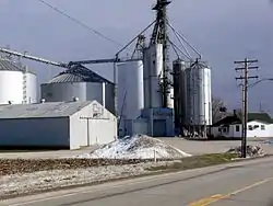 Grain elevator in Troy Grove | |
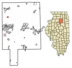 Location in LaSalle County, Illinois | |
.svg.png.webp) Location of Illinois in the United States | |
| Coordinates: 41°27′56″N 89°4′52″W | |
| Country | United States |
| State | Illinois |
| County | LaSalle |
| Township | Troy Grove |
| Incorporated | April 3rd, 1886[1] |
| Area | |
| • Total | 0.69 sq mi (1.78 km2) |
| • Land | 0.69 sq mi (1.78 km2) |
| • Water | 0.00 sq mi (0.00 km2) |
| Elevation | 665 ft (203 m) |
| Population (2010) | |
| • Total | 250 |
| • Estimate (2019)[3] | 238 |
| • Density | 346.43/sq mi (133.79/km2) |
| Time zone | UTC-6 (CST) |
| • Summer (DST) | UTC-5 (CDT) |
| ZIP Code(s) | 61372 |
| Area code(s) | Area codes 815 and 779 |
| FIPS code | 17-76225 |
| Wikimedia Commons | Troy Grove, Illinois |
Troy Grove is notable as the birthplace of Wild Bill Hickok and Kate Austin. It is home to the Wild Bill Hickok Memorial. The town also has another connection to the Wild West, as the last reported wild bison killed in Illinois happened near the town in 1837[5].
Silica sand, a fine white sand used in making glass, is mined in the vicinity of Troy Grove.
History
Originally laid out as Homer, Illinois, the village was named by an early settler who emigrated from Homer, New York.[6] As the town of Homer, Illinois already had a Post Office, the community took its name from a nearby grove, which was named for an early settler.[7] A Post Office has been in operation under the name of Troy Grove since 1837.
In the early 1830's a sawmill was built which facilitated the construction of a new schoolhouse in 1837. The village grew for several years and was home to several shops and businesses. The first store to open was owned by William Alonzo Hickok, father of Wild Bill Hickok. One of the first Presbyterian churches in the county was founded here in 1849 with a congregation of just 8 members. A gristmill was constructed in 1861 [1]
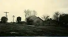
The village was previously served by the Northern Illinois Railroad[1] and the Chicago & Northwestern Railroad. Passenger service was ended in the early 1950's. The railroad is today owned and operated by Union Pacific to haul raw material from the active silica mines.[8]
Geography
Troy Grove is located in northwestern LaSalle County at 41°27′56″N 89°4′52″W (41.465461, -89.081204).[9] U.S. Route 52 passes through the north side of the village as North 37th Road; it leads northwest 8 miles (13 km) to Mendota and east 54 miles (87 km) to Joliet. Interstate 39 passes 1.5 miles (2.4 km) east of the village, with access from Exit 66 (US 52). I-39 leads north 62 miles (100 km) to Rockford and south 7 miles (11 km) to Interstate 80 at LaSalle.
According to the 2010 census, Troy Grove has a total area of 0.69 square miles (1.79 km2), all recorded as land.[10] The Little Vermilion River, a south-flowing tributary of the Illinois River, passes through the southeast corner of the village.
Demographics
| Historical population | |||
|---|---|---|---|
| Census | Pop. | %± | |
| 1880 | 168 | — | |
| 1890 | 283 | 68.5% | |
| 1900 | 316 | 11.7% | |
| 1910 | 289 | −8.5% | |
| 1920 | 261 | −9.7% | |
| 1930 | 259 | −0.8% | |
| 1940 | 233 | −10.0% | |
| 1950 | 258 | 10.7% | |
| 1960 | 271 | 5.0% | |
| 1970 | 281 | 3.7% | |
| 1980 | 297 | 5.7% | |
| 1990 | 259 | −12.8% | |
| 2000 | 305 | 17.8% | |
| 2010 | 250 | −18.0% | |
| 2019 (est.) | 238 | [3] | −4.8% |
| U.S. Decennial Census[11] | |||
As of the census[12] of 2000, there were 305 people, 103 households, and 77 families residing in the village. The population density was 444.2 people per square mile (170.7/km2). There were 108 housing units at an average density of 157.3 per square mile (60.4/km2). The racial makeup of the village was 95.41% White, 1.97% Asian, 0.33% Pacific Islander, 1.31% from other races, and 0.98% from two or more races. Hispanic or Latino of any race were 5.57% of the population.
There were 103 households, out of which 44.7% had children under the age of 18 living with them, 60.2% were married couples living together, 8.7% had a female householder with no husband present, and 24.3% were non-families. 17.5% of all households were made up of individuals, and 4.9% had someone living alone who was 65 years of age or older. The average household size was 2.96 and the average family size was 3.45.
In the village, the population was spread out, with 33.1% under the age of 18, 10.5% from 18 to 24, 27.2% from 25 to 44, 20.3% from 45 to 64, and 8.9% who were 65 years of age or older. The median age was 33 years. For every 100 females, there were 86.0 males. For every 100 females age 18 and over, there were 92.5 males.
The median income for a household in the village was $55,682, and the median income for a family was $56,591. Males had a median income of $40,417 versus $23,250 for females. The per capita income for the village was $16,595. About 6.6% of families and 4.5% of the population were below the poverty line, including 5.8% of those under the age of eighteen and none of those 65 or over.
References
- Kett, H.F. (1877). The Past and present of La Salle County, Illinois : containing a history of the county, its cities, towns, &c., a biographical directory of its citizens, war record of its volunteers in the late rebellion, portraits of early settlers and prominent men, general and local statistics, map of La Salle County, history of Illinois, Constitution of the United States, miscellaneous matters, etc, etc. pp. 347–349.
- "2019 U.S. Gazetteer Files". United States Census Bureau. Retrieved July 14, 2020.
- "Population and Housing Unit Estimates". United States Census Bureau. May 24, 2020. Retrieved May 27, 2020.
- "Profile of General Population and Housing Characteristics: 2010 Census Summary File 1 (DP-1), Troy Grove village, Illinois". American FactFinder. U.S. Census Bureau. Archived from the original on February 13, 2020. Retrieved January 9, 2020.
- https://www.nationalforests.org/get-involved/returning-to-the-prairie-bison-at-midewin
- "LaSalle County". Jim Forte Postal History. Retrieved 30 March 2015.
- Chicago and North Western Railway Company (1908). A History of the Origin of the Place Names Connected with the Chicago & North Western and Chicago, St. Paul, Minneapolis & Omaha Railways. p. 131.
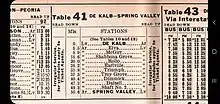
- "1939 C&NW Timetable (Troy Grove listed in table 41)" (PDF). 1939-10-08. Retrieved 2020-10-11.
- "US Gazetteer files: 2010, 2000, and 1990". United States Census Bureau. 2011-02-12. Retrieved 2011-04-23.
- "G001 - Geographic Identifiers - 2010 Census Summary File 1". United States Census Bureau. Archived from the original on 2020-02-13. Retrieved 2015-12-25.
- "Census of Population and Housing". Census.gov. Retrieved June 4, 2015.
- "U.S. Census website". United States Census Bureau. Retrieved 2008-01-31.
Municipalities and communities of LaSalle County, Illinois, United States | ||
|---|---|---|
| Cities | Map of Illinois highlighting LaSalle County | |
| Villages | ||
| Townships |
| |
| CDPs | ||
| Other unincorporated communities | ||
| Ghost towns | ||
| Footnotes | ‡This populated place also has portions in an adjacent county or counties | |
| ||
| Authority control |
|---|