Truyère
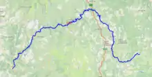
The Truyère (French pronunciation: [tʁy.jɛːʁ]) is a 167-kilometre-long (104 mi) river in south-western France, right tributary of the Lot.[1] Its source is in the south-western Massif Central, north of Mende. It flows generally west through the following départements and towns:
| Truyère | |
|---|---|
 The Truyère in Entraygues-sur-Truyère | |
 | |
| Location | |
| Country | France |
| Physical characteristics | |
| Source | |
| • location | Massif Central |
| • elevation | 1,450 m (4,760 ft) |
| Mouth | |
• location | Lot |
• coordinates | 44°38′37″N 2°33′45″E |
| Length | 167 km (104 mi) |
| Basin size | 3,300 km2 (1,300 sq mi) |
| Discharge | |
| • average | 60 m3/s (2,100 cu ft/s) |
| Basin features | |
| Progression | Lot→ Garonne→ Gironde estuary→ Atlantic Ocean |
| Tributaries | |
| • left | Bès |
| • right | Goul |
The Truyère flows into the Lot in Entraygues-sur-Truyère. Its main tributaries are the Bès near Albaret-le-Comtal, the Goul near Saint-Hippolyte and the Selves near Campouriez.
The Truyère feeds several reservoirs, like the Lac de Grandval and the Lac de Barrage de Sarrans, to supply hydroelectricity.
The Garabit Viaduct, built by Gustave Eiffel, spans the Truyère near Ruynes-en-Margeride.
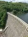 Sarrans hydroelectric dam
 Truyère river and Château d'Alleuze
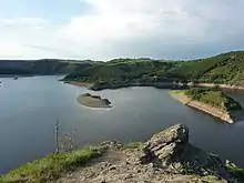 Truyère river at Lac de Grandval
References
This article is issued from Wikipedia. The text is licensed under Creative Commons - Attribution - Sharealike. Additional terms may apply for the media files.
