Campouriez
Campouriez is a commune in the Aveyron department of southern France. It is part of the former province of Rouergue, which utilised the Rouergat dialect of Languedocien Occitan. Inhabitants of Campouriez are called Campouriézois.
Campouriez | |
|---|---|
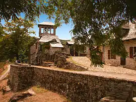 Bes-Bédène in Campouriez | |
.svg.png.webp) Coat of arms | |
Location of Campouriez 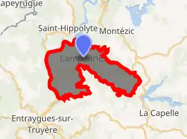
| |
 Campouriez  Campouriez | |
| Coordinates: 44°41′25″N 2°36′26″E | |
| Country | France |
| Region | Occitanie |
| Department | Aveyron |
| Arrondissement | Rodez |
| Canton | Aubrac et Carladez |
| Government | |
| • Mayor (2008–2014) | Gérard Laparra |
| Area 1 | 18.38 km2 (7.10 sq mi) |
| Population (2017-01-01)[1] | 350 |
| • Density | 19/km2 (49/sq mi) |
| Time zone | UTC+01:00 (CET) |
| • Summer (DST) | UTC+02:00 (CEST) |
| INSEE/Postal code | 12048 /12460 |
| Elevation | 226–713 m (741–2,339 ft) (avg. 510 m or 1,670 ft) |
| 1 French Land Register data, which excludes lakes, ponds, glaciers > 1 km2 (0.386 sq mi or 247 acres) and river estuaries. | |
Geography
The territory of this commune takes up a portion of the central-southern area of the Massif central, on the Viadène plateau and near the gorge of the Truyère and the valley of the Lot River. The village is located on a hilltop, and is surrounded by the hamlets la Vaysse, la Joanie, le Bruel, Nigole, Banhars and especially Bez-Bédène.
History
The name Campouriez comes from "champ d'or," Occitan for "field of gold."
Population
| Year | Pop. | ±% |
|---|---|---|
| 1962 | 490 | — |
| 1968 | 540 | +10.2% |
| 1975 | 512 | −5.2% |
| 1982 | 500 | −2.3% |
| 1990 | 422 | −15.6% |
| 1999 | 393 | −6.9% |
| 2008 | 400 | +1.8% |
See also
References
- "Populations légales 2017". INSEE. Retrieved 6 January 2020.
| Wikimedia Commons has media related to Campouriez. |
| Authority control |
|---|
This article is issued from Wikipedia. The text is licensed under Creative Commons - Attribution - Sharealike. Additional terms may apply for the media files.