Tsushima, Nagasaki
Tsushima (対馬市, Tsushima-shi) is an island city grouped in Nagasaki Prefecture, Japan. It is the only city of Tsushima Subprefecture and it encompasses all of Tsushima Island Archipelago, which lies in the Tsushima Strait north of Nagasaki on the western side of Kyushu, the southernmost mainland island of Japan.
Tsushima
対馬市 | |||||||||||||
|---|---|---|---|---|---|---|---|---|---|---|---|---|---|
A panorama view of downtown Izuhara, Tsushima from Mount Shimizu | |||||||||||||
Flag Seal | |||||||||||||
Location of Tsushima in Nagasaki Prefecture | |||||||||||||
 Tsushima Location in Japan | |||||||||||||
| Coordinates: 34°12′N 129°17′E | |||||||||||||
| Country | Japan | ||||||||||||
| Region | Kyushu | ||||||||||||
| Prefecture | Nagasaki Prefecture | ||||||||||||
| First official recorded | 220 AD | ||||||||||||
| City settled | March 1, 2004 | ||||||||||||
| Government | |||||||||||||
| • Mayor | Takarabe Yasunari | ||||||||||||
| Area | |||||||||||||
| • Total | 708.61 km2 (273.60 sq mi) | ||||||||||||
| Population (March 31, 2017) | |||||||||||||
| • Total | 31,550 | ||||||||||||
| • Density | 45/km2 (120/sq mi) | ||||||||||||
| Time zone | UTC+09:00 (JST) | ||||||||||||
| Website | www | ||||||||||||
| |||||||||||||
As of March 2017, the city has an estimated population of 31,550[1] and a population density of 45 persons per km2. Its total area is 708.61 km2, 17.3% of the area of Nagasaki Prefecture.
History
An Imperial decree in July 1899 established Izuhara, Sasuna, and Shishimi as open ports for trading with the United States and the United Kingdom.[2]
On April 1, 1975, Toyotama Village was promoted to the status of a town. Mine Village was also elevated to the status of a town in the following year.
The modern city of Tsushima was established on March 1, 2004, from the merger of six towns on Tsushima Island: Izuhara, Mitsushima, and Toyotama (all from Shimoagata District), and Mine, Kamiagata, and Kamitsushima (all from Kamiagata District). Both districts were dissolved as a result of this merger.
Geography
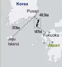
The city of Tsushima is located on Tsushima Island and other small neighbouring islands, lying slightly to the west side of Tsushima Strait, south of the Sea of Japan and north-east of the East China Sea. The island also lies between the Korean Peninsula and the Japanese mainland. Its coastline has a total length of 915 km. Asō Bay, a prominent bay with a rias coastline, is located between the islands. Tsushima lies about 60 km from Iki, 138 km from the city of Fukuoka, and 49.5 km from Busan, South Korea.
Islands
Several other islands encompass Tsushima city, in addition to Kamino-shima and Shimono-shima, both of which makes up the Tsushima Island(s):
- Santsu-jima (三ッ島)
- Shimayama-jima[3] (島山島)
Flora and fauna
Tsushima cat
Native to the island is the Tsushima cat (or Tsushima leopard cat, an endemic subspecies of the leopard cat, Prionailurus bengalensis). Present on the islands since ancient times, its numbers have decreased sharply, and it is now listed as an endangered species. As of 2009, it was estimated that only 80 to 100 animals remain.
Climate
Tsushima has a humid subtropical climate (Köppen climate classification Cfa) with very warm summers and cool winters. Precipitation is significant throughout the year, but is much heavier in summer than in winter.
| Climate data for Izuhara/Tsushima, Nagasaki | |||||||||||||
|---|---|---|---|---|---|---|---|---|---|---|---|---|---|
| Month | Jan | Feb | Mar | Apr | May | Jun | Jul | Aug | Sep | Oct | Nov | Dec | Year |
| Average high °C (°F) | 8.7 (47.7) |
9.4 (48.9) |
12.8 (55.0) |
17.3 (63.1) |
21.4 (70.5) |
23.9 (75.0) |
27.7 (81.9) |
29.3 (84.7) |
25.9 (78.6) |
21.7 (71.1) |
16.5 (61.7) |
11.5 (52.7) |
18.8 (65.9) |
| Daily mean °C (°F) | 4.7 (40.5) |
5.5 (41.9) |
8.7 (47.7) |
13.3 (55.9) |
17.3 (63.1) |
20.5 (68.9) |
24.8 (76.6) |
26.2 (79.2) |
22.5 (72.5) |
17.6 (63.7) |
12.2 (54.0) |
7.2 (45.0) |
15.0 (59.1) |
| Average low °C (°F) | 1.0 (33.8) |
1.8 (35.2) |
4.7 (40.5) |
9.4 (48.9) |
13.3 (55.9) |
17.4 (63.3) |
22.3 (72.1) |
23.5 (74.3) |
19.6 (67.3) |
13.9 (57.0) |
8.3 (46.9) |
3.2 (37.8) |
11.5 (52.8) |
| Average precipitation mm (inches) | 75.5 (2.97) |
92.7 (3.65) |
131.2 (5.17) |
209.9 (8.26) |
199.3 (7.85) |
317.7 (12.51) |
342.7 (13.49) |
242.5 (9.55) |
251.0 (9.88) |
115.5 (4.55) |
106.4 (4.19) |
54.7 (2.15) |
2,139.1 (84.22) |
| Average relative humidity (%) | 62 | 64 | 66 | 72 | 74 | 82 | 85 | 82 | 78 | 71 | 68 | 65 | 72 |
| Mean monthly sunshine hours | 135.6 | 125.8 | 164.6 | 160.1 | 186.2 | 134.9 | 134.3 | 175.8 | 127.0 | 159.6 | 142.9 | 141.7 | 1,788.5 |
| Source: NOAA (1961-1990)[4] | |||||||||||||
Demographics and culture
The population of Tsushima Island has been decreasing significantly. Between the years of 1995 and 2000, the decline was 5.2%.[5] As nuclear families replace the traditional extended families, the average household is smaller, as is the total population.[5] The elderly comprise nearly a quarter of the population here, compared to 20.8% of the Nagasaki Prefecture as a whole, and 17.3% of the population of Japan.[5]
Religious traditions on Tsushima Island mirror those of the rest of Japan, with a majority of the population adhering to Buddhism or Shinto.
| Years | 1975 | 1980 | 1985 | 1990 | 1995 | 2000 |
|---|---|---|---|---|---|---|
| Total Population | 52,472 | 50,810 | 48,875 | 46,064 | 43,513 | 41,230 |
| Age 0-14 | 14,449 | 12,845 | 11,615 | 10,050 | 8,352 | 6,834 |
| Age 15-64 | 33,028 | 32,528 | 31,376 | 29,264 | 27,145 | 25,001 |
| Age 65 & older | 4,995 | 5,437 | 5,884 | 6,735 | 8,016 | 9,395 |
| Households | 14,760 | 15,176 | 15,232 | 15,164 | 15,169 | 15,038 |
Economy
Many Tsushima residents are employed as fishermen. It is also known for its pearl culture. The natural environment of the Tsushima Islands also contributes to the local tourism industry. Beaches are crowded with tourists in the summer.
Transportation
Airport
Tsushima Airport (TSJ) is approximately 10 km (6.2 mi) northeast of the city.
Sister cities
See also
- History of Japan
- Oei Invasion (応永の外寇)
- Japanese invasions of Korea (1592–1598)
- Battle of Tsushima
- So clan
- Tsushima Fuchu domain
Notes
- "Official website of Tsushima City" (in Japanese). Japan: Tsushima City. Retrieved 25 April 2017.
- US Department of State. (1906). A digest of international law as embodied in diplomatic discussions, treaties and other international agreements (John Bassett Moore, ed.), Vol. 5, p. 759.
- List of Japanese Islands Archived 2016-06-15 at the Wayback Machine
- "Izuhara Climate Normals 1961-1990". National Oceanic and Atmospheric Administration. Retrieved January 6, 2013.
- Info on Tsushima Shi
External links
| Wikimedia Commons has media related to Tsushima. |