Tungurahua Province
Tungurahua (Spanish: Provincia del Tungurahua, literally Province of the Tungurahua; pronounced [tuŋɡuˈɾawa]) is one of the twenty-four provinces of Ecuador. Its capital is Ambato. The province takes its name from the Tungurahua volcano, which is located within the boundaries of the provinces.
Tungurahua | |
|---|---|
Province | |
| Province of Tungurahua | |
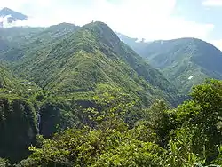 Landscape near Baños | |
 Flag | |
.svg.png.webp) Tungurahua Province in Ecuador | |
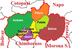 Cantons of Tungurahua Province | |
| Coordinates: 1°14′S 78°37′W | |
| Country | Ecuador |
| Capital | Ambato |
| Cantons | List of cantons
|
| Government | |
| • Provincial Prefect | Fernando Naranjo (Unidad Intercultural) |
| Area | |
| • Total | 3,386.25 km2 (1,307.44 sq mi) |
| Elevation | 2,600 m (8,500 ft) |
| Highest elevation | 5,016 m (16,457 ft) |
| Lowest elevation | 900 m (3,000 ft) |
| Population (2011)INEC decadal national census | |
| • Total | 581,389 |
| • Density | 170/km2 (440/sq mi) |
| Time zone | UTC-5 (ECT) |
| Vehicle registration | T |
| HDI (2017) | 0.768[1] high · 4th |
| Website | www |
Population
In 2011, Tungurahua had an estimated population of 581,389.[2] Approximately 10% of that population is made up of indigenous peoples, while another 70% are of mestizo or mixed race heritage. The final 20% is made up of peoples of African, Asian, and European ancestry.
Climate
The province has a dry, temperate climate. Like all mountainous areas, the region experiences the phenomenon known as microclimates, in which small portions of the province have drastically different conditions from others due to winds and area pressure.
Generally though, Tungurahua experiences temperatures between 14 and 17 degree Celsius in the day-time, with cooler nights. At higher altitudes, conditions are much colder. Despite the area being near the Equator, mountains such as Carihuayrazo and Chimborazo are covered in snow for much of the year.[3]
Geography
The province is very mountainous, containing the Tungurahua volcano near Baños, as well as bordering the Carihuayrazo and Chimborazo volcanoes to the south. Baños attracts the highest number of tourists. The principal river of the province is the Patate River, which flows to the east toward the Amazon Region.[4]
Political division
The province is divided into nine cantons which stretch from Ambato in the west to Baños in the east. The following table lists each with its population at the 2001 census, its area in square kilometres (km²), and the name of the canton seat or capital.[5]
| Canton | Pop. (2011) | Area (km²) | Seat/Capital |
|---|---|---|---|
| Ambato | 387,282 | 1,009 | Ambato (San Juan de Ambato) |
| Baños | 19,112 | 1,065 | Baños (Baños de Agua Santa) |
| Cevallos | 8,873 | 19 | Cevallos |
| Mocha | 8,371 | 86 | Mocha |
| Patate | 16,771 | 315 | Patate |
| Pelileo | 58,988 | 202 | Pelileo (San Pedro de Pelileo) |
| Píllaro | 44,925 | 443 | Píllaro (Santiago de Píllaro) |
| Quero | 23,187 | 173 | Quero (Santiago de Quero) |
| Tisaleo | 14,525 | 59 | Tisaleo |
Places of interest
- Parque de la Familia
- Llanganates National Park
See also
External links
References
- Villalba, Juan. "Human Development Index in Ecuador". Scribd (in Spanish). Retrieved 2019-02-05.
- Population of the Honorable Consejo Provincial de Tungurahua Archived 2009-04-12 at the Wayback Machine. 21 July 2009.
- Territory of the Honorable Consejo Provincial de Tungurahua Archived 2009-08-28 at the Wayback Machine. 21 July 2009.
- Population of the Honorable Consejo Provincial de Tungurahua Archived 2009-04-12 at the Wayback Machine. 21 July 2009.
- Cantons of Ecuador. Statoids.com. Retrieved 4 November 2009.