Tuningen
Tuningen is a Gemeinde (municipality) located in the Schwarzwald-Baar district in the middle of Baden-Württemberg, Germany.
Tuningen | |
|---|---|
 Coat of arms | |
Location of Tuningen within Schwarzwald-Baar-Kreis district 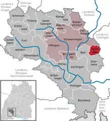 | |
 Tuningen  Tuningen | |
| Coordinates: 48°01′36″N 8°36′07″E | |
| Country | Germany |
| State | Baden-Württemberg |
| Admin. region | Freiburg |
| District | Schwarzwald-Baar-Kreis |
| Municipal assoc. | Villingen-Schwenningen |
| Government | |
| • Mayor | Jürgen Roth |
| Area | |
| • Total | 15.59 km2 (6.02 sq mi) |
| Elevation | 743 m (2,438 ft) |
| Population (2019-12-31)[1] | |
| • Total | 2,933 |
| • Density | 190/km2 (490/sq mi) |
| Time zone | UTC+01:00 (CET) |
| • Summer (DST) | UTC+02:00 (CEST) |
| Postal codes | 78609 |
| Dialling codes | 07464 |
| Vehicle registration | VS |
| Website | www.tuningen.de |
The municipality belongs to the administrative authority (Verwaltungsgemeinschaft) of Villingen-Schwenningen.
Geography
Tuningen is located at the east border of the Black Forest about 14 km south-east of the district town Villingen-Schwenningen, 6 km east of Bad Dürrheim and 5 km south-west of Trossingen.
History
The first explicit reference to Tuningen dates to 797, in a deed of donation by the cloister St. Gallen.
Twin towns
 Camogli, Italy, since 1998
References
- "Bevölkerung nach Nationalität und Geschlecht am 31. Dezember 2019". Statistisches Landesamt Baden-Württemberg (in German). September 2020.
External links
| Authority control |
|---|
This article is issued from Wikipedia. The text is licensed under Creative Commons - Attribution - Sharealike. Additional terms may apply for the media files.