Tweeling
Tweeling (meaning twin in Dutch and Afrikaans) is a small town situated 22 km from Frankfort in the Free State province of South Africa. The adjacent black township is named Mafahlaneng, or "place of twins". This region of the highveld is colloquially known as the Riemland, recalling a time when it was a favoured hunting ground of the early pioneers.
Tweeling
Mafahlaneng | |
|---|---|
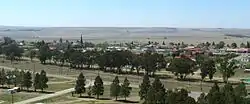 View of Tweeling | |
 Tweeling  Tweeling | |
| Coordinates: 27°33′S 28°31′E | |
| Country | South Africa |
| Province | Free State |
| District | Fezile Dabi |
| Municipality | Mafube |
| Area | |
| • Total | 4.6 km2 (1.8 sq mi) |
| Elevation | 1,600 m (5,200 ft) |
| Population (2011)[1] | |
| • Total | 6,465 |
| • Density | 1,400/km2 (3,600/sq mi) |
| Racial makeup (2011) | |
| • Black African | 93.9% |
| • Coloured | 1.7% |
| • Indian/Asian | 0.4% |
| • White | 3.8% |
| • Other | 0.1% |
| First languages (2011) | |
| • Sotho | 76.1% |
| • Zulu | 13.8% |
| • Afrikaans | 6.1% |
| • Sign language | 1.5% |
| • Other | 2.6% |
| Time zone | UTC+2 (SAST) |
| Postal code (street) | 9820 |
| PO box | 9820 |
| Area code | 058 |
The town was established in 1920 on the two farms Tweelingspruit and Tweelingkop, their names derived from two similar looking hills just outside the town. It is situated just east of the Liebenbergsvlei River which is a conduit for water from the Lesotho Highlands Water Project.
Tweeling is the halfway mark of the annual Liebensbergvlei Canoe Marathon. The two day race starts near Reitz and halts 33 km downstream at Zorgvliet farm, near Tweeling. The second stage starts from Bruinswick farm north of town and ends at Frankfort.
People from Tweeling
- Johan Heyns, theologian
- Sisi Ntombela, politician and 6th premier of the Free State
Gallery
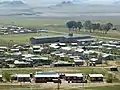 Refeng Thabo High School in Mafahlaneng township
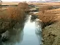 Liebenbergsvlei River north of town
References
- Sum of the Main Places Mafahlaneng and Tweeling from Census 2011.
![]() Media related to Tweeling at Wikimedia Commons
Media related to Tweeling at Wikimedia Commons
External links
[Dabulamanzi.co.za/liebenbergsvlei/|[[https://dabulamanzi.co.za/liebenbergsvlei/]
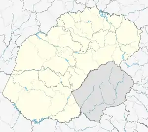
Municipalities and communities of Fezile Dabi District Municipality, Free State | ||
|---|---|---|
District seat: Sasolburg | ||
| Moqhaka | .svg.png.webp) Fezile Dabi District within South Africa | |
| Ngwathe | ||
| Metsimaholo | ||
| Mafube | ||