Typhoon Alice (1953)
Typhoon Alice was a typhoon that brought severe flooding to Guam during the latter part of the 1953 Pacific typhoon season. The system was first tracked near the Marshall Islands on October 11 by the Joint Typhoon Warning Center (JTWC) as a tropical storm, and the Japan Meteorological Agency (JMA) as a tropical depression. The JMA upgraded Alice to a tropical storm east of Guam on October 14. One day later, and the JTWC reported that the storm had intensified to 65 knots (75 mph; 120 km/h), equivalent to a Category 1 typhoon on the Saffir–Simpson scale. Near Iwo Jima, the typhoon traveled northeastwards, reaching its peak of 100 kn (115 mph; 185 km/h) late on October 18. Alice then steadily weakened down to a tropical storm on October 20. The storm became extratropical on October 23 near the International Date Line, and both agencies ceased tracking the cyclone.
| Category 3 typhoon (SSHWS) | |
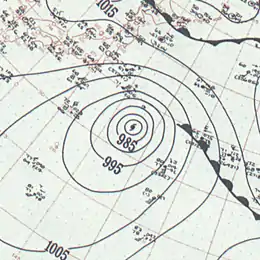 Surface analysis of Typhoon Alice on October 19 | |
| Formed | October 11, 1953 |
|---|---|
| Dissipated | October 23, 1953 |
| Highest winds | 1-minute sustained: 185 km/h (115 mph) |
| Lowest pressure | 915 hPa (mbar); 27.02 inHg |
| Fatalities | 3 direct, 1 indirect |
| Damage | > $100,000 (1953 USD) |
| Areas affected | Guam, Iwo Jima |
| Part of the 1953 Pacific typhoon season | |
As the typhoon moved near Guam from October 14 to October 16, 18.33 inches (46.6 cm) of rain fell within 24 hours, at the time a record for the territory. Villages on the island had homes and businesses flooded, causing thousands of dollars of damage. Several bridges were washed away, causing of three of the deaths. Andersen Air Force Base suffered from flooding, but military installations were not heavily damaged. Damage totals on the island exceed $100,000 (1953 USD). Little damage was reported in Iwo Jima, where Alice moved to the east of the island.
Meteorological history

The Joint Typhoon Warning Center (JTWC) and the Japan Meteorological Agency (JMA) began tracking a system west of the Marshall Islands at 12:00 UTC on October 11.[1][nb 1] The JTWC tracked the system as a tropical storm with winds of 35 knots (40 mph; 65 km/h),[3] and the JMA as a tropical depression with a pressure reading of 1,006 hectopascals (29.7 inHg).[4] The system strengthened slowly as it moved west-northwestward,[1] with the JMA reporting Alice had strengthened to a tropical storm near Guam at 00:00 UTC on October 14, with a barometric pressure of 1,000 hPa (30 inHg).[4] At that time, the JTWC had reported winds of 45 kn (50 mph; 85 km/h).[3] Alice began to slow down near Guam,[5] strengthening to 75 kn (85 mph; 140 km/h) at 00:00 UTC one day later,[3] equivalent to a Category 1 typhoon on the Saffir–Simpson scale. After October 15, Alice began to travel northwestwards and continued to intensify.[1] At 06:00 UTC on October 16, the typhoon had strengthened to 85 kn (100 mph; 155 km/h),[3] with a pressure reading of 979 hPa (28.9 inHg).[4] On October 17, the storm turned northeastward,[1] with the JTWC reporting winds of 90 kn (105 mph; 165 km/h).[3] At 18:00 UTC, the JMA reported Alice's lowest barometric pressure at 915 hPa (27.0 inHg).[4]
The highest maximum sustained winds of the typhoon, 100 kn (115 mph; 185 km/h), equivalent to a Category 3 on the Saffir–Simpson scale, were recorded at 18:00 UTC on October 19 near Iwo Jima by the 56th Weather Reconnaissance Squadron.[3][6] JMA had recorded a pressure of 920 hPa (27 inHg) at that time.[4] According to an analysis of the historic western north Pacific tropical cyclone record in the Monthly Weather Review, it was likely that stronger winds existed near the eye, but were not observed.[7] Alice began to steadily weaken later that day to 75 kn (85 mph; 140 km/h) by October 20.[3] At 18:00 UTC, the system had weakened below typhoon strength to a tropical storm with sustained winds of 60 kn (70 mph; 110 km/h), as it turned east and accelerated away from Japan.[1] Alice traveled near the International Date Line (IDL) and had weakened to 35 kn (40 mph; 65 km/h) at 18:00 UTC of October 22 according to the JTWC.[3] The JMA declared the storm to be extratropical six hours later, as it traveled past the IDL.[4] The cyclone began to restrengthen up to 60 kn (69 mph; 110 km/h) by 12:00 UTC of October 23, when the JTWC ceased tracking.[3]
Preparations and impact
The storm was not expected to strengthen near Guam,[8] and personnel at the Andersen Air Force Base were told to remain in shelter. Reconnaissance flights were not able to take flight from the air force base, and flights were completed from Tokyo instead.[9] Shipping, including reefer ships, to Guam were delayed.[10]
Alice moved slowly to the north of Guam from October 14 to October 16, only moving 270 miles (430 km) during that time, causing significant flooding. During a 48-hour period, Andersen Air Force Base and Naval Air Station Agana received 32.51 inches (826 mm) and 21.21 in (539 mm) of rain respectively. The 24-hour rainfall total at Andersen Air Base, 18.33 in (466 mm), was the record high in Guam until Typhoon Pamela of 1976 struck the island. A peak wind gust of 56 kn (64 mph; 104 km/h) and a minimum atmospheric pressure of 1,001 mbar (29.6 inHg) were also recorded on the island.[5] The resulting floods washed away four bridges across the island, cutting off access to the villages of Talofofo, Inarajan, Merizo, and Umatac. Floodwaters at Tamuning reached 3 to 4 feet (0.91 to 1.22 m) high. Electricity was shut off in areas with flooding issues, and a boil-water advisory was in effect.[8] Multiple roads, including Highways 4 and 8, were rendered impassable, and Marine Drive had debris floating and stalled cars alongside it.[9]
Many homes and businesses across the island were damaged by the floods. Thousands of dollars of merchandise and properties were ruined, causing stores to close down for repairs. Government offices were also closed or on stand-by except public works and the police departments. Access to the Navy commissary was blocked by waters that were up to 5 to 7 feet (1.5 to 2.1 m) high. Water leaked into the Guam Memorial Hospital, prompting doctors and nurses to move patients and supplies to dryer areas.[9] Residents in Yigo, Tamuning, and Asan had floodwaters damage their homes, causing some to evacuate.[8] Much of Andersen Air Force Base was flooded,[9] and two airmen were electrocuted when they were leaning against a metal doorknob at The Airman's Club.[8] Naval installations at the base had minor water damage,[9] and operations returned to normal one day later.[11] Four deaths were reported during the storm. Two of them were airmen attempting to cross the Talofofo River when the bridge washed away. A search party was initiated, but it was later called off as no bodies were found.[10] One of the bodies was found near Dealy Beach and Togcha on October 19.[12] The third casualty was a Filipino firefighter who had also attempted to cross the river, with his body found 500 yards (460 m) from the bridge.[10] The fourth death was a farmer dying from a heart attack in his pasture during the storm; he had been previously reported as drowned.[11] Property damage totals exceeded $100,000 (equivalent to $955,597 in 2019).[5] Ford Quint Elvidge, the Governor of Guam, toured the island and inspected the damage, praising the government agencies for their efforts.[9]
As Alice passed 100 mi (160 km) east of Iwo Jima on October 19, light rainfall of 1.5 in (38 mm) and winds of 70 mph (110 km/h) were reported on the island.[6]
Notes
- The Japan Meteorological Agency is the official Regional Specialized Meteorological Center for the western Pacific Ocean.[2]
References
- Knapp, Kenneth R.; Diamond, Howard J.; Kossin, James P.; Kruk, Michael C.; Schreck, Carl J. III (2018). 1953 Super Typhoon ALICE (1953285N09161). International Best Track Archive for Climate Stewardship (IBTrACS) Project, Version 4. (Report). NOAA National Centers for Environmental Information. doi:10.25921/82ty-9e16. Retrieved November 19, 2020 – via University of North Carolina at Asheville.
- Annual Report on Activities of the RSMC Tokyo – Typhoon Center 2000 (PDF) (Report). Japan Meteorological Agency. February 2001. p. 3. Archived (PDF) from the original on October 31, 2015. Retrieved November 19, 2020.
- "Typhoon Alice (19W) Best Track". Joint Typhoon Warning Center. Retrieved November 19, 2020.
- "RSMC Best Track Data (Text)". Japan Meteorological Agency. 1951–1959. Retrieved November 19, 2020.
- Weir, Robert C. (September 1, 1983). Tropical Cyclones Affecting Guam (1671-1980) (PDF) (Report). Joint Typhoon Warning Center. pp. 25, 39, 45. Retrieved November 19, 2020.
- "Typhoon Alice To Miss Tokyo, Iwo Gets Storm". Pacific Stars and Stripes. Tokyo. October 19, 1953. p. 6. Retrieved November 19, 2020 – via NewspaperARCHIVE.

- Knapp, Kenneth R.; Knaff, John A.; Sampson, Charles R.; Riggio, Gustavo M.; Schnapp, Adam D. (August 2013). "A Pressure-Based Analysis of the Historical Western North Pacific Tropical Cyclone Intensity Record". Monthly Weather Review. American Meteorological Society. 141 (8): 2611–2631. doi:10.1175/MWR-D-12-00323.1.
- "Lightning Burns Two; Unexpected Typhoon Dumps 19 Inches Rain". Guam Daily News. Agana Heights, Guam. October 16, 1953. p. 1. Retrieved November 19, 2020 – via Newspapers.com.
- "One Dead In Storm; Property Loss Heavy". Guam Daily News. Agana Heights, Guam. October 16, 1953. p. 2. Retrieved November 19, 2020 – via Newspapers.com.
- "Two Airmen, Civilian Lost Attempting To Cross Talofofo River". Guam Daily News. Agana Heights, Guam. October 17, 1953. p. 1. Retrieved November 19, 2020 – via Newspapers.com.
- "Three Men Drown In Talofofo River". Guam Daily News. Agana Heights, Guam. October 17, 1953. p. 2. Retrieved November 19, 2020 – via Newspapers.com.
- "Body Of Talofofo Flood Victim Found". Guam Daily News. Agana Heights, Guam. October 19, 1953. p. 1. Retrieved November 19, 2020 – via Newspapers.com.