Merizo, Guam
Merizo (Chamorro: Malesso), is the southernmost village in the United States territory of Guam. Cocos Island (Chamorro: Islan Dåno) is a part of the municipality. The village's population has decreased since the island's 2000 census.[2]
Merizo Malesso | |
|---|---|
 Flag | |
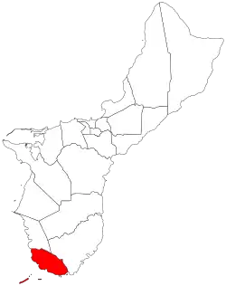 Location of Merizo within the Territory of Guam. | |
| Country | United States |
| Territory | Guam |
| Government | |
| • Mayor | Ernest T. Chargualaf (R) |
| Population (2010)[1] | |
| • Total | 1,850 |
| Time zone | UTC+10 (ChST) |
History
| Historical population | |||
|---|---|---|---|
| Census | Pop. | %± | |
| 1960 | 1,398 | — | |
| 1970 | 1,529 | 9.4% | |
| 1980 | 1,663 | 8.8% | |
| 1990 | 1,742 | 4.8% | |
| 2000 | 2,163 | 24.2% | |
| 2010 | 1,850 | −14.5% | |
| Source:[1] | |||
During the first Spanish missionary efforts on Guam, Merizo was the site of resistance encouraged by Choco, a Chinese resident of the village. The parish of Merizo was the second established by the Spanish on Guam. A large population of Chamorros from the Mariana Islands were relocated to the village during Spanish rule.[3]
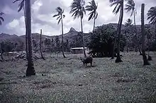
The village covers an area of 6 square miles (16 km2) and is located on the shore below the volcanic hills of southern Guam. Places of interest for visitors include Merizo Bell Tower, Malesso Kombento and Merizo Pier where ferries can be taken to Cocos Island (Guam) Resort. Several popular dive sites are located off Merizo's coast.
Contamination of lagoon
Officials from the Guam Environmental Protection Agency, Department of Public Health and Social Services and the Coast Guard announced findings of major polychlorinated biphenyl (PCB) contamination in the Cocos Lagoon on February 20, 2006 and warned people not to eat fish caught there. The contamination is believed to have come from a United States Coast Guard station which operated on Cocos Island from 1944-1963.
Climate
| Climate data for Merizo, Guam | |||||||||||||
|---|---|---|---|---|---|---|---|---|---|---|---|---|---|
| Month | Jan | Feb | Mar | Apr | May | Jun | Jul | Aug | Sep | Oct | Nov | Dec | Year |
| Average high °F (°C) | 87.0 (30.6) |
86.4 (30.2) |
86.7 (30.4) |
87.1 (30.6) |
87.6 (30.9) |
87.2 (30.7) |
87.7 (30.9) |
87.4 (30.8) |
87.8 (31.0) |
88.3 (31.3) |
88.3 (31.3) |
87.7 (30.9) |
87.4 (30.8) |
| Average low °F (°C) | 75.9 (24.4) |
76.2 (24.6) |
76.4 (24.7) |
76.4 (24.7) |
76.1 (24.5) |
76.0 (24.4) |
75.0 (23.9) |
74.3 (23.5) |
74.7 (23.7) |
74.5 (23.6) |
75.8 (24.3) |
75.3 (24.1) |
75.6 (24.2) |
| Average precipitation inches (mm) | 8.6 (220) |
8.8 (220) |
8.2 (210) |
10.9 (280) |
11.3 (290) |
12.8 (330) |
12.4 (310) |
15.1 (380) |
13.1 (330) |
10.7 (270) |
11.1 (280) |
11.0 (280) |
134 (3,400) |
| Source: Weatherbase [4] | |||||||||||||
Demographics
The U.S. Census Bureau has the Merizo census-designated place.[5]
Education
Public schools
Guam Public School System serves the island.
Merizo Martyrs Elementary School in Merizo and Inarajan Middle School in Inarajan serve Merizo.[6]
Southern High School in Santa Rita serves the village.[7]
Public libraries
Guam Public Library System operates the Merizo Library at 376 Cruz Avenue.[8]
Recreation
Water sport crafts can be rented near Merizo Pier. The pier is also a great fishing spot.
Mayor of Merizo
| Commisioner of Mangilao | |||
| Name | Term begin | Term end | |
|---|---|---|---|
| Francisco C. Chargualaf | 1957 | 1977 | |
| Joaquin Q. Acfalle | 1977 | 1979 | |
| Ignacio "Buck" S. Cruz | 1979 | 1981 | |
| Jose R. Tyquiengco | 1981 | 1985 | |
| Mayor of Mangilao | |||
| Name | Party | Term begin | Term end |
|---|---|---|---|
| Ignacio "Buck" S. Cruz | Democratic | January 7, 1986 | January 1, 2001 |
| Rita A. Tainatongo | Republican | January 1, 2001 | September 2006 |
| Sherry L. Chargualaf | September 2006 | January 5, 2009 | |
| Ernest T. Chargualaf | Democratic | January 5, 2009 | present |
References
- "2010 Guam Statistical Yearbook" (PDF). Archived from the original (PDF) on 2014-07-23. (4.3 MB), (rev. 2011)
- Therese Hart, "Guam Population slightly up, latest census says," Marianas Variety, August 26, 2011, http://mvguam.com/index.php?option=com_content&view=article&id=19623:guam-population-slightly-up-latest-census-says&catid=59:frontpagenews Archived 2016-01-26 at the Wayback Machine
- Geert Cole, "South Pacific and Micronesia", Lonely Planet Books, 2006, P.161-165, ISBN 978-1741043044.
- "Weatherbase: Historical Weather for Merizo, Guam". Weatherbase. 2011. Retrieved on November 24, 2011.
- "2010 CENSUS - CENSUS BLOCK MAP: Merizo CDP, GU" (PDF). U.S. Census Bureau. Retrieved 2020-10-09. - See "Merizo muny"
- https://web.archive.org/web/20060222192437/http://www.lk4kids.com/school%2Blinks.htm
- "Guam's Public High Schools." Guam Public School System. Accessed September 8, 2008.
- http://gpls.guam.gov/Portals/50/GPLS_LOC/GPLS_Location_2007Apr12.xml%5B%5D
- Rogers, Robert F (1995). Destiny's Landfall: A History of Guam: University of Hawai'i Press. ISBN 0-8248-1678-1
- Carter, Lee D; Carter, Rosa Roberto; Wuerch, William L (1997). Guam History: Perspectives Volume One: MARC. ISBN 1-878453-28-9
- Sanchez, Pedro C. Guahan, Guam: The History of our Island: Sanchez Publishing House.
External links
Hagåtña (capital) | |
| Topics | |
| Islands | |
| Villages | |
| Peaks |
|
| Healthcare | |