Inarajan, Guam
Inarajan (Chamorro: Inalåhan) is a village located on the southeastern coast of the United States territory of Guam. The village's original Chamoru name, Inalåhan, was altered when transliterated during Spanish control of the island.
Inarajan Inalåjan | |
|---|---|
 Flag | |
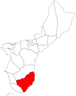 Location of Inarajan within the Territory of Guam. | |
| Country | United States |
| Territory | Guam |
| Government | |
| • Mayor | Doris Flores Lujan (D) |
| Population (2010)[1] | |
| • Total | 2,273 |
| Time zone | UTC+10 (ChST) |
Inarajan Village | |
 | |
| Location | Rte. 4 |
| Area | 49 acres (20 ha) |
| Built | 1901 |
| Architect | Cruz, Jose Duena; Luttrull, A.I. |
| NRHP reference No. | 77001569[2] |
| Added to NRHP | November 7, 1977 |
| Historical population | |||
|---|---|---|---|
| Census | Pop. | %± | |
| 1960 | 1,730 | — | |
| 1970 | 1,897 | 9.7% | |
| 1980 | 2,059 | 8.5% | |
| 1990 | 2,469 | 19.9% | |
| 2000 | 3,052 | 23.6% | |
| 2010 | 2,273 | −25.5% | |
| Source:[1] | |||
History
The village history predates the 1521 discovery of Guam by the Spanish. It was the home to the legendary Chief Gadao, and was one of the few villages with sizable populations at the end of Spanish rule in 1898. In 1950 it had a population of 1,494 with 814 living in the village itself. Today, it is the best preserved of the Spanish era villages and is known for its rich history and culture, and has been listed on the National Register of Historic Places. The village's population has decreased since the island's 2000 census.[3]
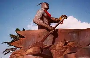
Places of interest include the village's pre-World War II church, statue of Chief Gadao, the Gef Pa'go Chamorro Village, the ancient Paintings of Chief Gadao's Cave, and historic village architecture.
The municipality of Inarajan includes the community of Malojloj, in the hills north of the central village. Malojloj and Inarajan each celebrate separate village fiestas. Many residents from the Malojloj section of Inalahan, claim themselves to be a separate village, seeing as they celebrate different fiestas and they have their own land boundary. In Southern Guam, it is easily recognisable as to what part is proper to Inalahan, and what is proper to Malojloj.
The Dandan region of Malojloj was the site of a NASA Apollo tracking station and is the current the site of the Layon Municipal Sanitary Landfill for Guam replacing the Ordot Landfill. The Landfill was opposed immensely by the residents of the village as well as many environmentalists, but the government of Guam overruled them.[4]
Demographics
The U.S. Census Bureau counts the following census-designated places in Inarajan: Inarajan,[5] and Malojloj.[6]
Education
Guam Public School System serves the island.
Inarajan Elementary School and Inarajan Middle School are in Inarajan. Southern High School in Santa Rita serves the village.[7]
Inarajan High School, formerly located in Inarajan, closed in 1997.[8]
Notable residents
- Former Vice Speaker David L.G. Shimizu
Government
| Name | Party | Term begin | Term end | Notes |
|---|---|---|---|---|
| Mayor of Inarajan | ||||
| Jamie D.S. Paulino | Democratic | January 5, 1981 | 1988 | Late honorable Jaime D.S Paulino served as president of Mayor's Council of Guam. He was also a survivor of the Japanese occupation of Guam and once the chairman of the Democratic Party of Guam. |
| Edward C. Crisostomo | N/A | 1988 | 1988 | He was appointed by Governor of Guam |
| Eddie C. Paulino | 1988 | January 2, 1989 | ||
| Juan C. Cruz | Republican | January 2, 1989 | January 4, 1993 | |
| Jesse L.G. Perez | Democratic | January 4, 1993 | January 1, 2001 | |
| Franklin M. Taitague | Republican | January 1, 2001 | January 7, 2013 | |
| Doris F. Lujan | Democratic | January 7, 2013 | January 4, 2021 | Election in office.[9] |
| Anthony P. Chargualaf Jr. | January 4, 2021 | present | ||
References
- "2010 Guam Statistical Yearbook" (PDF). Archived from the original (PDF) on 2014-07-23. (4.3 MB), (rev. 2011)
- "National Register Information System". National Register of Historic Places. National Park Service. July 9, 2010.
- Therese Hart, "Guam Population slightly up, latest census says," Marianas Variety, August 26, 2011, http://mvguam.com/index.php?option=com_content&view=article&id=19623:guam-population-slightly-up-latest-census-says&catid=59:frontpagenews
- Author unknown, "Opinions mixed on GRRP's landfill plans", KUAM April 2, 2009, http://www.kuam.com/story/11218519/opinions-mixed-on-grrps-landfill-plans
- "2010 CENSUS - CENSUS BLOCK MAP: Inarajan CDP, GU" (PDF). U.S. Census Bureau. Retrieved 2020-10-09. - See "Inarajan muny"
- "2010 CENSUS - CENSUS BLOCK MAP: Malojloj CDP, GU" (PDF). U.S. Census Bureau. Retrieved 2020-10-09. - See "Inarajan muny"
- "Guam's Public High Schools." Guam Public School System. Accessed September 8, 2008.
- http://www.gdoe.net/rpe/annual_grad_ratesSY96_02.htm
- Guam Election Commission, Official 2012 General Election Results Archived 2016-12-30 at the Wayback Machine, Hagatna, 2013.
- Rogers, Robert F (1995). Destiny's Landfall: A History of Guam: University of Hawai'i Press. ISBN 0-8248-1678-1
External links
| Wikimedia Commons has media related to Inarajan, Guam. |
- Inarajan Guam at Guam Portal
- Pacific Worlds, 2003
- Inarajan Map from PDN
Hagåtña (capital) | |
| Topics | |
| Islands | |
| Villages | |
| Peaks |
|
| Healthcare | |