Typhoon Haishen (2020)
Typhoon Haishen, known in the Philippines as Typhoon Kristine, was a powerful tropical cyclone that became the first super typhoon of the 2020 Pacific typhoon season. Being also the tenth named storm and this season's fifth typhoon, Haishen's origins can be tracked back to a disorganised low pressure area situated near Guam. While the disturbance tracked south-westward and quickly organised, the JTWC issued a Tropical Cyclone Formation Alert (TCFA) on the system, and a day later, on September 1, the system became a tropical depression.[1] The depression strengthened into Tropical Storm Haishen according to the Japan Meteorological Agency as it moved southwestward.[2] At about 12:00 UTC on September 2, the Philippine Atmospheric, Geological and Astronomical Services Administration indicated that Haishen had entered the Philippine Area of Responsibility and was subsequently named Kristine.[3][4] Later that day, Haishen became a typhoon. Intensification on September 3 was significant. Drifting northwestward into extremely favorable conditions, Haishen became a category 3-equivalent typhoon, acquiring a pinhole eye, before undergoing an eyewall replacement cycle (EWRC). Strengthening resumed soon after and the JTWC assessed wind speeds of 135 kt (155 mph; 250 km/h) as it peaked as a powerful Category 4 super typhoon and had attained a new, symmetrical, clear eye.[5][6]
| Typhoon (JMA scale) | |
|---|---|
| Category 4 super typhoon (SSHWS) | |
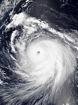 Typhoon Haishen near peak intensity on September 4 | |
| Formed | August 30, 2020 |
| Dissipated | September 10, 2020 |
| (Extratropical after September 7) | |
| Highest winds | 10-minute sustained: 195 km/h (120 mph) 1-minute sustained: 250 km/h (155 mph) |
| Lowest pressure | 910 hPa (mbar); 26.87 inHg |
| Fatalities | 4 total, 6 missing |
| Damage | > $100 million (2020 USD) |
| Areas affected | |
| Part of the 2020 Pacific typhoon season | |
Traversing northward toward land while gaining latitude, ocean heat content became unfavorable for supporting such a strong system, and while the central pressure decreased, the system's wind speeds began decreasing, as the structure began degrading. The eye's former shape was no longer present as it appeared ragged on satellite imagery, and Dvorak analysis indicated that Haishen was beginning to weaken steadily. On September 5, Haishen began to lose its eye as its inner eyewall began contracting, and it subsequently weakened to a category 3-equivalent typhoon.[7] On September 6, Haishen made landfall on Japan and South Korea as a strong category 2-equivalent typhoon.[8]
Haishen was the third typhoon within a span of two weeks to make landfall in the Korean Peninsula, the others being Bavi and Maysak.
Meteorological history
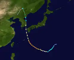
On August 29, the JTWC began tracking a very disorganized tropical disturbance situated a couple hundred miles northeast of Guam. By the next day, the disturbance had quickly organized, and the JTWC issued a Tropical Cyclone Formation Alert (TCFA) for the low-pressure area,[9] and by the next day, it intensified into Tropical Depression 11W.[10] Traversing generally south-westward, the depression quickly intensified into a tropical storm.[11] The JMA soon followed and upgraded the system into a tropical storm as well, and was given the international name Haishen. Later that day, Haishen became a severe tropical storm as it headed southwest into the Philippine Sea. Intensification on September 3 was significant - with Typhoon Haishen acquiring a pinhole eye early in the day, but it later underwent an eyewall replacement cycle. The cycle completed quickly, however, and strengthening resumed almost immediately. Then, the JTWC noted the possibility of Haishen becoming a Category 5 super typhoon in one of their advisories.
Entering the Philippine Area of Responsibility (PAR), the Philippine Atmospheric, Geological and Atmospheric Services Administration (PAGASA) named the system Kristine.[12][13] Early on September 4, the JTWC assessed that Haishen became a Category 4-equivalent super typhoon - with 1-minute sustained wind speeds of 135 kt (155 mph; 250 km/h),[14] with a clear, symmetrical eye visible on satellite imagery.[15] On September 5, as Haishen's latitude increased, the ocean heat content in the area decreased,[16] which disrupted the system's core and caused its eye to appear ragged on satellite imagery, subsequently indicating weakening, and dropping below super typhoon status.[17]
Later that day, the system left the PAR and PAGASA issued its last bulletin on the typhoon.[18] As the system continued its northward track toward the Japanese archipelago, it continued to weaken and became a category 3 typhoon as Haishen made another eyewall replacement cycle, and not too long after it dropped to a category 2 typhoon as it neared the Southern Ryukyu Islands of Japan. A mandatory evacuation order was issued for western Japan as millions of people evacuated accordingly.[19] Haishen made landfall in Ulsan, South Korea at around 09:00 KST (00:00 UTC) on September 7,[20] with 10-minute maximum sustained winds at 140 km/h (85 mph) and the central pressure at 955 hPa (28.20 inHg). Shortly after, Haishen entered the Sea of Japan as a high-end tropical storm; due to the low-sea surface temperatures, Haishen quickly weakened and made landfall in the South Hamgyong Province, North Korea with 10-minute maximum sustained winds of 100 km/h (65 mph) and a central pressure of 980 hPa (28.94 inHg).[21] Soon afterwards, JTWC issued its final warning on Haishen, as it moved further inland into North Korea.[22] At 18:50 UTC, JMA issued its last advisory on Haishen, and declared it an extratropical low as it moved near the China–North Korea border.[21]
Preparations
Japan
Officials ordered people to evacuate from dangerous areas near the coast and follow orders by local governments. Authorities urged evacuation for more than 100,000 households in the southern prefectures of Okinawa, Kagoshima, Kumamoto, and Nagasaki before the storm, according to the Fire and Disaster Management Agency.[23] There is a potential danger of flooding in Kyushu; and more than 500 flights were cancelled to southern Kyushu and Okinawa due to the hazardous conditions.[24]
South Korea
Over 340 flights and 114 shipping routes, in addition to several national train services, were cancelled.[25]
North Korea
Residents in coastal Kangwon Province were evacuated and flood warnings were issued ahead of the storm.[25]
Impact
At least four casualties were reported, with two in Japan and another two in South Korea. The storm caused notable flood and wind-related damage and major power outages. Around 10,000 houses were damaged, destroyed or flooded in storm-related incidents. Total combined economic losses are anticipated to surpass US$100 million.[26]
Japan
Haishen brought strong winds and high waves to parts of Japan.[23] At least two people were killed and over 100 were injured.[27] A mudslide in Miyazaki Prefecture left four people missing.[25] Agricultural damage across the nation were at JP¥12.51 billion (US$118 million).[28]
South Korea
Flooding rains and strong winds from Haishen displaced 3,100 people and left at least 75,000 households without power. Two people were killed and five were injured; two others went missing.[25] Two nuclear power plants in Gyeongju automatically stopped during the typhoon for yet unknown reasons.[27] Total damage along with Typhoon Maysak were calculated at ₩606.3 billion (US$510 million).[29]
North Korea
Widespread flooding occurred in the country. Military personnel were dispatched to assist in rebuilding houses. Roughly 300,000 members of the Workers' Party of Korea involved themselves in reconstruction projects.[27]
China
The extratropical remnants of Haishen entered Northeast China, causing flooding to the region. Losses in Yanji reached CN¥34.11 million (US$4.98 million).[30]
See also
- Tropical cyclones in 2020
- Other typhoons named Haishen
- Typhoon Rusa (2002) – also affected South Korea.
- Typhoon Maemi (2003) – a powerful storm that also struck South Korea.
- Typhoon Sanba (2012) – another significant storm that struck the Korean Peninsula.
References
- https://web.archive.org/web/20200904185226/https://www.metoc.navy.mil/jtwc/products/wp1120.gif
- https://www.stripes.com/blogs/pacific-storm-tracker/super-typhoon-11w-haishen-18-1.641476
- https://web.archive.org/web/20200904184332/https://www.jma.go.jp/en/typh/2010.html
- https://web.archive.org/web/20200904184617/http://bagong.pagasa.dost.gov.ph/tropical-cyclone/severe-weather-bulletin/2
- https://web.archive.org/web/20200904094527/https://www.metoc.navy.mil/jtwc/products/wp1120web.txt
- https://web.archive.org/web/20200904184145/https://www.metoc.navy.mil/jtwc/products/wp1120fix.txt
- https://web.archive.org/web/20200905050426/https://www.metoc.navy.mil/jtwc/products/wp1120web.txt
- https://www.bbc.co.uk/news/world-asia-54046150
- https://web.archive.org/web/20200904185059/https://www.metoc.navy.mil/jtwc/products/wp9520web.txt
- https://web.archive.org/web/20200904185226/https://www.metoc.navy.mil/jtwc/products/wp1120.gif
- https://www.stripes.com/blogs/pacific-storm-tracker/super-typhoon-11w-haishen-18-1.641476
- https://web.archive.org/web/20200904184332/https://www.jma.go.jp/en/typh/2010.html
- https://web.archive.org/web/20200904184617/http://bagong.pagasa.dost.gov.ph/tropical-cyclone/severe-weather-bulletin/2
- https://web.archive.org/web/20200904094527/https://www.metoc.navy.mil/jtwc/products/wp1120web.txt
- https://web.archive.org/web/20200904184145/https://www.metoc.navy.mil/jtwc/products/wp1120fix.txt
- https://web.archive.org/web/20200905050300/https://www.ospo.noaa.gov/data/ocean/ohc/images/ohc_npQG3_ddc.gif
- https://web.archive.org/web/20200905050426/https://www.metoc.navy.mil/jtwc/products/wp1120web.txt
- "Severe Weather Bulletin #4-FINAL for Typhoon "Kristine"" (PDF). PAGASA. Philippine Atmospheric, Geophysical and Astronomical Services Administration. 2020-09-05. Archived from the original on 2020-09-05. Retrieved 2020-09-05.CS1 maint: unfit URL (link)
- https://www.bbc.co.uk/news/world-asia-54046150
- "Typhoon Haishen making landfall in Ulsan, disrupting flights, train services, plants". Yonhap News Agency. 7 September 2020. Archived from the original on 7 September 2020. Retrieved 7 September 2020.
- "Japan Meteorological Agency | Tropical Cyclone Information". www.jma.go.jp. Retrieved 2020-09-07.
- "JTWC's Tropical cyclone warning text on Tropical storm 11W (Haishen)".
- "Typhoon Haishen brings strong winds, power outages to Japan". AlJazeera.com. Retrieved 2020-09-07.
- "Typhoon Haishen weakens but still powerful | NHK WORLD-JAPAN News". NHK WORLD. Retrieved 2020-09-06.
- "Typhoon Haishen threatens Korea after battering Japan". Channel NewsAsia. 7 September 2020. Retrieved 8 September 2020.
- "Global Catastrophe Recap September 2020" (PDF). Aon. October 8, 2020. Archived (PDF) from the original on October 8, 2020. Retrieved October 8, 2020.
- "North Korea dispatches troops to rebuild after Typhoon Haishen". Nikkei Asian Review. 8 September 2020. Retrieved 8 September 2020.
- 令和2年台風第10号に関する情報 (in Japanese). Ministry of Agriculture, Forestry and Fisheries. November 2, 2020. Retrieved December 27, 2017.
- 정부, 태풍 '마이삭'·'하이선' 피해 복구비 6천63억원 확정 (in Korean). KBS World. September 29, 2020. Retrieved September 29, 2020.
- 翟宇佳 (September 4, 2020). 台风“海神”造成延吉市直接经济损失约3411万元 (in Chinese). Yanji News. Retrieved September 4, 2020.
External links
| Wikimedia Commons has media related to Typhoon Haishen (2020). |
- JMA General Information of Typhoon Haishen (2010) from Digital Typhoon
- JMA Best Track Data of Typhoon Haishen (2010) (in Japanese)
- 11W.HAISHEN from the U.S. Naval Research Laboratory
Tropical cyclones of the 2020 Pacific typhoon season | ||
|---|---|---|
 | ||
| ||