2020 Pacific typhoon season
The 2020 Pacific typhoon season was a slightly-below average season in the annual cycle of tropical cyclone formation in which 23 tropical storms and 10 typhoons formed in the western Pacific Ocean. It is also the fifth-latest start in the basin on record, slightly behind 1973, and the first to start this late since 2016. The first half of the season was unusually inactive, with only four systems, two named storms and one typhoon at the end of July. Additionally, the JTWC recorded no tropical cyclone development in the month of July, the first such occurrence since reliable records began. The season's first named tropical cyclone, Vongfong, developed on May 8, while the season's last named tropical cyclone, Krovanh, dissipated on December 24. However, the season's last system was an unnamed tropical depression which dissipated on December 29. The 2020 Pacific typhoon season was less active than the 2020 Atlantic hurricane season, which has only happened twice before: in 2005 and 2010.
| 2020 Pacific typhoon season | |
|---|---|
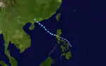
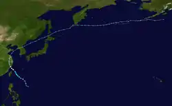
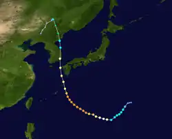
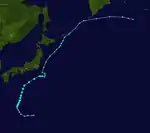
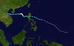
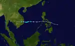
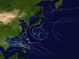 Season summary map | |
| Seasonal boundaries | |
| First system formed | May 8, 2020 |
| Last system dissipated | December 29, 2020 |
| Strongest storm | |
| Name | Goni |
| • Maximum winds | 220 km/h (140 mph) (10-minute sustained) |
| • Lowest pressure | 905 hPa (mbar) |
| Seasonal statistics | |
| Total depressions | 32, 1 unofficial |
| Total storms | 23 |
| Typhoons | 10 |
| Super typhoons | 2 (unofficial)[nb 1] |
| Total fatalities | 457 total |
| Total damage | $4.06 billion (2020 USD) |
| Related articles | |
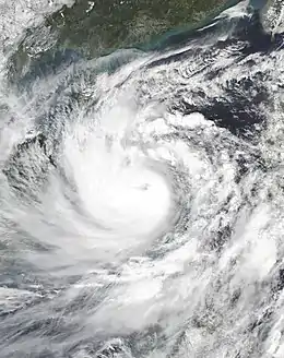
The season's first named storm, Vongfong (Ambo), developed east of Mindanao and rapidly intensified to become a Category 3 typhoon at peak intensity, undergoing an eyewall replacement cycle and made landfall on Samar Island, causing US$50 million damage to the Philippines, while in the midst of the COVID-19 pandemic. In August, Typhoon Hagupit and Severe Tropical Storm Mekkhala struck Eastern China while Typhoons Bavi, Maysak, and Haishen struck the Korean Peninsula in a span of only two weeks, with Haishen becoming the strongest of the season. In October and November, a slew of tropical disturbances and cyclones hit Central Vietnam triggering severe flooding and killing more than 270 people. It then hit Cambodia causing more severe flooding and affecting tens of thousands of homes and over 180,000 hectares of farms. 44 deaths were confirmed in that nation.[1] Later that month, Typhoon Saudel formed, hitting the Philippines. By the end of October, Typhoon Goni became the strongest typhoon of the season surpassing Haishen, and the world's strongest tropical cyclone in 2020. This, however, was later surpassed by Cyclone Yasa.
The scope of this article is limited to the Pacific Ocean to the north of the equator between 100°E and 180th meridian. Within the northwestern Pacific Ocean, there are two separate agencies that assign names to tropical cyclones which can often result in a cyclone having two names. The Japan Meteorological Agency (JMA) will name a tropical cyclone should it be judged to have 10-minute sustained wind speeds of at least 65 km/h (40 mph) anywhere in the basin, whilst the Philippine Atmospheric, Geophysical and Astronomical Services Administration (PAGASA) assigns names to tropical cyclones which move into or form as a tropical depression in their area of responsibility located between 135°E and 115°E and between 5°N–25°N regardless of whether or not a tropical cyclone has already been given a name by the JMA. Tropical depressions that are monitored by the United States' Joint Typhoon Warning Center (JTWC) are given a number with a "W" suffix.
Seasonal forecasts
| TSR forecasts Date | Tropical storms | Total Typhoons | Intense TCs | ACE | Ref. |
|---|---|---|---|---|---|
| Average (1965–2019) | 26 | 16 | 9 | 294 | [2] |
| May 21, 2020 | 26 | 15 | 8 | 258 | [2] |
| July 9, 2020 | 26 | 14 | 7 | 216 | [3] |
| August 6, 2020 | 21 | 13 | 5 | 157 | [4] |
| Other forecasts Date | Forecast Center | Period | Systems | Ref. | |
| January 22, 2020 | PAGASA | January–March | 0–4 tropical cyclones | [5] | |
| January 22, 2020 | PAGASA | April–June | 2–5 tropical cyclones | [5] | |
| June 24, 2020 | PAGASA | July–September | 6–10 tropical cyclones | [6] | |
| June 24, 2020 | PAGASA | October–December | 4–7 tropical cyclones | [6] | |
| 2020 season | Forecast Center | Tropical cyclones | Tropical storms | Typhoons | Ref. |
| Actual activity: | JMA | 32 | 23 | 10 | |
| Actual activity: | JTWC | 26 | 23 | 12 | |
| Actual activity: | PAGASA | 22 | 15 | 7 | |
During the year several national meteorological services and scientific agencies forecast how many tropical cyclones, tropical storms, and typhoons will form during a season and/or how many tropical cyclones will affect a particular country. These agencies include the Tropical Storm Risk (TSR) Consortium of University College London, PAGASA and Taiwan's Central Weather Bureau. The first forecast for the year was released by PAGASA on January 22 predicting the first half of 2020, within its monthly seasonal climate outlook.[5] The PAGASA predicts that only 0–4 tropical cyclones are expected to form or enter the Philippine Area of Responsibility between January and March, while 5–8 tropical cyclones are expected to form between April and June. This was due to the fact that the El Niño–Southern Oscillation was seeing neutral conditions across the Pacific, and could persist until midyear.[5] On May 21, the TSR issued their extended-range forecast for 2020, forecasting tropical activity below the average normal, with 26 tropical storms, 15 typhoons and 8 intense typhoons.[2] These numbers were supported by the current values from the Indian Ocean Dipole, the Accumulated Cyclone Energy index and the sea-surface temperatures in the Niño 3.75 region, leading to a stronger than normal trade windspeed throughout much of the Western Pacific.[2]
On June 24, the PAGASA issued a climate forecast, predicting the number of tropical cyclones for the second half of the season. They predicted that 6–10 tropical cyclones are expected to form between the months of July and September, while 4–7 tropical cyclones are expected to form between the months of October and December.[6] On July 9, TSR issued their forecast for the season, predicting a well-below average season with 26 named storms, 14 typhoons and only 7 intense typhoons.[3] On August 6, TSR issued their third and final forecast for the season, lowering their numbers to 21 named storms, 13 typhoons and 5 intense typhoons.[4] They mentioned that the 2020 season is expected to be one of the "least active typhoon seasons on record", with a predicted ACE index barely half of the normal and a 96% probability of being a below-average season.[4]
Season summary
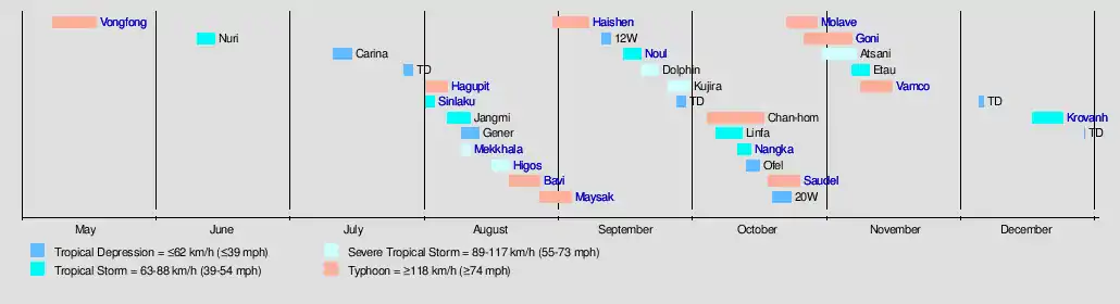
The first few months of 2020 were inactive, with no tropical systems developing until May. On May 8, the season saw its first tropical system with the development of Tropical Depression 01W (Ambo), making it the sixth-latest starting season on record, as well as the latest since 2016. 2 days later, the system strengthened to the first officially named tropical storm of the season, Vongfong. Tropical Storm Vongfong then intensified immediately into a significant typhoon and struck the central part of the Philippines on May 14, first making its landfall in San Policarpo, Eastern Samar, crossing 4 more islands and hit mainland Luzon.
After Vongfong, a month of inactivity ensued, and on June 10, a new tropical depression formed off the coast of Samar, Philippines, and was named Butchoy by the PAGASA a day later. Butchoy made landfall in the Philippines as the JTWC issued a TCFA for it. Once it exited Philippine landmass, Butchoy was upgraded into a tropical depression by the JTWC and all warnings issued by PAGASA was lowered, and Butchoy further intensified into a tropical storm in the West Philippine Sea and was named Nuri by the Japan Meteorological Agency. After Nuri dissipated over mainland China, the basin became quiet again for more than a month with only Tropical Depression Carina forming east of Luzon; this led to the first time that no tropical storms developed within the month of July since reliable records began. The activity in the West Pacific increased somewhat with the formation of Tropical Storm Sinlaku, and the formation and intensification of Hagupit for a typhoon, ending a fast of more than 2 months without any significant typhoon. Hagupit affected China as a mid-Category 1 storm and caused US$441 million in damage. The storm then transitioned to an Extratropical cyclone and affected North Korea and Russia. A few days later, a new tropical depression formed, and then intensified into Tropical Storm Jangmi. Just southwest of Jangmi, a disorganized low-pressure area formed and would soon become Severe Tropical Storm Mekkhala, reaching China. A few days later, a new tropical depression formed in the South China Sea, and the PAGASA named the system as Helen. Shortly after, Helen intensified into a Severe Tropical Storm Higos, the 7th named storm on the 2020 typhoon season. Higos then went on to hit China. Soon after Higos dissipated, a new system formed in the east of the Philippines, and was named Igme. Igme then went on to become Tropical Storm Bavi and rapidly intensify in the coastal waters of Taiwan. In late August, Typhoon Maysak formed along Super Typhoon Haishen, with the systems reached Korean Peninsula and Japan, respectively.
September started with Maysak weakening on its way to Korea, while a new Tropical Storm Haishen formed in the open Pacific, threatening the same areas that Maysak and previously Bavi affected. Typhoon Maysak made landfalls in South Korea and North Korea, while Typhoon Haishen intensified into the first super typhoon of the season. In mid-September, Tropical Storm Noul formed in the South China Sea, made landfall in Vietnam, and dissipated soon after. Later in the month, Tropical Storm Dolphin formed off the east coast of Japan and dissipated after a short life. Near the end of the month, Kujira formed and intensified into a severe tropical storm, before weakening and becoming extratropical.
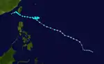
October was very active in the basin. The season started out with Typhoon Chan-hom, which lasted for 14 days before dissipating. On October 9, Tropical Storm Linfa formed, becoming the first of a train of tropical systems to affect Vietnam. Linfa killed more than 100 people and caused severe flooding in Vietnam and Cambodia. Nangka formed a few days after Linfa, though impacts were much less. A tropical depression, dubbed Ofel by the PAGASA went through the Philippines and then hit Vietnam, affecting the already flooded areas. After a short lull in systems, Typhoon Saudel formed on October 18, causing flooding in the Philippines. Afterwords, two very powerful typhoons formed after Saudel: Molave and Goni. The former killed 41 people throughout The Philippines, Vietnam, and Malaysia, while the latter became a Category 5-equivalent super typhoon.[nb 1] After Goni, Atsani formed and lashed Northern Luzon and Southern Taiwan as a tropical storm. As Atsani dissipates, another depression formed and affected Visayas as a depression, giving the name Tonyo. The next day, it was upgraded to a tropical storm, earning the name Etau. Etau lasted from November 7 until November 11. On November 8, a depression formed in the Philippine Area of Responsibility and was given the name Ulysses. The next day, it was upgraded to a tropical storm, giving the name Vamco. Vamco strengthened into an equivalent of a Category 2 typhoon as it brushed the Luzon landmass. It quickly exited the Philippine Area of Responsibility the next day as the PAGASA stated that it restrengthened as a typhoon. It rapidly strengthened and reached its peak intensity as a Category 4 typhoon. It weakened into a Category 1 as it approached Vietnam. It weakened further, finally, dissipated north of Laos. Atlast in the month of December, three systems formed with one named as Krovanh which formed at the South China Sea. Then the season concluded on December 29 with a weak depression close to the coast of Vietnam.
Systems
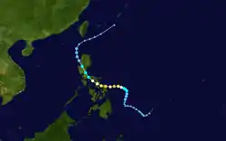
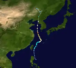
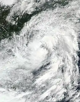
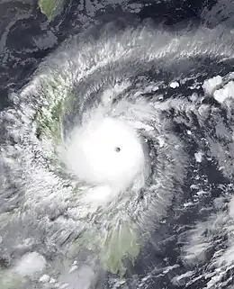
Typhoon Vongfong (Ambo)
| Typhoon (JMA) | |
| Category 3 typhoon (SSHWS) | |
  | |
| Duration | May 8 – May 18 |
|---|---|
| Peak intensity | 155 km/h (100 mph) (10-min) 960 hPa (mbar) |
After 4 consecutive months of inactivity in the Western Pacific basin, a low-pressure area was first noted on May 9 by the JTWC near Micronesia and was given a medium chance of developing into a tropical cyclone.[8] The following day, the JMA declared that it had developed into a tropical depression to the east of Mindanao, Philippines and was expected to slowly move west.[9] The JTWC then issued a Tropical Cyclone Formation Alert (TCFA) for the embryonic system just hours later while convection began to gradually obscure the center.[10] Later that day, the PAGASA followed suit and upgraded the system to a tropical depression, assigning it the name Ambo, as it became the first tropical cyclone to enter their area of responsibility for 2020.[11][12]
The system began to slowly drift westwards throughout the following days,[13] gradually intensifying with occasional convective bursts occurring near the slightly elongated circulation. On the next day, the JTWC upgraded Ambo into a tropical depression, designating it as 01W.[14] The storm gradually intensified throughout the day, as signified by a well-defined rain band developing on the northwestern side, and began to turn north. At this time, the JMA upgraded 01W to a tropical storm and assigned it the first name of the year, Vongfong.[15] Shortly after, the JTWC followed and upgraded the system to tropical storm intensity.[16] Utilizing favorable conditions with low wind shear, 29–30 °C waters, and excellent outflow, Vongfong began to rapidly intensify by early May 13.[17] Shortly after, the JMA upgraded the system to a severe tropical storm. Soon after, the JTWC upgraded the storm to a Category 1 typhoon with 1-minute sustained winds of 130 km/h (80 mph) as the structure quickly improved. The PAGASA and JMA would then upgrade the system to a typhoon later in the day,[17] with the JTWC quickly upgrading the system to a Category 2 typhoon as the eye became clearer. A few hours later, Vongfong intensified to a Category 3-equivalent typhoon.[18] Then, the storm later went an eyewall replacement cycle, quickly finishing the cycle while fluctuating in intensity.[19] At 12:15 pm PST on May 14, Vongfong made its first landfall in San Policarpo, Eastern Samar.[20] Vongfong gradually weakened shortly after, crossing over the Ticao Pass as it moved further inland.[21] By the succeeding day, PAGASA recorded five more landfalls: hitting the islands of Dalupiri Island, Capul Island, Ticao Island, Burias Island, and San Andres, Quezon in Luzon Island's Bondoc Peninsula.[22] Ambo weakened into a Category 1 storm due to these multiple landfalls, although the storm was situated in favorable atmospheric conditions.[23] The system further weakened on May 15, and was downgraded by both the JMA and PAGASA to a severe tropical storm,[24][25] with the JTWC downgrading it to a tropical storm as well. Then, Vongfong made its 7th landfall in Real, Quezon, and began to head further inland into Luzon.[26][27] Vongfong then further weakened and was downgraded by the JMA and the PAGASA into a tropical storm.[28][29] The weakening trend continued, and by May 16, Vongfong emerged into the Luzon Strait as a low-end tropical storm, with the storm's center exposed as the result of the mountainous terrains of the Luzon landmass.[30][19] After emerging, 6 hours later, the JTWC downgraded Vongfong into a tropical depression, and issued their final warning.[31] Soon after, PAGASA followed suit,[32] and the JMA as well.[33] The remnants of the storm fully dissipated by May 17, with PAGASA downgrading the storm's remains into an low-pressure area.[34][19]
In preparation for the incoming typhoon, Tropical Cyclone Wind Signal (TCWS) #3 warnings were issued for Northern Samar and the northern portion of Eastern Samar.[35] According to the NDRRMC, Typhoon Vongfong (Ambo) left ₱1.57 billion (US$31.1 million) worth of damages in agriculture, and left 5 dead, as of May 27.[36][37] With the multi-billion peso damages in the Philippines, the name Ambo was retired by the PAGASA and will be replaced with a new name for the 2024 Pacific typhoon season.
Tropical Storm Nuri (Butchoy)
| Tropical storm (JMA) | |
| Tropical storm (SSHWS) | |
  | |
| Duration | June 10 – June 14 |
|---|---|
| Peak intensity | 75 km/h (45 mph) (10-min) 996 hPa (mbar) |
On June 10, the JMA began monitoring on a weak tropical depression that had developed to the east of the Philippine island of Samar in Visayas.[38] During the next day, the PAGASA began tracking the system, giving the local name Butchoy.[39][40] The storm then made its first landfall in Polillo Island in Quezon at 5:30 pm PHT, and making its second landfall in Infanta, Quezon shortly thereafter.[41] Soon after, the JTWC issued a Tropical Cyclone Formation Alert for the storm.[42] Afterwards, the JTWC officially upgraded Butchoy to a tropical depression, and designated it as 02W.[43] With a favorable environment with low vertical wind shear, moderate equatorial outflow and 30–31 °C sea surface temperatures,[43] Butchoy started to intensify in the West Philippine Sea, becoming a tropical storm and receiving the name Nuri from the JMA later on the same day.[44] Then, PAGASA issued their final warning on Nuri as it exited the Philippine Area of Responsibility.[45] By the next day, Nuri intensified further and subsequently peaked in intensity, with the JMA analyzing the storm's peak winds of 75 km/h (45 mph).[46] Six hours later, the JTWC upgraded Nuri to a tropical storm.[47] However, later in the same day, the JTWC downgraded Nuri into a tropical depression, citing that the storm has drifted into high vertical wind shear.[48] The JMA followed suit, downgrading Nuri into a depression.[49] The JTWC issued their final warning on Nuri as the storm subsequently made landfall in Yanjiang, China.[50][51] The JMA followed suit six hours later, issuing their final warning on the system.[52]
The PAGASA issued Tropical Cyclone Signal No. 1 for western Mindanao, southern Luzon, and Visayas on June 11 as Butchoy neared the Philippines.[53] The combination of the system and prevailing southwesterly winds brought showers and thunderstorms across the Philippines.[54] Heavy rainfall in Albay led to the activation of disaster risk management officials and other emergency assets.[53] The rains from the tropical depression prompted PAGASA to declare the start of the rainy season in the Philippines on June 12, 2020, which was also during the country's Independence Day.[55][56] In Hong Kong, Nuri brought heavy rain. One person also drowned due to rough waters.[57]
Tropical Depression Carina
| Tropical depression (JMA) | |
  | |
| Duration | July 11 – July 15 |
|---|---|
| Peak intensity | <55 km/h (35 mph) (10-min) 1004 hPa (mbar) |
After about one month of inactivity, on July 11, the JMA designated an low-pressure area near Luzon as a tropical depression.[58] The next day, the JTWC designated the depression as an invest and was given a low chance of developing, and later upgraded to a medium chance.[59] On the following day, the PAGASA upgraded the low-pressure system to a tropical depression and named it Carina.[60]
Over an environment favorable for further development, with low vertical wind shear, established equatorial outflow and 28–29 °C sea surface temperatures,[59] Carina generally moved north-northwest until midday (12:00 UTC) on July 14, when Carina rapidly weakened into a low-pressure area, due to unfavorable environment of strong wind shear and diffluent easterly flow.[59][61] PAGASA then issued their final advisory to Carina, and the remnants dissipated on July 15.[62][63]
As the low-pressure system was named Carina, PAGASA immediately hoisted Signal #1, the lowest of their storm warning signals, to Batanes, Babuyan Islands and the northeastern portion of Cagayan.[64] Due to heavy rainfall caused by Carina, the storm caused some minimal damage on Ilocos Norte, Abra and Isabela.[65]
Typhoon Hagupit (Dindo)
| Typhoon (JMA) | |
| Category 1 typhoon (SSHWS) | |
  | |
| Duration | July 30 – August 5 |
|---|---|
| Peak intensity | 130 km/h (80 mph) (10-min) 975 hPa (mbar) |
On July 31, JMA began monitoring a weak tropical depression that developed in the Philippine Sea.[66] Later, PAGASA later named the depression Dindo.[67] By the next day, the Joint Typhoon Warning Center designated Dindo as 03W.[68] With favorable conditions of low vertical wind shear, strong equatorial outflow and 31 °C sea surface temperatures,[68] Dindo intensified into a tropical storm on midday of the same time, and the Japan Meteorological Agency named it as Hagupit.[69] Hagupit then began intensifying in the Philippine Sea, and by August 2, Hagupit was upgraded into a typhoon by the JTWC.[70] The JMA later upgraded Hagupit to a severe tropical storm late on August 2.[71] As Hagupit exited the Philippine Area of Responsibility (PAR), the PAGASA issued its final bulletin on the system.[72] Hagupit was then upgraded into typhoon status by the JMA on August 3,[73] and will later peak in intensity with a pressure of 975 hPa.[74] At around 19:30 UTC, Hagupit made landfall in Wenzhou, China, with winds of 85 mph and pressure of 975 mbar (hPa).[75] After its landfall, Hagupit gradually weakened over China, and by early August 4, the JTWC downgraded the typhoon into a tropical storm.[76] Around midday of the same day, JTWC downgraded Hagupit into a tropical depression and later issued their final advisories on the storm,[77] but the JMA still monitored Hagupit as a tropical storm.[78] The system later would undergo an extratropical transition, a process which got completed on August 6, and the JMA issued their final advisory on the extratropical Hagupit.[79]
In advance of Hagupit, Chinese officials ordered the evacuation of areas vulnerable to flooding.[80] Hagupit caused torrential rainfall over portions of China peaking at 13.11 inches (333 mm) in the Jingshan district of Wenzhou.[81] 15 people were reported dead across South Korea, 6 of them following a landslide in South Chungcheong Province, 11 people were reported missing, and 7 people were injured.[82][83]
Tropical Storm Sinlaku
| Tropical storm (JMA) | |
| Tropical storm (SSHWS) | |
  | |
| Duration | July 31 – August 3 |
|---|---|
| Peak intensity | 75 km/h (45 mph) (10-min) 985 hPa (mbar) |
On July 29, a tropical disturbance formed and was situated a couple hundred miles east of Manila, Philippines.[84] Struggling to consolidate, the disturbance crossed Luzon with little to no organization and began organizing in the South China Sea.[84] Environmental conditions became conducive for development, and the JMA declared that a tropical depression had formed in the early hours of July 31.[85] Then early on August 1, the depression intensified into Tropical Storm Sinlaku.[86] The storm failed to intensify much afterward, and during the following day, Sinlaku made landfall on northern Vietnam.[87] Shortly thereafter, both agencies issued final advisories on the storm.[88][89]
Sinlaku produced heavy rain across central and northern Vietnam, resulting in significant flooding. Two people died, one from a collapsed embankment and the other from flash flooding. Thousands of homes were inundated and crops suffered extensive damage.[90] Damage in the nation was about nearly 5.4 billion đồng (US$232,900).[91] Flash floods across Thailand also killed two people.[92]
The remnants of Sinlaku emerged in the Indian Ocean and intensified into a well marked low pressure area between August 5–8, recreating a lot of torrential rain in portions of India.[93][94]
Tropical Storm Jangmi (Enteng)
| Tropical storm (JMA) | |
| Tropical storm (SSHWS) | |
  | |
| Duration | August 6 – August 11 |
|---|---|
| Peak intensity | 85 km/h (50 mph) (10-min) 994 hPa (mbar) |
On August 6, the Philippine Atmospheric, Geophysical and Astronomical Services Administration started to monitor a low-pressure area that developed well east of Virac, Catanduanes.[95] On the next day, the Japan Meteorological Agency designated the low-pressure area as a weak tropical depression.[96] Despite a broad and elongated low-level circulation center, it gradually organized, prompting the Joint Typhoon Warning Center to issue a Tropical Cyclone Formation Alert on the depression.[97]
Early on next day, the PAGASA upgraded it to a depression, naming it Enteng.[98] Later around the same day, the JTWC designated the depression as 05W.[99] But, near end on the same day, the Japan Meteorological Agency upgraded the depression to a tropical storm, receiving the name Jangmi.[100] As such, Jangmi became the fifth named tropical storm of the 2020 typhoon season.[100] On August 9, Jangmi was upgraded into a tropical storm by the JTWC.[101] Despite being at favorable conditions of low vertical shear and 29–30 °C sea surface temperatures, an upper-level low present to the west of the system prohibited the broad Jangmi to organize further.[101] Around the same time, the PAGASA dropped advisories on Jangmi as it quickly exited the Philippine Area of Responsibility.[102] Moving northward at 23 knots,[101] the JMA reported that Jangmi already peaked at 45 knots (50 mph; 85 km/h).[103] Around 05:50 UTC on August 10, Jangmi made landfall on the southern tip of Geojedo, Gyeongsang Province in South Korea.[104] The JTWC issued their final advisories on Jangmi around 15:00 UTC of the same day,[105] and the JMA issued their final advisory early on the next day, August 11.[106]
Jangmi dropped drenching rainfall through the Ryukyu Islands of Japan, with a peak amount of 2.2 inches (55.8 mm) recorded on the island of Kumejima. In South Korea, Jangmi dropped up to 2.6 inches (66.04 mm) of precipitation, in an area already hard hit by flooding in the months previous to Jangmi.[107][108]
Tropical Depression 06W (Gener)
| Tropical depression (JMA) | |
| Tropical storm (SSHWS) | |
  | |
| Duration | August 9 – August 13 |
|---|---|
| Peak intensity | 55 km/h (35 mph) (10-min) 1012 hPa (mbar) |
A hybrid system formed on August 7, to the south of Japan. It slowly moved westwards, and on August 9, it transitioned into a tropical cyclone.
Due to the fact that the disturbance already had tropical-storm-force winds, it was immediately declared a tropical storm by the JTWC on August 9.[109] The next day, the tropical depression reached its peak intensity of 35 mph with an unusually high pressure of 1012 mbar. Soon afterwards 06W began to gradually weaken, and at 15:00 UTC on August 10, the JTWC downgraded 06W to a tropical depression.[110]
Tropical Depression 06W then ceased to be monitored by the JMA on August 12 due to collapses in the convective activity, dry upper-level air intake, and other factors and ending its official monitoring, yet the JTWC still continued to issue updates normally for 06W even though the system had little signs of activity.
After moving generally westward, the system began to move to the southwest and, at 20:00 UTC (4:00 am, August 13 PST), it entered the Philippine's area of responsibility and was given the name Gener by PAGASA.[111][112] At 03:00 UTC on August 13, the JTWC issued its final warning on 06W, ending the monitoring of agency and global agencies.
Severe Tropical Storm Mekkhala (Ferdie)
| Severe tropical storm (JMA) | |
| Category 1 typhoon (SSHWS) | |
  | |
| Duration | August 9 – August 11 |
|---|---|
| Peak intensity | 95 km/h (60 mph) (10-min) 992 hPa (mbar) |
Another area of persistent convection formed within the proximity of the trough that would also spawn Tropical Storm Jangmi On August 7, west of Luzon. As Jangmi became the dominant system in the area, this low-pressure area remained disorganized. However, on the next day, as Jangmi moved away from the area, the system began to organize, and on August 9, the JTWC upgraded the storm to a Tropical Depression.[113] Soon after, at 8:00 pm. PST, the PAGASA followed and upgraded the storm and gave it the name Ferdie.[114] By the next day, the JTWC upgraded Ferdie into a tropical storm. The PAGASA then issued its last warning as Ferdie exited the Philippine Area of Responsibility. Then soon, the JMA followed suit and upgraded Ferdie to a tropical storm, giving it the international name Mekkhala. At 07:30 CST on August 11 (23:30 UTC on August 10), Mekkhala made landfall at Zhangpu County in Fujian, China shortly after peak intensity.[115]
Mekkhala forced a Signal No. 1 warning to be placed for the Ilocos region in the Philippines. Mekkhala brought monsoonal conditions to portions of Luzon, shortly after its formation.[116] Although remain well offshore Taiwan, the storm still brought heavy rainfall to the island.[117]
In China, local officials suspended ferry services and told ships to return to port, in preparation for Mekkhala.[118] The China Meteorological Administration issued a Level III emergency response, while flood control workers were sent to areas which were hit by Mekkhala.[119] Mekkhala dropped torrential rainfall over China with amounts of up to 7.874 inches (200 mm) reported in some areas. Train services were halted and flights were canceled at local airports as Mekkhala moved onshore.[120] In Zhangzhou, Fujian, damage from the storm reached 1.1 billion yuan (US$159 million).[121]
Severe Tropical Storm Higos (Helen)
| Severe tropical storm (JMA) | |
| Tropical storm (SSHWS) | |
  | |
| Duration | August 16 – August 20 |
|---|---|
| Peak intensity | 100 km/h (65 mph) (10-min) 992 hPa (mbar) |
A new tropical depression formed from the Intertropical Convergence Zone east of Luzon on August 16. At 15:00 UTC, the PAGASA named the system Helen and began issuing severe weather bulletins for the tropical depression, but dropped the alerts as Helen left the Philippine area of responsibility after 4 hours.[122][123] By the next day, Helen intensified into a tropical storm, being given the name Higos by the JMA. Later in the day, the Joint Typhoon Warning Center also upgraded Higos into a tropical storm. JMA eventually upgraded the system to a severe tropical storm by evening that day. The Hong Kong Observatory and Macau Meteorological and Geophysical Bureau upgraded Higos into a marginal typhoon prior to landfall, with sustained hurricane-force winds in Macau indicating such an intensity. Higos made landfall over Zhuhai, Guangdong at peak intensity at around 06:00 CST on August 19 (22:00 UTC on August 18).[124]
In preparation for Higos, the Hong Kong Observatory raised the number 9 tropical cyclone warning signal in Hong Kong to warn of the possibility of hurricane-force winds. Winds generally reached gale to storm force over the southern part of Hong Kong under the influence of Higos' small circulation.[125] The Macao Meteorological and Geophysical Bureau issued the number 10 signal, the highest signal, at 05:00 am local time.[126] Over 65,000 people evacuated and schools were closed across these areas. Although heavily populated areas of China were directly hit by Higos, damage was mostly limited to downed trees and power outages.[127] Two campers who were unaware of the approaching storm had to be rescued from Tap Mun Island after arriving on August 14.[128] The storm also left 7 deaths and 45 billion đồng (US$2 million) in damages in Vietnam.[129]
Typhoon Bavi (Igme)
| Typhoon (JMA) | |
| Category 3 typhoon (SSHWS) | |
  | |
| Duration | August 20 – August 27 |
|---|---|
| Peak intensity | 155 km/h (100 mph) (10-min) 950 hPa (mbar) |
On August 19, the JTWC began monitoring a broad area of low pressure situated a couple hundred miles northeast of the Philippine archipelago. By the next day, the system rapidly organized, and the JTWC subsequently issued a Tropical Cyclone Formation Alert (TCFA). On August 21, the area of low pressure became Tropical Depression 09W.[130] At 15:00 UTC, the PAGASA named the system Igme and issued a severe weather bulletin for it.[131] By the next day, Igme intensified into a tropical storm, according to the JMA and was given the name Bavi,[132] subsequently prompting the JTWC to follow suit and upgrade 09W from a tropical depression to a tropical storm. Favorable conditions allowed Bavi to rapidly intensify, and by 12:00 UTC on August 22, the system became a severe tropical storm. As the system left the Philippine Area of Responsibility, the PAGASA stopped issuing weather bulletins for the severe tropical storm.[133] Bavi's period of rapid intensification was brief, and it began a slow intensification phase on August 23.
On August 24, Bavi slowly intensified, and it was later upgraded by the JMA into a typhoon. Later on that day, it became a Category 2 typhoon. By the next day, Bavi intensified even more to become a major Category 3 typhoon. As Bavi moved closer to the Korean peninsula, one person died in Jeju island on August 25.[134] At around 00:30 UTC on August 27, Bavi made landfall over North Pyongan Province, North Korea.[135] After that, Typhoon Bavi transitioned into an extratropical storm in Manchuria, China.
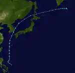
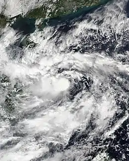
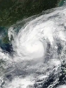
Typhoon Maysak (Julian)
| Typhoon (JMA) | |
| Category 4 typhoon (SSHWS) | |
  | |
| Duration | August 27 – September 3 |
|---|---|
| Peak intensity | 175 km/h (110 mph) (10-min) 935 hPa (mbar) |
A low-pressure area east of the Philippines consolidated into a tropical depression on August 27, and simultaneously, a Tropical Cyclone Formation Alert was issued for the system.[136][137] Early on August 28, PAGASA upgraded it to a tropical depression with the local name Julian,[138] shortly before the JMA upgraded it to a tropical storm and assigned the international name Maysak.[139] Subsequently, the JTWC upgraded Maysak to a tropical storm too,[140] and then the JMA upgraded it to a severe tropical storm despite its elongated low-level circulation center.[141][142] At 19:00 UTC August 29, the system was upgraded to a typhoon by the JMA and two hours later, PAGASA followed and also upgraded the system to typhoon status.[143] Later on that day, it became a Category 2 typhoon. By the next day, Maysak intensified even more to become a major Category 3 typhoon. Then later on afternoon, it was upgraded to a Category 4 typhoon. Soon, Maysak began to weaken bit-by-bit as it passed the East China Sea, slowing back down to a Category 3 storm.[144]
Typhoon Maysak then made landfall near Busan, South Korea at 02:20 KST on September 3 (17:20 UTC on September 2), with 10-minute maximum sustained winds at 155 km/h (100 mph) and the central pressure at 950 hPa (28.05 inHg).[145] equivalent to a Category 2 typhoon. After that, it crossed the Sea of Japan and hitting North Korea into Jilin, Manchuria in China. Soon after, Typhoon Maysak degenerated into an extratropical low in northeast China.[146]
On September 2, the Panamanian-registered animal transport ship Gulf Livestock 1 transmitted a Mayday and launched lifeboats, at least one of which was found. The ship was west of Japan's Amami Ōshima Island. The Japan Coast Guard has said that the freighter was carrying a crew including 39 Filipinos, 2 Australians, and 2 New Zealanders when it disappeared. The cargo was 5,867 cattle, loaded in Napier, New Zealand, and bound for the port of Jingtang in Tangshan, China.[147] Two fatalities occurred in South Korea where also 120,000 households lost power.[148] In North Korea, Maysak dropped 15.157 inches (385 mm) of precipitation in Wonsan.[149]
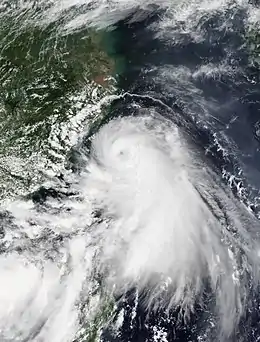
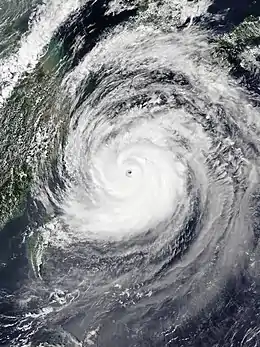
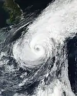
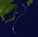
Typhoon Haishen (Kristine)
| Typhoon (JMA) | |
| Category 4 super typhoon (SSHWS) | |
  | |
| Duration | August 30 – September 7 |
|---|---|
| Peak intensity | 195 km/h (120 mph) (10-min) 910 hPa (mbar) |
On August 29, the JTWC began tracking a very disorganized tropical disturbance situated a couple hundred miles northeast of Guam, noting that no major models but the European Center for Medium-range Weather Forecasting's ECMWF model had forecasted for any significant development. By the next day, the disturbance had quickly organized, and the JTWC issued a Tropical Cyclone Formation Alert (TCFA) for the low-pressure area,[150] and by the next day, it intensified into Tropical Depression 11W.[151] Traversing generally southwestward, the depression quickly intensified into a tropical storm.[152] The JMA soon followed and upgraded the system into a tropical storm as well, and gave the storm the international name Haishen. Later that day, Haishen became a severe tropical storm as it headed southwest into the Philippine Sea. Intensification on September 3 was significant, with Typhoon Haishen acquiring a pinhole eye early in the day, but underwent a merger eyewall replacement cycle/MERC due to the eyewall being inertially unstable. This allowed the eyewall to be more robust and stable, and continual rapid intensification continued throughout the day.
Upon entering the Philippine Area of Responsibility (PAR), the Philippine Atmospheric, Geological and Atmospheric Services Administration (PAGASA) named the system Kristine.[153][154] Early on September 4, the JTWC assessed that Haishen became a Category 4-equivalent super typhoon – with 1-minute sustained wind speeds of 135 kt (155 mph; 250 km/h),[155] with a clear, symmetrical eye visible on satellite imagery.[156] On September 5, as Haishen's latitude increased, the ocean heat content in the area decreased,[157] which disrupted the system's core and caused its eye to appear ragged on satellite imagery, subsequently indicating weakening, and dropping below super typhoon status.[158] Later that day, the system left the PAR and PAGASA issued its last bulletin on the typhoon.[159]
As the system continued its northward track toward the Japanese archipelago, it continued to weaken and became a category 3 typhoon, and not too long after it dropped to a category 2 typhoon as it neared the Southern Ryukyu Islands of Japan. A mandatory evacuation order was issued for western Japan as millions of people evacuated accordingly.[160] Haishen made landfall in Ulsan, South Korea at around 09:00 KST (00:00 UTC) on September 7,[161] with 10-minute maximum sustained winds at 140 km/h (85 mph) and the central pressure at 955 hPa (28.20 inHg).
Haishen caused two fatalities in Japan, while four others went missing after a mudslide occurred in Miyazaki Prefecture.[162] Two more fatalities occurred in South Korea and widespread flooding occurred in neighboring North Korea.[163]
Tropical Depression 12W
| Tropical depression (JMA) | |
| Tropical depression (SSHWS) | |
  | |
| Duration | September 10 – September 12 |
|---|---|
| Peak intensity | 55 km/h (35 mph) (10-min) 1006 hPa (mbar) |
On September 10, the JMA began tracking a tropical disturbance to the north-northwest of Iwo-To, Japan. At 15:00 UTC that day, the JTWC issued a Tropical Cyclone Formation Alert on the system.[164] By 03:00 UTC on September 12, the JTWC declared the system as a Tropical Depression 12W.[165] However, the JTWC issued its final warning on the system later that day.[166]
Tropical Storm Noul (Leon)
| Tropical storm (JMA) | |
| Tropical storm (SSHWS) | |
  | |
| Duration | September 15 – September 19 |
|---|---|
| Peak intensity | 85 km/h (50 mph) (10-min) 992 hPa (mbar) |
On the morning of September 15, the JTWC issued a tropical cyclone formation alert for a tropical system forming in the Philippine Sea.[167] Later that day, the JMA upgraded the system to a tropical depression and assigned it the international name Noul. The JTWC later followed at 15:00 UTC as they issued their first warning on the system as Tropical Depression 13W.[168] Since the depression formed inside of the Philippine Area of Responsibility (PAR), the PAGASA immediately issued a severe weather bulletin on the storm and named the system Leon.[169] At 21:00 on September 16, the storm left the PAR and PAGASA issued its final warning on the system.[170] At 03:00 UTC September 18, Noul made landfall between Quảng Trị and Thừa Thiên-Huế provinces. At 09:00 UTC, the JTWC issued its final warning on the system.[171] After being downgraded to a low pressure area (LPA), Noul followed a westward path and emerged in the Indian Ocean.
A few days before the storm hit Vietnam, the Vietnamese government closed three airports and evacuated more than one million people in the affected areas.[172][173][174] Noul damaged homes and knocked down trees and power lines in Hue, Vietnam.[175] Heavy precipitation amounts peaking at 310 mm (12.20 inches) fell in Da Nang.[176] The storm caused 6 deaths and 705 billion đồng (US$30.4 million) in damage.[177][178][179]
The remnants of Noul left the western Pacific after the landfall and reached the waters of the northern Indian Ocean. The remnants created several areas of convection and caused heavy rains, landslides, floods, causing some damages in Bangladesh, northeast of India and Myanmar. No death was reported.
Severe Tropical Storm Dolphin (Marce)
| Severe tropical storm (JMA) | |
| Tropical storm (SSHWS) | |
  | |
| Duration | September 19 – September 24 |
|---|---|
| Peak intensity | 110 km/h (70 mph) (10-min) 975 hPa (mbar) |
On September 20 at 06:00 UTC, as a tropical disturbance strengthened in the extreme northeast corner of the Philippine Area of Responsibility, PAGASA upgraded the system to a tropical depression, giving it the local name Marce.[180] At the time, the JTWC only recognized the system as an area of convection and only issued a medium level of warning for the system.[181] The JTWC upgraded the system to a tropical storm at 12:00 UTC.[182] On September 21 at 03:00 UTC, the system left the Philippine Area of Responsibility.[183] The system then intensified into a tropical storm on the southern seas of Japan, earning the international name Dolphin from the JMA.[184] After the storm transitioned into an extratropical cyclone, the JTWC issued its final warning on the system on September 24 at 03:00 UTC.[185]
Severe Tropical Storm Kujira
| Severe tropical storm (JMA) | |
| Category 1 typhoon (SSHWS) | |
  | |
| Duration | September 25 – September 30 |
|---|---|
| Peak intensity | 110 km/h (70 mph) (10-min) 980 hPa (mbar) |
On September 25, The JTWC first noted the possibility of tropical cyclone formation from an area of convection northeast of the Northern Mariana Islands. Over the next few days, the system organized and on September 27, both the JMA and the JTWC upgraded the system to a tropical storm, with the JMA assigning the name Kujira. The storm drifted north-northwestwards before recurving to the northeast while intensifying into a Category 1-equivalent typhoon early on September 29.[186] Kujira weakened to a tropical storm 12 hours after it intensified into a typhoon due to very high wind shear and cool waters. At 21:00 UTC, the JTWC issued the last advisory for the system.[187]
Typhoon Chan-hom
| Typhoon (JMA) | |
| Category 1 typhoon (SSHWS) | |
  | |
| Duration | October 4 – October 17 |
|---|---|
| Peak intensity | 130 km/h (80 mph) (10-min) 965 hPa (mbar) |
On October 2, the JTWC began to monitor a large area of thunderstorms in the open Pacific.[188] The system gradually organized, and it was classified as a tropical depression on October 4.[189] On the next day, the JMA upgraded the storm to a tropical storm and named it Chan-hom.[190] On October 7, the system was upgraded by the JMA into a typhoon.[191] The JMA issued their final warning on the system on October 12 at 00:45 UTC.[192] The JTWC later followed, issuing their final warning on the system at 09:00 UTC.[193] The JMA, however, still tracked Chan-hom as a tropical depression until it was last noted on October 16.[194]
Tropical Storm Linfa
| Tropical storm (JMA) | |
| Tropical storm (SSHWS) | |
  | |
| Duration | October 6 – October 12 |
|---|---|
| Peak intensity | 85 km/h (50 mph) (10-min) 994 hPa (mbar) |
On October 9, the JTWC began tracking a tropical system east-southeast of Da Nang, Vietnam.[195] On October 10, the system was declared as a tropical depression by the JTWC and the JMA.[196][197] Later that day, the JMA upgraded the system into a tropical storm and named it Linfa.[198] The system continued westward, making landfall on October 11 at 03:00 UTC in Vietnam.[199] The JTWC issued their final warning on the system at 09:00 UTC that day.[200] The JMA later followed, issuing their final warning on the system at 18:00 UTC.[201]
Linfa brought historic amounts of rainfall to Central Vietnam, peaking at 90.16 inches (2,290 mm) in A Lưới (Huế),[202] 59.842 inches (1,520 mm) in Hướng Linh (Quảng Trị).[203] That made it the 12th wettest tropical cyclone in history.[204] At least 370,000 people in Vietnam lost power after the storm.[205] So far the storm and its flood have left 104 people dead and 38 remain missing in Vietnam and Cambodia.[206][207][208] In Cambodia, severe flooding affected 16 provinces including Phnom Penh, killed at least 21 people, damaged over 25,000 homes over and over 180,000 hectares of farmland.[209]
Tropical Storm Nangka (Nika)
| Tropical storm (JMA) | |
| Tropical storm (SSHWS) | |
  | |
| Duration | October 11 – October 14 |
|---|---|
| Peak intensity | 85 km/h (50 mph) (10-min) 990 hPa (mbar) |
On October 11, the JMA began tracking a tropical depression off the west coast of Luzon.[210] The PAGASA declared the system as a tropical depression at 12:00 UTC, and since the storm formed inside of the Philippine Area of Responsibility (PAR) the agency named the system Nika.[211] On the same day at 21:00, the JTWC began issuing warnings on the system.[212] On October 12, the system was declared a tropical storm by the JMA, and was named Nangka.[213] At 09:00 UTC, the system left the PAR and the PAGASA issued its final bulletin on the system.[214] At 19:20 CST (11:20 UTC) on October 13, Nangka made landfall over Qionghai, Hainan.[215]
On October 13, the storm crossed the Gulf of Tonkin and made landfall in the Nam Định, Ninh Bình, and Thanh Hóa provinces in Northern Vietnam on October 14.[216] On the same day, both the JMA and JTWC issued their final warnings for the system.[217] The system dissipated on October 14, 2020.[218]
After the passage of Nangka over Hainan Island, 2 people died and 4 are missing as a result of a capsized boat.[219] In Northern Vietnam, the storm killed 2 people in Hòa Bình, another missing in Yên Bái.[220] Over 585 houses were destroyed, while 135,731 others across central Vietnam were flooded.[221]
Tropical Depression Ofel
| Tropical depression (JMA) | |
  | |
| Duration | October 13 – October 16 |
|---|---|
| Peak intensity | <55 km/h (35 mph) (10-min) 1002 hPa (mbar) |
A low pressure area formed in the Philippine Sea, east of Leyte, on October 13. Soon, the PAGASA declared the newly formed system as a tropical depression and assigned it the name Ofel. The PAGASA immediately raised warning signals for the province of Sorsogon and for parts of the Samar province.[222] On the same day at 18:30 UTC, Ofel made landfall over Can-avid, Eastern Samar.[223] As the system entered the West Philippine Sea in the early hours of October 15 UTC, the PAGASA lifted all tropical cyclone warning signals for Ofel.[224] On the same day at 20:00 UTC, Ofel left the Philippine Area of Responsibility (PAR) and PAGASA issued their final bulletin for the system.[225] While Ofel was inside the PAR, the Joint Typhoon Warning Center issued tropical cyclone formation alerts for the system,[226] however it was canceled as the system entered a less favorable environment on October 16.[227] The storm dissipated at 03:00 UTC on that day.[228]
Flooding was reported due to moderate to heavy rains. According to the Department of Agriculture Regional Office 5, total damages have topped to an estimated ₱9.1 million (US$187,000).[229]
Typhoon Saudel (Pepito)
| Typhoon (JMA) | |
| Category 1 typhoon (SSHWS) | |
  | |
| Duration | October 18 – October 25 |
|---|---|
| Peak intensity | 120 km/h (75 mph) (10-min) 975 hPa (mbar) |
On October 16 UTC, the JTWC began tracking an area of convection approximately 463 nautical miles (857 km) east-southeast of Palau.[230] On October 18 at 21:00 UTC, the PAGASA upgraded the system into a tropical depression, and named the system Pepito.[231] A few hours later, the JMA also recognized the system into a tropical depression,[232] and subsequently issued their first warning on the system.[233] As the system intensified as it approached Northern Luzon, the JMA upgraded the system into a tropical storm and named the system Saudel.[234] The PAGASA also declared the system as a tropical storm, and began issuing Signal #2 tropical cyclone warnings in preparation for its landfall.[235] Saudel made landfall over the San Ildefonso Peninsula in Casiguran, Aurora on October 20 at 13:00 UTC (21:00 PHT) and began crossing the Luzon Island, emerging over the West Philippine Sea hours later.[236][237] As the storm left the Philippine Area of Responsibility, the developing severe tropical storm was upgraded into a typhoon by the JMA, the JTWC, and by the PAGASA in their final bulletin for the system.[238][239][240]
As of October 24, the NDRRMC reported total damages of about ₱105.8 million (US$2.18 million).[241]
Tropical Depression 20W
| Tropical depression (JMA) | |
| Tropical depression (SSHWS) | |
  | |
| Duration | October 19 – October 23 |
|---|---|
| Peak intensity | 55 km/h (35 mph) (10-min) 1006 hPa (mbar) |
On October 19, the JTWC began tracking a tropical disturbance 160 nautical miles (300 km) west of Iwo To.[242] This disturbance strengthened while tracking north, and was eventually upgraded into a tropical depression by the JTWC.[243][244] The system continued to follow a slightly erratic track in the Pacific Ocean at the south of Japan until it entered an unfavorable environment for development due to strong vertical wind shear, which caused the system to quickly weaken until it dissipated on October 23.[245][246]
Typhoon Molave (Quinta)
| Typhoon (JMA) | |
| Category 3 typhoon (SSHWS) | |
  | |
| Duration | October 22 – October 29 |
|---|---|
| Peak intensity | 165 km/h (105 mph) (10-min) 940 hPa (mbar) |
On October 23, the JMA began tracking a tropical depression approximately 190 nautical miles (350 km) north of Palau.[247][248] On the same day, PAGASA followed suit as the system formed inside of the Philippine Area of Responsibility (PAR), east of Mindanao, and named the system Quinta.[249] On October 24, the JTWC also recognized the system as a tropical depression.[250] At 15:00 of the same day, the JTWC upgraded the system into a tropical storm, with the JMA and PAGASA doing the same a few hours apart from each other. Now a tropical storm, the system was named Molave by the JMA.[251][252][253] On October 25, PAGASA upgraded the system into a severe tropical storm as it tracked closer to the Bicol Region.[254] Later that day, the PAGASA then upgraded Molave into a typhoon as it headed for Albay and Camarines Sur, prompting the raising of Signal #3 tropical cyclone warnings for both and adjacent provinces.[255] Moments later, the JMA also upgraded the system to a typhoon and the JTWC followed a few hours later.[256][257] At 18:10 PHT (10:10 UTC), Molave made its first landfall on the San Miguel Island in Albay, with another in Malinao just 40 minutes later.[258] Molave made a total of 5 landfalls in the Luzon area before entering the West Philippine Sea on October 26.[259][260] On October 27 at 00:00 UTC, Molave left the PAR, with PAGASA issuing their last bulletin for the system later at 15:00.[261][262] After that, Typhoon Molave intensified even more and peaked as a Category 3 major typhoon in the South China Sea. After that, colder sea surface temperatures caused the storm to weaken a bit, and by the next day Molave made landfall in Vietnam as a weakening Category 2 storm.
As of November 9, 2020, the NDRRMC reported that 27 people were killed, 40 people were injured and four went missing after the typhoon.[263] Damage from infrastructure and agriculture counted to be ₱1.56 billion (US$32.2 million) and ₱2.66 billion (US$54.9 million) respectively, with a total damage of ₱4.22 billion (US$87.1 million) nationwide.[263] In Vietnam, Molave left 41 dead, 143 were injured and 42 people missing. Economic losses were estimated to be 12.92 trillion dong (US$558 million).
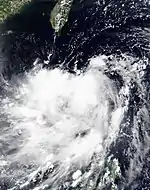
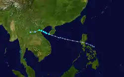
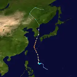
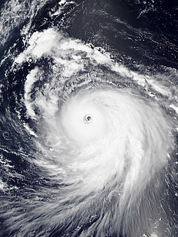
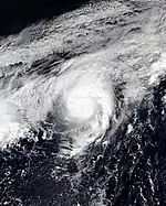
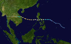
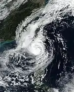
Typhoon Goni (Rolly)
| Typhoon (JMA) | |
| Category 5 super typhoon (SSHWS) | |
  | |
| Duration | October 26 – November 6 |
|---|---|
| Peak intensity | 220 km/h (140 mph) (10-min) 905 hPa (mbar) |
After Typhoon Molave devastated the Philippines, the JMA announced the formation of a new tropical depression in the Pacific Ocean, west of the Mariana Islands, on October 27.[264] By the next day, the JTWC had also followed and upgraded the system into a tropical depression.[265] As the system continued tracking westward under favorable conditions in the Pacific Ocean, the JMA and JTWC upgraded the system into a tropical storm, with the JMA assigning the name Goni to the intensifying storm.[266][267][268] Due to the warm waters surrounding the storm, the system underwent rapid intensification and became a typhoon.[269][270] On October 29, at 9:30 UTC, Goni entered the Philippine Area of Responsibility (PAR) and was named Rolly by the PAGASA.[271] By 18:00 UTC, Goni had intensified into a Category 4-equivalent typhoon, with 1-minute sustained winds at 120 knots (220 km/h; 140 mph), and eventually the first Category 5-equivalent typhoon of the season a few hours later.[272][273] Warm sea surface temperatures, low vertical wind shear and high ocean heat content continually supported Goni as it edged closer to the Philippines, and it maintained its intensity into the next day.[274] At 18:00 UTC October 31 (2:00 PST November 1), PAGASA upgraded Goni to a super typhoon on the agency's tropical cyclone intensity scale[275] at which time the JMA and PAGASA both reported 10-minute sustained winds of 220 km/h (140 mph)[276] and 225 km/h (140 mph), respectively, marking the second time Tropical Cyclone Wind Signal #5 was raised by PAGASA[277] since Typhoon Haima in 2016. Goni made its first two landfalls at peak intensity over Bato, Catanduanes (20:50 UTC)[277] and Tiwi, Albay (23:20 UTC).[278] After that, it weakened into a strong typhoon and made a third landfall in San Narciso, Quezon. Due to three landfalls, Goni lost its immense strength and weakened into a minimal typhoon as it made a fourth landfall in San Juan, Batangas. Before exiting the PAR, Goni slightly intensified, but further development was hampered by unfavorable conditions.[279][280] The capital, Manila, experienced some tropical storm-force winds from Goni.
As of November 11, 2020, the NDRRMC has reported ₱12.9 billion (US$266 million) of infrastructure damages, along with ₱5 billion (US$103 million) of agricultural damage, with a combined total of ₱17.9 billion (US$369 million), and at least 25 deaths, 399 injured and 6 missing.[281] Goni is estimated to have caused at least ₱48.058 billion (US$1.04 billion) in damages in the Philippines.[282]
Severe Tropical Storm Atsani (Siony)
| Severe tropical storm (JMA) | |
| Tropical storm (SSHWS) | |
  | |
| Duration | October 30 – November 7 |
|---|---|
| Peak intensity | 95 km/h (60 mph) (10-min) 992 hPa (mbar) |
On October 28, the JTWC began tracking a new tropical disturbance 95 nautical miles (110 mi) south-southwest of Chuuk in the Federated States of Micronesia.[283] This disturbance would eventually strengthen into a new tropical depression in the early hours of October 29.[284] Later that day, the JMA upgraded the system into a tropical storm.[285] On November 1, at 00:00 UTC, Atsani entered the PAGASA's Philippine Area of Responsibility (PAR), with the PAGASA naming the system Siony.[286][287] The storm tracked northwest through the Philippine Sea, passing through the Luzon Strait on November 4.[288] The system left the PAR on November 7 at 21:00 UTC.[289] Shortly afterwards, the system rapidly weakened and dissipated thereafter.
Atsani downed trees, caused landslides, and damaged street lights in parts of Taiwan. Rockfalls caused some roads to close in Taitung County. 3 minor injuries were reported within Taitung County in the townships of Haiduan and Jinfeng.[290] The storm brought heavy rains to Batanes and the Babuyan Islands in the Philippines,[288] causing ₱4.9 million (US$101 thousand) in agricultural damage.[291]
Tropical Storm Etau (Tonyo)
| Tropical storm (JMA) | |
| Tropical storm (SSHWS) | |
  | |
| Duration | November 6 – November 10 |
|---|---|
| Peak intensity | 85 km/h (50 mph) (10-min) 992 hPa (mbar) |
On November 7, the Japan Meteorological Agency (JMA) began tracking a tropical depression 460 nautical miles (850 km; 530 mi) east-southeast of Manila.[292][293][294] At 12:00 UTC on the same day, the PAGASA declared the system as a tropical depression and assigned it the name Tonyo, as it formed directly over Burias Island.[295] The Joint Typhoon Warning Center recognized the system as a tropical depression at 15:00 UTC on November 8.[296] Etau caused rains over Calabarzon, Mimaropa, and the Bicol Region before exiting the Philippine Area of Responsibility on November 9 at 21:00 UTC.[297] It continued its way towards Vietnam, after crossing Philippines.
Etau killed two people in Quảng Nam and Bình Định and damaged 400 houses when it made landfall in central Vietnam on November 10.[298] The storm produced over 250 mm (10 in) of rain in the provinces of Bình Định, Khánh Hòa, and Phú Yên,[299] with peak at 858 mm in Lake Thủy Yên (Thừa Thiên Huế).[300] The storm also caused gusty winds which uprooted trees and ripped roofs of buildings, many of which were still recovering from the adverse impacts of Typhoon Molave and the weakened Tropical Storm Goni. In addition, power outages locally affected the city of Tuy Hòa.[301] Economic losses in Tuy An, Phú Yên were counted as 122 billion VND (US$5.26 million).[302]
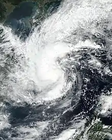
Typhoon Vamco (Ulysses)
| Typhoon (JMA) | |
| Category 4 typhoon (SSHWS) | |
  | |
| Duration | November 8 – November 15 |
|---|---|
| Peak intensity | 155 km/h (100 mph) (10-min) 950 hPa (mbar) |
On November 8, the JMA began tracking a new tropical depression 132 nautical miles (245 km; 150 mi) north-northwest of Palau.[303][304] At 12:00 UTC on the same day, the PAGASA declared the system as a tropical depression inside of the Philippine Area of Responsibility and named it Ulysses.[305] The next day at 7:15 UTC, the system strengthened into a tropical storm, with the JMA giving it the name Vamco,[306] with the Joint Typhoon Warning Center later issuing their first warning on the system as a tropical depression. As the system tracked closer to southern Luzon, both the PAGASA and the JMA upgraded Vamco into a severe tropical storm.[307] Vamco was then upgraded into typhoon status by the JMA on November 11, followed by the JTWC and the PAGASA shortly after, as the PAGASA raised Signal #3 tropical cyclone wind signals in preparation for the storm.[308][309] At 14:30 UTC and 15:20 UTC, Vamco made its first two landfalls over the island towns of Patnanungan and Burdeos, respectively, both in Quezon Province.[310][311] Later at 17:40 UTC, Vamco made its third landfall over General Nakar, Quezon, in the Luzon landmass.[311] At 00:00 UTC, the system emerged over the western seaboard of Zambales and entered the West Philippine Sea.[312] The system left the PAR at 01:30 UTC as the PAGASA redeclared the system as a typhoon.[313] Vamco rapidly re-strengthened in the South China Sea and peaked as a Category 4-equivalent typhoon briefly before weakening back into a Category 3-equivalent storm heading for Vietnam.[314] The typhoon then weakened before making another landfall as a Category 1-equivalent typhoon in Vietnam.[315]
As of 08:00 PHT on December 10, 2020, the NDRRMC reported a total of 196 casualties (Iincluding 101 validated deaths, 85 injuries and 10 missing) caused by the typhoon, along with ₱7.32 billion (US$152 million) worth of agriculture damages and ₱12.9 billion (US$269 million) worth of infrastructural damages. The Cagayan Valley experienced the highest total amount of damage. At least 3,052,049 individuals were affected by the typhoon's onslaught.[316] The Armed Forces of the Philippines and Philippine National Police reportedly rescued 265,339 and 104,850 individuals, respectively.[317][318] According to Aon, total economic losses caused by the typhoon were estimated to top ₱50 billion (US$1 billion).[282]
Tropical Storm Krovanh (Vicky)
| Tropical storm (JMA) | |
| Tropical depression (SSHWS) | |
  | |
| Duration | December 17 – December 24 |
|---|---|
| Peak intensity | 65 km/h (40 mph) (10-min) 1000 hPa (mbar) |
On December 17 at 21:00 UTC, the PAGASA began issuing bulletins for a system 140 nautical miles (260 km) east-southeast of Davao.[319][320] The PAGASA had already recognized the system as a tropical depression and named it Vicky, however at the time, the Japan Meteorological Agency (JMA) only recognized the system as a low-pressure area.[321] The next day, the JMA followed suit and recognized the system as a tropical depression.[322] At 14:00 PHT (6:00 UTC), the system made landfall in Baganga, Davao Oriental.[323] 9 hours later, it emerged off the coast of Misamis Oriental and entered the Bohol Sea, later entering the Sulu Sea on the next day at 5:00 PHT (23:00 UTC).[324] On December 19 at 23:00 PHT (15:00 UTC), Krovanh made its second landfall over central Palawan, emerging into the West Philippine Sea shortly after.[325][326] As the storm traversed the South China Sea, the system had strengthed into a tropical storm according to the JMA as it emerged into a region of relatively favorable atmospheric conditions, thus given the name Krovanh.[327] On December 20 at 14:00 PHT (6:00 UTC), Krovanh left the Philippine Area of Responsibility, although storm signals were still raised for the Kalayaan Islands.[328] The PAGASA then upgraded Krovanh into a tropical storm, and issued a Signal No. 2 warning for the Kalayaan Islands.[329] The next day, December 21, Krovanh was downgraded into a tropical depression by both the JMA and by the PAGASA in their final advisories for the storm.[330][331] The JTWC then issued their final warning on Krovanh the next day shortly after most of its central convection had dissipated due to increasingly hostile wind shear.[332]
Large swaths of Visayas and Mindanao were placed under Signal No. 1 warnings due to Krovanh.[333] Floods and landslides were triggered in Cebu, Agusan del Sur, Davao de Oro, and in Leyte, where two senior citizens were killed in a landslide. In Lapu-Lapu City, 300 residents were forced to evacuate after 76 houses near the shore were swept into sea.[334] Around 6,702 individuals were affected by the storm in the Philippines, with 5,646 in evacuation centers. Damages have been estimated to total up to ₱213.2 million (US$4.48 million). At least eight people were killed by the effects of Krovanh.[335]
Other systems

Late on July 27, the JMA began to track a weak tropical depression in the open Western Pacific.[336] Later on the following day, the system was unofficially classified as a subtropical depression by the JTWC, when it has been given a low-chance of transitioning to a tropical cyclone.[337] On a marginal environment with cyclonic easterly flow, moderate to strong wind shear and 28–30 °C sea surface temperatures, the system was expected to recurve poleward and be absorbed by a larger extratropical low. The depression, however, dissipated on July 30.[338]
The JMA began monitoring on another tropical depression to the south of Japan on September 27.[339] The system moved in a general northeastward direction until it was last noted on 18:00 UTC on September 29.[340]
On October 7, the Vietnam Center for Hydro-Meteorological Forecasting (VNCHF) monitored a tropical depression that had made landfall in the Khánh Hòa province.[341] Enhanced by the seasonal northeast monsoon, the system caused many provinces nearby to experience heavy rainfall with average accumulations of 200–300 mm. In Sa Huỳnh (Quảng Ngãi), rainfalls peaked at 360 mm. By October 11, heavy floods killed 9 people.[342]
On December 5, a tropical depression formed to the south of Japan.[343] The depression was short-lived, however, as it dissipated the next day after being embedded into a frontal zone.[344]
On December 29, the JMA started to track a weak tropical depression to the east of Vietnam.[345]
Storm names
Within the Northwest Pacific Ocean, both the Japan Meteorological Agency (JMA) and the Philippine Atmospheric, Geophysical and Astronomical Services Administration (PAGASA) assign names to tropical cyclones that develop in the Western Pacific, which can result in a tropical cyclone having two names.[346] The Japan Meteorological Agency's RSMC Tokyo – Typhoon Center assigns international names to tropical cyclones on behalf of the World Meteorological Organization's Typhoon Committee, should they be judged to have 10-minute sustained windspeeds of 65 km/h (40 mph).[347] PAGASA assigns names to tropical cyclones which move into or form as a tropical depression in their area of responsibility located between 135°E and 115°E and between 5°N and 25°N even if the cyclone has had an international name assigned to it.[346] The names of significant tropical cyclones are retired, by both PAGASA and the Typhoon Committee.[347] Should the list of names for the Philippine region be exhausted then names will be taken from an auxiliary list of which the first ten are published each season. Unused names are marked in gray.
International names
During the season, 23 tropical storms developed in the Western Pacific and each one was named by the JMA, when the system was judged to have 10-minute sustained windspeeds of 65 km/h (40 mph). The JMA selected the names from a list of 140 names, that had been developed by the 14 members nations and territories of the ESCAP/WMO Typhoon Committee. Retired names, if any, will be announced by the WMO in 2021, though replacement names will be announced in 2022. During the season, the name Saudel was used for the first time after it replaced Soudelor in the 2015 season.
| Name list | |||||||||||
|---|---|---|---|---|---|---|---|---|---|---|---|
| Vongfong | Nuri | Sinlaku | Hagupit | Jangmi | Mekkhala | Higos | Bavi | Maysak | Haishen | Noul | Dolphin |
| Kujira | Chan-hom | Linfa | Nangka | Saudel | Molave | Goni | Atsani | Etau | Vamco | Krovanh | |
Retirement
After the season, the Typhoon Committee announced that the names Vongfong, Linfa, Molave, Goni, and Vamco would be removed from the naming lists. Replacement names will be announced in 2022.[348]
Philippines
| Main list | ||||
|---|---|---|---|---|
| Ambo | Butchoy | Carina | Dindo | Enteng |
| Ferdie | Gener | Helen | Igme | Julian |
| Kristine | Leon | Marce | Nika | Ofel |
| Pepito | Quinta | Rolly | Siony | Tonyo |
| Ulysses | Vicky | Warren (unused) | Yoyong (unused) | Zosimo (unused) |
| Auxiliary list | ||||
| Alakdan (unused) | Baldo (unused) | Clara (unused) | Dencio (unused) | Estong (unused) |
| Felipe (unused) | Gomer (unused) | Heling (unused) | Ismael (unused) | Julio (unused) |
During the season PAGASA used its own naming scheme for the 22 tropical cyclones, that either developed within or moved into their self-defined area of responsibility.[349] The names were taken from a list of names, that had been last used during 2016 and are scheduled to be used again during 2024.[349] All of the names are the same except for Kristine, Leon and Nika, which replaced Karen, Lawin, and Nina after they were retired.[349] Aside from those names, Pepito and Vicky were also used for the first time this year; the former replaced Pablo after 2012, while the latter replaced Violeta which was retired after 2004.
Retirement
During the season, PAGASA announced that they are going to remove the names Ambo, Quinta, Rolly and Ulysses after the said typhoons caused a combined ₱100 billion worth of damages; two of which among the Philippines' top 10 costliest typhoons (Rolly at 7th, Ulysses at 6th). In January 2021, the PAGASA chose the names Aghon, Querubin, Romina and Upang to replace the retired names for the 2024 season.[350][351][352]
Season effects
This table summarizes all the systems that developed within or moved into the North Pacific Ocean, to the west of the International Date Line during 2020. The tables also provide an overview of a system's intensity, duration, land areas affected and any deaths or damages associated with the system.
| Name | Dates active | Peak classification | Sustained wind speeds |
Pressure | Areas affected | Damage (USD) |
Deaths | Refs |
|---|---|---|---|---|---|---|---|---|
| Vongfong (Ambo) | May 8 – 18 | Typhoon | 155 km/h (100 mph) | 960 hPa (28.35 inHg) | Palau, Philippines, Taiwan | $50 million | 5 | [36][37][353] |
| Nuri (Butchoy) | June 10 – 14 | Tropical storm | 75 km/h (45 mph) | 996 hPa (29.41 inHg) | Philippines, South China | Unknown | 1 | [57] |
| Carina | July 11 – 15 | Tropical depression | Not specified | 1004 hPa (29.65 inHg) | Philippines, Taiwan | Minimal | None | |
| TD | July 27 – 29 | Tropical depression | Not specified | 1010 hPa (29.83 inHg) | None | None | None | |
| Hagupit (Dindo) | July 30 – August 5 | Typhoon | 130 km/h (80 mph) | 975 hPa (28.79 inHg) | Ryukyu Islands, Taiwan, East China, Korean Peninsula, Kamchatka Peninsula | $411 million | 17 | [354][355][356] |
| Sinlaku | July 31 – August 3 | Tropical storm | 75 km/h (45 mph) | 985 hPa (29.09 inHg) | South China, Vietnam, Laos, Thailand, Myanmar | $12.9 million | 4 | [357][90][92][353] |
| Jangmi (Enteng) | August 6 – 11 | Tropical storm | 85 km/h (50 mph) | 994 hPa (29.35 inHg) | Philippines, Ryukyu Islands, Korean Peninsula | $1 million | None | [353] |
| 06W (Gener) | August 9 – 13 | Tropical depression | 55 km/h (35 mph) | 1012 hPa (29.88 inHg) | Bonin Islands, Ryukyu Islands | None | None | |
| Mekkhala (Ferdie) | August 9 – 11 | Severe tropical storm | 95 km/h (60 mph) | 992 hPa (29.29 inHg) | Philippines, Taiwan, East China | $159 million | None | [121][353] |
| Higos (Helen) | August 16 – 20 | Severe tropical storm | 100 km/h (65 mph) | 992 hPa (29.29 inHg) | Philippines, South China, Northern Vietnam | $143 million | 7 | [353][129][358] |
| Bavi (Igme) | August 20 – 27 | Typhoon | 155 km/h (100 mph) | 950 hPa (28.05 inHg) | Philippines, Ryukyu Islands, Taiwan, Korean Peninsula, North China | $1 million | 1 | [353][134] |
| Maysak (Julian) | August 27 – September 3 | Typhoon | 175 km/h (110 mph) | 935 hPa (27.61 inHg) | Philippines, Japan, Korean Peninsula, Northeast China | $100 million | 32 | [353] |
| Haishen (Kristine) | August 30 – September 7 | Typhoon | 195 km/h (120 mph) | 910 hPa (26.87 inHg) | Mariana Islands, Northeast China, Japan, Korean Peninsula | $100 million | 4 | [359][353] |
| 12W | September 10 – 12 | Tropical depression | 55 km/h (35 mph) | 1006 hPa (29.71 inHg) | Japan | None | None | |
| Noul (Leon) | September 15 – 19 | Tropical storm | 85 km/h (50 mph) | 994 hPa (29.35 inHg) | Laos, Thailand, Myanmar, Philippines, Vietnam | $175 million | 18 | [360][353][361] |
| Dolphin (Marce) | September 19 – 24 | Severe tropical storm | 110 km/h (70 mph) | 975 hPa (28.79 inHg) | None | None | None | |
| Kujira | September 25 – 30 | Severe tropical storm | 110 km/h (70 mph) | 980 hPa (28.94 inHg) | None | None | None | |
| TD | September 27 – 29 | Tropical depression | Not specified | 1000 hPa (29.53 inHg) | None | None | None | |
| Chan-hom | October 4 – 17 | Typhoon | 130 km/h (80 mph) | 965 hPa (28.64 inHg) | Japan | None | None | |
| Linfa | October 6 – 12 | Tropical storm | 85 km/h (50 mph) | 994 hPa (29.35 inHg) | Philippines, Vietnam, Cambodia, Laos, Thailand, Myanmar | $950 million | 137 | [362][363][282] |
| Nangka (Nika) | October 11 – 14 | Tropical storm | 85 km/h (50 mph) | 990 hPa (29.23 inHg) | Philippines, South China, Vietnam, Laos, Myanmar | $16.9 million | 4 | [219][364][365] |
| Ofel | October 13 – 16 | Tropical depression | Not specified | 1002 hPa (29.59 inHg) | Philippines, Vietnam, Laos | $187 thousand | 10 | [229][366] |
| Saudel (Pepito) | October 18 – 25 | Typhoon | 120 km/h (75 mph) | 975 hPa (28.79 inHg) | Philippines, South China, Vietnam | $15.2 million | None | [241][365] |
| 20W | October 19 – 23 | Tropical depression | 55 km/h (35 mph) | 1008 hPa (29.77 inHg) | None | None | None | |
| Molave (Quinta) | October 22 – 29 | Typhoon | 165 km/h (105 mph) | 940 hPa (28.05 inHg) | Philippines, Spratly Island, Vietnam, Laos, Cambodia, Thailand, Malaysia | $660 million | 71 | [362][367][368][358] |
| Goni (Rolly) | October 26 – November 6 | Typhoon | 220 km/h (140 mph) | 905 hPa (26.72 inHg) | Philippines, Vietnam, Cambodia, Laos | $1.02 billion | 32 | [369][370][282] |
| Atsani (Siony) | October 30 – November 7 | Severe tropical storm | 95 km/h (60 mph) | 992 hPa (29.29 inHg) | Mariana Islands, Philippines, Taiwan, South China | $101 thousand | None | |
| Etau (Tonyo) | November 6 – 10 | Tropical storm | 85 km/h (50 mph) | 992 hPa (29.29 inHg) | Philippines, Vietnam, Cambodia | $34.8 million | 3 | [371][358] |
| Vamco (Ulysses) | November 8 – 15 | Typhoon | 155 km/h (100 mph) | 950 hPa (28.05 inHg) | Philippines, Vietnam, Laos, Thailand | $1.06 billion | 102 | [316] |
| TD | December 5 – 6 | Tropical depression | Not specified | 1010 hPa (29.83 inHg) | None | None | None | |
| Krovanh (Vicky) | December 17 – 24 | Tropical storm | 65 km/h (40 mph) | 1000 hPa (29.53 inHg) | Philippines, Malaysia, Thailand | $4.48 million | 9 | [372] |
| TD | December 29 | Tropical depression | Not specified | 1004 hPa (29.65 inHg) | None | None | None | |
| Season aggregates | ||||||||
| 32 systems | May 8 – December 29, 2020 | 220 km/h (140 mph) | 905 hPa (26.72 inHg) | $4.06 billion | 457 | |||
See also
- Tropical cyclones in 2020
- Pacific typhoon season
- List of wettest tropical cyclones
- 2020 Atlantic hurricane season
- 2020 Pacific hurricane season
- 2020 North Indian Ocean cyclone season
- South-West Indian Ocean cyclone seasons: 2019–20, 2020–21
- Australian region cyclone seasons: 2019–20, 2020–21
- South Pacific cyclone seasons: 2019–20, 2020–21
Notes
- A super typhoon is an unofficial category used by the Joint Typhoon Warning Center (JTWC) for a typhoon with winds of at least 240 km/h (150 mph).[7]
References
- "Rising Rivers Flood Schools, Prisons, Over 180,000 Hectares of Farms". vodenglish.news. Retrieved October 28, 2020.
- Saunders, Mark; Lea, Adam (May 21, 2020). Extended Range Forecast for Northwest Pacific Typhoon Activity in 2020 (PDF) (Report). Tropical Storm Risk Consortium. Retrieved May 21, 2020.
- Saunders, Mark; Lea, Adam (July 9, 2020). July Forecast Forecast Update for Northwest Pacific Typhoon Activity in 2020 (PDF) (Report). Tropical Storm Risk Consortium. Retrieved July 9, 2020.
- Saunders, Mark; Lea, Adam (August 6, 2020). August Forecast Forecast Update for Northwest Pacific Typhoon Activity in 2020 (PDF) (Report). Tropical Storm Risk Consortium. Retrieved August 6, 2020.
- 121st Climate Forum March–August 2020 (PDF) (Seasonal Climate Outlook). Philippine Atmospheric Geophysical and Astronomical Services Administration. January 22, 2020. Archived from the original (PDF) on July 16, 2019. Retrieved March 13, 2020.
- 125th Climate Forum July–December 2020 (PDF) (Seasonal Climate Outlook). Philippine Atmospheric Geophysical and Astronomical Services Administration. June 24, 2020. Archived from the original on July 16, 2019. Retrieved June 25, 2020.
- Frequently Asked Questions (Report). Joint Typhoon Warning Center. August 13, 2012. Archived from the original on October 4, 2013. Retrieved September 22, 2012.
- Significant Tropical Weather Advisory for the Western and South Pacific Oceans Reissued 090030Z-090600Z May 2020 (Report). Pearl Harbor, Hawaii: Joint Typhoon Warning Center. May 9, 2020.
- Warning and Sumary 100000 (Report). Tokyo, Japan: Japan Meteorological Agency. May 10, 2020. Archived from the original on May 11, 2020.
- Tropical Cyclone Formation Alert (Invest 95W) (Report). Pearl Harbor, Hawaii: Joint Typhoon Warning Center. May 10, 2020. Archived from the original (TXT) on May 10, 2020. Retrieved May 10, 2020.
- "First storm this year to hit Mindanao, PAGASA says". CNN Philippines. May 10, 2020. Retrieved May 13, 2020.
- "Severe Weather Bulletin #1 for Tropical Depression "Ambo"" (PDF). Philippine Atmospheric, Geophysical and Astronomical Services Administration. May 10, 2020. Retrieved May 13, 2020.
- "Severe Weather Bulletin #3 for Tropical Depression "Ambo"" (PDF). Philippine Atmospheric, Geophysical and Astronomical Services Administration. Retrieved May 12, 2020.
- "Tropical Depression 01W Warning Nr 1". Joint Typhoon Warning Center. April 12, 2020. Archived from the original on May 11, 2020.
- Shu-fen, Wang; Hsin-Yin, Lee (May 12, 2020). "Tropical Storm Vongfong likely to approach Taiwan over weekend: CWB". Focus Taiwan.
- "Tropical Storm 01W (Vongfong) Warning Nr 004". Joint Typhoon Warning Center. May 12, 2020. Archived from the original on May 12, 2020.
- "Severe Weather Bulletin #10 – Typhoon "AMBO" (VONGFONG)" (PDF). Philippine Atmospheric, Geophysical and Astronomical Services Administration.
- "Typhoon 01W (Vongfong) Warning Nr 009". Joint Typhoon Warning Center. May 13, 2020. Archived from the original on May 13, 2020.
- Joint Typhoon Warning Center (May 17, 2020). "bwp012020.dat". National Oceanic and Atmospheric Administration. Retrieved August 2, 2020.
- "Severe Weather Bulletin #14 for Typhoon "Ambo" (Vongfong)" (PDF). Philippine Atmospheric, Geophysical and Astronomical Services Administration. May 14, 2020.
- "Severe Weather Bulletin #17 – Typhoon "AMBO" (VONGFONG)" (PDF). Philippine Atmospheric, Geophysical and Astronomical Services Administration. Retrieved May 14, 2020.
- "Severe Weather Bulletin #20 for Typhoon "Ambo" (Vongfong)" (PDF). Philippine Atmospheric, Geophysical and Astronomical Services Administration. May 15, 2020. Retrieved May 15, 2020.
- Prognostic Reasoning for Typhoon 01W (Vongfong) Warning NR 013 (Report). Pearl Harbor, Hawaii: Joint Typhoon Warning Center. May 14, 2020. Retrieved May 15, 2020 – via Iowa Environmental Mesonet.
- Warning 150600 (Report). Tokyo, Japan: Japan Meteorological Agency. May 15, 2020. Retrieved May 15, 2020 – via Iowa Environmental Mesonet.
- "Severe Weather Bulletin #22 for Severe Tropical Storm "Ambo" (Vongfong)" (PDF). Philippine Atmospheric, Geophysical and Astronomical Services Administration. May 15, 2020. Retrieved May 15, 2020.
- "Severe Weather Bulletin #25 – Severe Tropical Storm "AMBO" (VONGFONG)" (PDF). Philippine Atmospheric, Geophysical and Astronomical Services Administration. Retrieved May 15, 2020.
- "Severe Tropical Storm Vongfong Takes Aim at Philippine Heartland". The New York Times (May 15, 2020). Retrieved May 15, 2020.
- Warning 151800 (Report). Tokyo, Japan: Japan Meteorological Agency. May 15, 2020. Retrieved May 15, 2020 – via Iowa Environmental Mesonet.
- Severe Weather Bulletin #26 for Tropical Storm "AMBO" (PDF) (Report). National Disaster Risk Reduction and Management Council. May 16, 2020. Retrieved August 2, 2020.
- Prognostic Reasoning for Tropical Storm 01W (Vongfong) Warning NR 018 (Report). Pearl Harbor, Hawaii: Joint Typhoon Warning Center. May 15, 2020. Retrieved May 17, 2020 – via Iowa Environmental Mesonet.
- Prognostic Reasoning for Tropical Depression 01W (Vongfong) Warning NR 019 (Report). Pearl Harbor, Hawaii: Joint Typhoon Warning Center. May 16, 2020. Archived from the original on May 12, 2020. Retrieved May 17, 2020.
- Severe Weather Bulletin No. 32 for Tropical Storm "AMBO" (I.N VONGFONG) (PDF) (Report). National Disaster Risk Reduction and Management Council. May 16, 2020. Retrieved August 2, 2020.
- TD Downgraded from TS 2001 Vongfong (2001) (RSMC Tropical Cyclone Advisory). Tokyo, Japan. May 16, 2020. Retrieved May 17, 2020 – via Iowa Environmental Mesonet.
- Severe Weather Bulletin #37 for Typhoon "Ambo" (Vongfong) (PDF) (Report). Philippine Atmospheric, Geophysical and Astronomical Services Administration. May 17, 2020. Retrieved May 17, 2020.
- "Severe Weather Bulletin #11 – Typhoon "AMBO" (VONGFONG)" (PDF). Philippine Atmospheric, Geophysical and Astronomical Services Administration. Retrieved May 14, 2020.
- "Sitrep No.15 re Preparedness Measures and Effects for Typhoon "AMBO" (I.N. "VONGFONG")" (PDF). NDRRMC. May 27, 2020.
- "5 dead, P80 million lost in Typhoon 'Ambo' wake". Manila Standard. May 18, 2020.
- "WWJP27 RJTD 10000". Japan Meteorological Agency. June 10, 2020. Archived from the original on June 12, 2020. Retrieved August 2, 2020.
- "PAGASA-DOST on Twitter". Twitter. Retrieved June 11, 2020.
At 2 pm today (11June2020), the LPA east southeast of Infanta, Quezon has developed into a Tropical Depression and was named "Butchoy". We will issue an initial severe weather bulletin at 5 pm today.
- Severe Weather Bulletin No. 1 for Tropical Depression "Butchoy" (PDF) (Report). National Disaster Risk Reduction and Management Council. June 11, 2020. Retrieved June 11, 2020.
- Severe Weather Bulletin No. 02 for Tropical Depression "BUTCHOY" (PDF) (Report). National Disaster Risk Reduction and Management Council. June 11, 2020. Retrieved June 11, 2020.
- "WTPN21 PGTW 111500". Joint Typhoon Warning Center. June 11, 2020. Archived from the original on June 12, 2020. Retrieved June 12, 2020.
- Prognostic Reasoning for Tropical Depression 02W (Two) Warning NR 001 (Report). Pearl Harbor, Hawaii: Joint Typhoon Warning Center. June 12, 2020. Retrieved June 12, 2020 – via Iowa Environmental Mesonet.
- TS NURI (2002) UPGRADED FROM TD (RSMC Tropical Cyclone Advisory). Tokyo, Japan. June 12, 2020. Retrieved June 12, 2020 – via Iowa Environmental Mesonet.
- Severe Weather Bulletin No. 08 (FINAL) for Tropical Storm "BUTCHOY" (PDF) (Report). National Disaster Risk Reduction and Management Council. June 12, 2020. Retrieved June 13, 2020.
- WTPQ20 RJTD 130000 (RSMC Tropical Cyclone Advisory). Tokyo, Japan. June 13, 2020. Retrieved June 13, 2020 – via Iowa Environmental Mesonet.
- Prognostic Reasoning for Tropical Storm 02W (Nuri) NR 006 (Report). Pearl Harbor, Hawaii: Joint Typhoon Warning Center. June 13, 2020. Archived from the original on June 13, 2020. Retrieved June 13, 2020.
- Prognostic Reasoning for Tropical Depression 02W (Nuri) NR 008 (Report). Pearl Harbor, Hawaii: Joint Typhoon Warning Center. June 13, 2020. Retrieved June 13, 2020 – via Iowa Environmental Mesonet.
- TD DOWNGRADED FROM TS NURI (2002) (RSMC Tropical Cyclone Advisory). Tokyo, Japan. June 14, 2020. Retrieved June 14, 2020 – via Iowa Environmental Mesonet.
- Tropical Depression 02W (Nuri) NR 009 (Report). Pearl Harbor, Hawaii: Joint Typhoon Warning Center. June 13, 2020. Retrieved June 13, 2020 – via Iowa Environmental Mesonet.
- "Nuri: China's first tropical cyclone of the year is a wet mess". Aljazeera.com. June 14, 2020.
- WTPQ20 BABJ 140900 CA (RSMC Tropical Cyclone Advisory). Tokyo, Japan. June 14, 2020. Retrieved June 14, 2020 – via Iowa Environmental Mesonet.
- "Tropical depression Butchoy makes landfall in Quezon". CNN Philippines. Manila, Philippines. Cable News Network. June 11, 2020. Retrieved June 11, 2020.
- Arayata, Cristina (June 11, 2020). "LPA may become tropical depression Thursday: PAGASA". Philippine News Agency. Manila, Philippines: Philippine News Agency. Retrieved June 11, 2020.
- Acor Arceo (June 12, 2020). "PAGASA declares start of rainy season in the Philippines". Rappler. Retrieved June 12, 2020.
- Jamaine Punzalan (June 12, 2020). "Rainy season is here, PAGASA says as 'Butchoy' dampens Independence Day". ABS-CBN News. Retrieved June 12, 2020.
- Maisy Mok (June 15, 2020). "One drowning as first storm goes by". The Standard.
- WWJP27 RJTD 111200 (RSMC High Seas Bulletin). Tokyo, Japan. July 11, 2020. Retrieved July 11, 2020 – via Iowa Environmental Mesonet.
- "WPAC: Depression 99W – Dissipated". Joint Typhoon Warning Center. July 14, 2020. Retrieved July 14, 2020 – via Storm2K.
- "Severe Weather Bulletin #1 Tropical Depression "Carina"" (PDF). July 13, 2020. Retrieved July 15, 2020.
- Joahna Lei Casilao (July 14, 2020). "Carina weakens into low pressure area -PAGASA". GMA News. Retrieved July 14, 2020.
- Severe Weather Bulletin No. 13 ("FINAL") for Low Pressure Area (Formerly "Carina") (PDF) (Report). National Disaster Risk Reduction and Management Council. July 14, 2020. Retrieved July 14, 2020.
- "bwp992020.dat". National Oceanic and Atmospheric Administration. July 15, 2020. Archived from the original on July 15, 2020. Retrieved July 15, 2020.
- "LPA develops into Tropical Depression Carina; Signal No. 1 up over Batanes, Babuyan, parts of Cagayan". GMA News. July 13, 2020. Retrieved July 13, 2020.
- "TD Carina causes damage in Ilocos Norte, Abra and Isabela". GMA News. July 14, 2020. Retrieved July 14, 2020.
- "WWJP27 RJTD 310600" (RSMC High Seas Bulletin). Japan Meteorological Agency. July 31, 2020. Archived from the original on August 1, 2020. Retrieved August 28, 2020.
- "PAGASA-DOST on Twitter: "At 8:00 PM today, the Low Pressure Area east of Cagayan develop into Tropical Depression #DindoPH. Severe Weather Bulletin will be issued starting at 11:00 PM tonight." / Twitter". Twitter. Retrieved July 31, 2020.
- "Tropical Depression 03W (Three) Warning NR 001". Joint Typhoon Warning Center. August 1, 2020. Archived from the original on August 1, 2020. Retrieved August 28, 2020.
- "TS 2004 HAGUPIT (2004) UPGRADED FROM TD" (RSMC Tropical Cyclone Advisory). Japan Meteorological Agency. August 1, 2020. Archived from the original on August 1, 2020. Retrieved August 28, 2020.
- "Typhoon 03W (Hagupit) Warning NR 010". Joint Typhoon Warning Center. August 3, 2020. Archived from the original on August 4, 2020. Retrieved August 28, 2020.
- "STS 2004 HAGUPIT (2004) UPGRADED FROM TS" (RSMC Tropical Cyclone Advisory). Japan Meteorological Agency. August 2, 2020. Archived from the original on August 3, 2020. Retrieved August 28, 2020.
- Severe Weather Bulletin No. 7 (FINAL) for Severe Tropical Storm "DINDO" (I.N. HAGUPIT) (PDF) (Report). National Disaster Risk Reduction and Management Council. August 3, 2020. Retrieved September 2, 2020.
- "TY 2004 HAGUPIT (2004) UPGRADED FROM STS" (RSMC Tropical Cyclone Advisory). Japan Meteorological Agency. August 3, 2020. Archived from the original on August 4, 2020. Retrieved September 2, 2020.
- "TY 2004 HAGUPIT (2004)" (RSMC Tropical Cyclone Advisory). Japan Meteorological Agency. August 3, 2020. Archived from the original on August 4, 2020. Retrieved September 2, 2020.
- Blašković, Teo (August 3, 2020). "Typhoon "Hagupit" slams into China's Zhejiang". The Watchers. Retrieved September 2, 2020.
- "Tropical Storm 03W (Hagupit) Warning NR 013". Joint Typhoon Warning Center. August 4, 2020. Archived from the original on August 4, 2020. Retrieved September 2, 2020.
- "Tropical Depression 03W (Hagupit) Warning NR 015". Joint Typhoon Warning Center. August 4, 2020. Archived from the original on August 5, 2020. Retrieved September 2, 2020.
- "Reasoning No.16 For TS 2004 Hagupit (2004)" (RSMC Tropical Cyclone Prognostic Reasoning). Japan Meteorological Agency. August 4, 2020. Archived from the original on August 5, 2020. Retrieved September 2, 2020.
- "DEVELOPING LOW FORMER TS 2004 HAGUPIT (2004)" (RSMC Tropical Cyclone Advisory). Japan Meteorological Agency. August 6, 2020. Archived from the original on August 6, 2020. Retrieved September 2, 2020.
- "Vulnerable eastern China areas evacuated ahead of Typhoon Hagupit". Fox News. August 3, 2020. Retrieved August 20, 2020.
- Tian Shengjie; Wu Ruofan (August 5, 2020). "Tropical storm heading away from the city". Shine. Retrieved August 20, 2020.
- "China, Korean Peninsula – Tropical Cyclone HAGUPIT update (GDACS, JTWC, DG ECHO, JMA, Floodlist, media) (ECHO Daily Flash of 05 August 2020)". reliefweb.int. European Commission's Directorate-General for European Civil Protection and Humanitarian Aid Operations. August 4, 2020. Retrieved September 2, 2020.
- Ji-hye, Jun (August 5, 2020). "Gov't to declare heavy rain-hit regions special disaster zones". The Korea Times. Retrieved September 2, 2020.
- "WPAC: SINLAKU – Post-Tropical". Storm2K. Retrieved August 6, 2020.
- "REASONING NO. 1 FOR TD" (RSMC Tropical Cyclone Prognostic Reasoning). Japan Meteorological Agency. July 31, 2020. Archived from the original on August 1, 2020. Retrieved August 6, 2020.
- "REASONING NO. 6 FOR TS 2003 (SINLAKU)" (RSMC Tropical Cyclone Prognostic Reasoning). Japan Meteorological Agency. August 1, 2020. Archived from the original on August 1, 2020. Retrieved August 11, 2020.
- "Sinlaku 2020 – Hurricane And Typhoon Updates". blogs.nasa.gov.
- "TD DOWNGRADED FROM TS 2003 SINLAKU (2003)" (RSMC Tropical Cyclone Advisory). Japan Meteorological Agency. August 2, 2020. Archived from the original on August 2, 2020. Retrieved August 11, 2020.
- "Tropical Storm 04W (Sinlaku) Warning NR 005" (Tropical Cyclone Final Warning). Joint Typhoon Warning Center. August 2, 2020. Archived from the original on August 2, 2020. Retrieved August 11, 2020.
- Nguyen Quy and Minh Cuong (August 3, 2020). "Two killed as heavy rains ravage northern Vietnam". Vietnam Express. Retrieved August 6, 2020.
- "Thiệt hại do bão số 2 gây ra trên cả nước". Radio Free Asia.
- "Vietnam, Laos, Thailand – Tropical Cyclone SINLAKU update (GDACS, NOAA, Copernicus EMS, Reliefweb, Floodlist, media) (ECHO Daily Flash of 04 August 2020)". ReliefWeb. European Commission's Directorate-General for European Civil Protection and Humanitarian Aid Operations. August 4, 2020. Retrieved August 6, 2020.
- Taylor, Maya (August 3, 2020). "Over 1,000 homes damaged as remnants of tropical storm Sinlaku wreaks havoc in Ranong". The Thaiger.
- "Rainy Week Ahead for Central and Peninsular India; Coastal Maharashtra, Karnataka, Kerala and Goa Under Alert". The Weather Channel.
- "Public Weather Forecast Issued at 4:00 pm August 06, 2020 – Youtube" (in Tagalog). Philippine Atmospheric, Geophysical and Astronomical Services Administration. August 6, 2020. Retrieved September 6, 2020 – via YouTube.
- "WWJP27 RJTD 070000" (RSMC High Seas Bulletin). Japan Meteorological Agency. August 7, 2020. Archived from the original on August 7, 2020. Retrieved September 6, 2020.
- "Tropical Cyclone Formation Alert (Invest 94W)" (Tropical Cyclone Formation Alert). Joint Typhoon Warning Center. August 7, 2020. Archived from the original on August 8, 2020. Retrieved September 6, 2020.
- De Vera-Ruiz, Ellalyn (August 8, 2020). "LPA east of Luzon becomes TD 'Enteng'". Manila Bulletin. Retrieved September 29, 2020.
- "Tropical Depression 05W (Five) Warning NR 001". Joint Typhoon Warning Center. August 1, 2020. Archived from the original on August 8, 2020. Retrieved September 29, 2020.
- "Japan Meteorological Agency|Tropical Cyclone Information". www.jma.go.jp. Retrieved August 8, 2020.
- "Prognostic Reasoning for Tropical Storm 05W (Jangmi) Warning NR 05". Joint Typhoon Warning Center. August 9, 2020. Archived from the original on August 9, 2020. Retrieved September 29, 2020.
- Severe Weather Bulletin No. 06 (FINAL) for Tropical Storm "ENTENG" (I.N. JANGMI) (PDF) (Report). National Disaster Risk Reduction and Management Council. August 9, 2020. Retrieved September 29, 2020.
- "TS 2005 JANGMI (2005)" (RSMC Tropical Cyclone Advisory). Japan Meteorological Agency. August 9, 2020. Archived from the original on August 9, 2020. Retrieved September 6, 2020.
- Blašković, Teo (August 10, 2020). "Fast-moving Typhoon "Jangmi" hits South Korea's flood-stricken region". The Watchers. Retrieved September 29, 2020.
- "Tropical Storm 05W (Jangmi) Warning NR 010". Joint Typhoon Warning Center. August 9, 2020. Archived from the original on August 9, 2020. Retrieved September 29, 2020.
- "DEVELOPING LOW FORMER TS 2005 JANGMI (2005)" (RSMC Tropical Cyclone Advisory). Japan Meteorological Agency. August 11, 2020. Archived from the original on August 11, 2020. Retrieved September 6, 2020.
- Courtney Spamer (August 12, 2020). "Tropical Storm Jangmi continues flood threat for South Korea, Japan". Accuweather. Retrieved August 20, 2020.
- "South Korea floods, landslides kill dozens, displace thousands". Al Jazeera. August 9, 2020. Retrieved August 20, 2020.
- "Joint Typhoon Warning Center (JTWC)". August 9, 2020. Archived from the original on August 9, 2020. Retrieved September 13, 2020.
- "Joint Typhoon Warning Center (JTWC)". August 10, 2020. Archived from the original on August 10, 2020. Retrieved September 13, 2020.
- Arceo, Acor (August 13, 2020). "Tropical Depression Gener enters PAR, but not a threat". Rappler.
- "DOST-PAGASA Severe Weather Bulletin #1 for Tropical Depression "Gener"" (PDF). PAGASA.
- "Tropical Depression 07W warning NR 001". Joint Typhoon Warning Center. August 9, 2020. Retrieved August 9, 2020.
- ABS-CBN News (August 9, 2020). "Low pressure area intensifies into tropical depression Ferdie". ABS-CBN News. Retrieved August 9, 2020.
- Xu Yinglong (August 10, 2020). "中央气象台8月11日07时30分发布台风登陆消息" (in Chinese). National Meteorological Center of CMA. Archived from the original on August 11, 2020. Retrieved August 11, 2020.
- Lalu, Gabriel Pabico (August 10, 2020). "Signal No. 1 up over Ilocos as 'Ferdie,' monsoon bring rains, winds over Luzon". INQUIRER.net. Retrieved August 21, 2020.
- Wang Shu-fen; Chiang Yi-ching (August 11, 2020). "Taiwan lifts land, sea warnings for Tropical Storm Mekkhala". Retrieved August 20, 2020.
- "East China province braces for tropical storm Mekkhala". Xinhua Net. August 10, 2020. Retrieved August 20, 2020.
- News, Taiwan. "Tropical Storm Mekkhala brings rain to Taiwan, strikes China". Taiwan News.
- "Typhoon Mekkhala makes landfall in China's Fujian". Xinhua Net. August 11, 2020. Retrieved August 20, 2020.
- "台风"米克拉"致福建漳州损失超11亿元" (in Chinese). China Overseas Chinese Network. August 13, 2020. Retrieved August 24, 2020.
- "Severe Weather Bulletin #1 for Tropical Depression "Helen"" (PDF). PAGASA. August 17, 2020. Archived from the original (PDF) on August 17, 2020. Retrieved August 17, 2020.
- "Severe Weather Bulletin #2-FINAL for Tropical Depression "Helen"" (PDF). PAGASA. August 17, 2020. Archived from the original (PDF) on August 17, 2020. Retrieved August 17, 2020.
- Xiang Xin (August 19, 2020). "台风"海高斯"登陆广东珠海 广东等地遭强风雨冲击" (in Chinese). Beijing, China: National Meteorological Center of CMA. Archived from the original on August 19, 2020. Retrieved August 19, 2020.
- "Tropical Cyclone Warning Signals". www.hko.gov.hk.
- "Typhoon signal No.10 hoisted". Macau Business. August 19, 2020. Retrieved August 19, 2020.
- The Associated Press (August 19, 2020). "Typhoon adds to southern China's rain and flooding woes". ABC News. Retrieved August 20, 2020.
- Clifford Lo; Ng Kang-chung (August 19, 2020). "Camper and 70-year-old mum rescued after being trapped on remote island while Typhoon Higos lashes Hong Kong". South China Morning Post. Retrieved August 20, 2020.
- Danh Trong (August 20, 2020). "Tropical Storm number 4 caused 7 deaths and more than 45 billion dong in damages". Tuổi Trẻ News. Retrieved August 25, 2020.
- "Tropical Cyclone Formation Alert WTPN21". Joint Typhoon Warning Center. August 21, 2020. Archived from the original on August 21, 2020. Retrieved August 21, 2020.
- "Severe Weather Bulletin #1". PAGASA. August 22, 2020. Archived from the original on August 22, 2020. Retrieved August 22, 2020.
- "Japan Meteorological Agency | Tropical Cyclone Information". Archived from the original on August 22, 2020.
- "SEVERE WEATHER BULLETIN #4-FINAL" (PDF). PAGASA. August 22, 2020. Archived from the original (PDF) on August 23, 2020. Retrieved August 23, 2020.
- "태풍 바비 잇단 피해..물놀이 10대 사망-하늘·바닷길 끊겨[태풍 바비 경로]". www.sisa-news.com (in Korean). Retrieved August 26, 2020.
- Wang Qian (August 27, 2020). "中央气象台8月27日8时30分发布台风登陆信息" (in Chinese). Beijing, China: National Meteorological Center of CMA. Archived from the original on August 27, 2020. Retrieved August 27, 2020.
- "WWJP27 RJTD 270600". Japan Meteorological Agency. Archived from the original (August 27, 2020) on August 27, 2020. Retrieved August 27, 2020.
- "Tropical Cyclone Formation Alert (Invest 94W)". Joint Typhoon Warning Center. August 27, 2020. Archived from the original on August 27, 2020. Retrieved August 27, 2020.
- "Severe Weather Bulletin #1 for Tropical Depression "JULIAN"" (PDF). Philippine Atmospheric, Geophysical and Astronomical Services Administration. August 28, 2020. Archived from the original (PDF) on August 28, 2020.
- "WTPQ50 RJTD 280600". Japan Meteorological Agency. August 28, 2020. Archived from the original on August 28, 2020. Retrieved August 28, 2020.
- "Tropical Storm 10W (Maysak) Warning Nr 003". Joint Typhoon Warning Center. August 28, 2020. Archived from the original on August 29, 2020. Retrieved August 29, 2020.
- "WTPQ50 RJTD 281800". Japan Meteorological Agency. August 28, 2020. Archived from the original on August 29, 2020. Retrieved August 29, 2020.
- "Prognostic Reasoning for Tropical Storm 10W (Maysak) Warning Nr 04". Joint Typhoon Warning Center. August 28, 2020. Archived from the original on August 29, 2020. Retrieved August 29, 2020.
- "Severe Weather Bulletin #7 for Typhoon Julian" (PDF). Philippine Atmospheric, Geophysical, and Astronomical Services Administration. August 30, 2020. Archived from the original (PDF) on August 30, 2020. Retrieved August 30, 2020.
- "Typhoon Maysak Batters South Korea". EOS Project Science Office. September 5, 2020.
- "[기상청 속보] 2020년 9월 3일 2시 30분" (in Korean). Korea Meteorological Administration. September 2, 2020. Archived from the original on September 2, 2020. Retrieved September 3, 2020.
- "Typhoon Maysak hit South Korea – September 2nd, 2020".
- Japanese coast guard looking for live export ship with 43 crew, thousands of cattle, missing during Typhoon Maysak, Jake Sturmer and Yumi Asada, ABC News Online, September 3, 2020
- Smith, Josh (September 3, 2020). "At least two people killed as Typhoon Maysak hits waterlogged Koreas" – via www.reuters.com.
- "Typhoon Maysak drenches North and South Korea". The Business Times. September 3, 2020.
- "TROPICAL CYCLONE FORMATION ALERT (INVEST 95W)". Joint Typhoon Warning Center. Joint Typhoon Warning Center. Archived from the original on September 4, 2020. Retrieved September 4, 2020.
- "Super Typhoon 11W (Haishen) Warning #17". Joint Typhoon Warning Center. Joint Typhoon Warning Center. September 4, 2020. Archived from the original on September 4, 2020. Retrieved September 4, 2020.
- "Tropical Storm 11W (Haishen), # 46 FINAL". Stars and Stripes. August 16, 2020. Archived from the original on September 8, 2020.
- "Tropical Cyclone Information – TY 2010 (Haishen)". Japan Meteorological Agency. Japan Meteorological Agency. September 3, 2020. Archived from the original on September 3, 2020. Retrieved September 3, 2020.
- "Severe Weather Bulletin #2 – Typhoon "Kristine"". PAGASA. Philippine Atmospheric, Geophysical, and Astronomical Services Administration. September 4, 2020. Archived from the original on September 4, 2020. Retrieved September 4, 2020.
- "SUPER TYPHOON 11W (HAISHEN) WARNING NR 016". Joint Typhoon Warning Center. Joint Typhoon Warning Center. September 4, 2020. Archived from the original on September 4, 2020. Retrieved September 4, 2020.
- "Tropical Cyclone Position and Intensity – TYPHOON 11W (HAISHEN)". Joint Typhoon Warning Center. Joint Typhoon Warning Center. September 4, 2020. Archived from the original on September 4, 2020. Retrieved September 4, 2020.
- "Ocean Heat Content (Geo-PolarBlended SST)". NOAA Office of Satellite and Product Operations. National Oceanic and Atmospheric Administration. September 4, 2020. Archived from the original on September 8, 2020.
- "TYPHOON 11W (HAISHEN) WARNING NR 019". Joint Typhoon Warning Center. Joint Typhoon Warning Center. September 5, 2020. Archived from the original on September 5, 2020. Retrieved September 5, 2020.
- "Severe Weather Bulletin #4-FINAL for Typhoon "Kristine"" (PDF). PAGASA. Philippine Atmospheric, Geophysical and Astronomical Services Administration. September 5, 2020. Archived from the original (PDF) on September 5, 2020. Retrieved September 5, 2020.
- "Typhoon Haishen batters South Korea". BBC News. BBC News. September 7, 2020. Retrieved September 8, 2020.
- "Typhoon Haishen making landfall in Ulsan, disrupting flights, train services, plants". Yonhap News Agency. September 7, 2020. Archived from the original on September 7, 2020. Retrieved September 7, 2020.
- "Typhoon Haishen threatens Korea after battering Japan". CNA. Retrieved September 12, 2020.
- "North Korea dispatches troops to rebuild after Typhoon Haishen". Nikkei Asian Review. Retrieved September 12, 2020.
- "Tropical Cyclone Formation Alert Text (Invest 97W)". Joint Typhoon Warning Center. September 11, 2020. Archived from the original on September 11, 2020. Retrieved September 11, 2020.
- "Tropical Depression 12W (Twelve) Warning Nr. 001". Joint Typhoon Warning Center. September 12, 2020. Retrieved September 12, 2020.
- "Tropical Depression 12W (Twelve) Warning No. 002". Joint Typhoon Warning Center. Archived from the original on September 12, 2020. Retrieved September 12, 2020.
- "Tropical Cyclone Formation Alert (90W)". Joint Typhoon Warning Center. September 15, 2020. Archived from the original on September 15, 2020. Retrieved September 15, 2020.
- "Tropical Depression 13W (Thirteen) Warning No. 1". Joint Typhoon Warning Center. September 15, 2020. Archived from the original on September 15, 2020. Retrieved September 15, 2020.
- "Severe Weather Bulletin #1 for Tropical Depression "Leon"" (PDF). PAGASA. Archived from the original (PDF) on September 15, 2020. Retrieved September 15, 2020.
- "Severe Weather Bulletin #5-FINAL for Tropical Storm "Leon"" (PDF). PAGASA. September 16, 2020. Archived from the original (PDF) on September 16, 2020. Retrieved September 16, 2020.
- "Tropical Storm 13W (Noul) Warning No. 12". Joint Typhoon Warning Center. September 18, 2020. Archived from the original on September 18, 2020. Retrieved September 18, 2020.
- "Bão số 5 tăng tốc, hơn 1 triệu dân phải sơ tán". Báo Công an nhân dân điện tử.
- "Storm Noul shuts down central Vietnam airports". VnExpress. September 17, 2020. Retrieved September 17, 2020.
- "Vietnam plans to evacuate 1.1 million in storm's path: Media". The Straits Times. September 17, 2020. Retrieved September 17, 2020.
- "Tropical Storm Noul pounds Vietnam;one dead, dozens injured". Al Jazeera. September 18, 2020. Retrieved September 18, 2020.
- Maura Kelly (September 18, 2020). "Noul turns deadly while making landfall in Vietnam". Accuweather. Retrieved September 18, 2020.
- "6 người chết do bão Noul" (in Vietnamese). VnExpress. September 20, 2020. Retrieved September 20, 2020.
- "Cơn lũ đi qua, vùng cao Quảng Nam bị thiệt hại gần 200 tỉ đồng" (in Vietnamese). Lao Động. September 20, 2020. Retrieved September 20, 2020.
- "Vì sao hàng trăm cột điện tại Thừa Thiên Huế gãy đổ trong bão số 5?". Báo điện tử Dân Trí.
- "Severe Weather Bulletin #1 on Tropical Depression Marce" (PDF). PAGASA. September 20, 2020. Archived from the original (PDF) on September 20, 2020. Retrieved September 20, 2020.
- "Significant Tropical Weather Advisory for the Western and South Pacific Oceans". Joint Typhoon Warning Center. September 20, 2020. Archived from the original on September 20, 2020. Retrieved September 20, 2020.
- "Significant Tropical Weather Advisory for the Western and South Pacific Oceans". Joint Typhoon Warning Center. September 20, 2020. Archived from the original on September 20, 2020. Retrieved September 20, 2020.
- "Severe Weather Bulletin #3-FINAL for Tropical Storm "Marce"" (PDF). PAGASA. September 21, 2020. Archived from the original (PDF) on September 21, 2020. Retrieved September 21, 2020.
- "Tropical Cyclone Information". Japan Meteorological Agency. September 21, 2020. Archived from the original on September 21, 2020. Retrieved September 21, 2020.
- "Tropical Storm 14W (Dolphin) Warning No. 15". Joint Typhoon Warning Center. September 24, 2020. Archived from the original on September 24, 2020. Retrieved September 24, 2020.
- "Tropical Storm 15W (Kujira) Warning No. 11". Joint Typhoon Warning Center. September 29, 2020. Retrieved September 29, 2020.
- "Tropical Storm 15W (Kujira) Warning No. 13". Joint Typhoon Warning Center. September 29, 2020. Retrieved September 29, 2020.
- "Tropical Cyclone Formation Alert (Invest 90W)". Joint Typhoon Warning Center. October 4, 2020. Archived from the original on October 4, 2020. Retrieved October 6, 2020.
- "Tropical Depression 16W (Sixteen) Warning No. 1". Joint Typhoon Warning Center. October 4, 2020. Archived from the original on October 4, 2020. Retrieved October 6, 2020.
- "Tropical Cyclone Information". Japan Meteorological Agency. October 4, 2020. Retrieved October 4, 2020.
- "Tropical Cyclone Information". Japan Meteorological Agency. October 7, 2020. Archived from the original on October 7, 2020. Retrieved October 7, 2020.
- "Tropical Cyclone Information". Japan Meteorological Agency. October 12, 2020. Archived from the original on October 12, 2020. Retrieved October 12, 2020.
- "Tropical Depression 16W (Chan-hom) Warning No. 31". Joint Typhoon Warning Center. October 12, 2020. Archived from the original on October 12, 2020. Retrieved October 12, 2020.
- "Tropical Cyclone Information". Japan Meteorological Agency. October 15, 2020. Archived from the original on October 15, 2020. Retrieved October 15, 2020.
- "Tropical Cyclone Formation Alert (Invest 92W)". Joint Typhoon Warning Center. October 9, 2020. Archived from the original on October 9, 2020. Retrieved October 10, 2020.
- "Tropical Depression 17W (Seventeen) Warning No. 1". Joint Typhoon Warning Center. October 10, 2020. Archived from the original on October 10, 2020. Retrieved October 10, 2020.
- "Tropical Cyclone Information". Japan Meteorological Agency. October 10, 2020. Archived from the original on October 10, 2020. Retrieved October 10, 2020.
- "Tropical Cyclone Information". Japan Meteorological Agency. October 10, 2020. Retrieved October 10, 2020.
- "Tropical Storm 17W (Linfa) Warning No. 6". Joint Typhoon Warning Center. October 11, 2020. Archived from the original on October 11, 2020. Retrieved October 11, 2020.
- "Tropical Storm 17W (Linfa) Warning No. 6". Joint Typhoon Warning Center. October 11, 2020. Archived from the original on October 12, 2020. Retrieved October 12, 2020.
- "Tropical Cyclone Information". Japan Meteorological Agency. October 11, 2020. Archived from the original on October 12, 2020. Retrieved October 12, 2020.
- "FLASH REPORT ON DISASTER RISK MANAGEMENT SITUATION ON 14 OCTOBER 2020". Vietnam Disaster Management Authority. October 14, 2020. Retrieved October 17, 2020.
- "3 tỉnh xin hỗ trợ khẩn cấp thiệt hại do bão số 6, áp thấp nhiệt đới". Báo Lao động. October 12, 2020. Retrieved October 14, 2020.
- http://phongchongthientai.mard.gov.vn/Pages/bao-cao-nhanh-cong-tac-truc-ban-pctt-ngay-14-10-2020.aspx
- "Miền Trung thiệt hại nặng sau mưa lũ". Thanh Niên. October 12, 2020. Retrieved October 14, 2020.
- "Mưa lũ tại miền Trung: 61 người thiệt mạng, cảnh báo sạt lở và lũ quét". laodong.vn.
- "Cambodia flood death toll reaches 18". The Malina Times. October 18, 2020. Retrieved October 18, 2020.
- "20 killed, over 26,000 evacuated in Cambodia due to flooding: spokesman – Xinhua | English.news.cn". www.xinhuanet.com.
- Khan Leakhena; Mech Dara. "10 Dead, 25,000 Houses Damaged in Floods; Storm Warnings Continue". vodenglish.news. Retrieved October 28, 2020.
- "Tropical Cyclone Information". Japan Meteorological Agency. October 11, 2020.
- "Severe Weather Bulletin #1 for Tropical Depression Nika" (PDF). PAGASA. October 11, 2020. Archived from the original (PDF) on October 11, 2020. Retrieved October 11, 2020.
- "Tropical Depression 18W (Eighteen) Warning No. 1". Joint Typhoon Warning Center. October 11, 2020. Archived from the original on October 12, 2020. Retrieved October 12, 2020.
- "Tropical Cyclone Information". Japan Meteorological Agency. October 12, 2020. Archived from the original on October 12, 2020. Retrieved October 12, 2020.
- "Sever Weather Bulletin #3-FINAL for Tropical Storm "Nika" (Nangka)" (PDF). PAGASA. October 12, 2020. Archived from the original (PDF) on October 12, 2020. Retrieved October 12, 2020.
- "中央气象台10月13日19时20分发布台风登陆消息" (in Chinese). National Meteorological Center of CMA. October 13, 2020. Archived from the original on October 13, 2020. Retrieved October 13, 2020.
- "Bộ Tài nguyên và Môi trường – Bản tin". www.monre.gov.vn.
- "Tropical Cyclone Information". Japan Meteorological Agency. October 14, 2020. Archived from the original on October 14, 2020. Retrieved October 14, 2020.
- "Tropical Storm 18W (Nangka) Warning No. 11". Joint Typhoon Warning Center. October 14, 2020. Archived from the original on October 14, 2020. Retrieved October 14, 2020.
- "Vietnam, China, Laos – Tropical Storm NANGKA (DG ECHO, GDACS, JTWC, CMA, DBQG, media) (ECHO Daily Flash of 14 October 2020) – Viet Nam". ReliefWeb.
- "Báo cáo nhanh công tác trực ban PCTT ngày 17/10/2020". phongchongthientai.mard.gov.vn.
- "Mưa lũ, thiệt hại do bão số 7 tại miền Trung vô cùng nặng nề: 36 người bị chết, 12 người mất tích, miền Trung cần cứu trợ khẩn cấp" (in Vietnamese). Báo Lao động. October 14, 2020. Retrieved October 14, 2020.
- "Severe Weather Bulletin #1 for Tropical Depression "Ofel"" (PDF). PAGASA. October 13, 2020. Archived from the original (PDF) on October 13, 2020. Retrieved October 13, 2020.
- "Severe Weather Bulletin #5 for Tropical Depression "Ofel"" (PDF). PAGASA. October 14, 2020. Archived from the original (PDF) on October 14, 2020. Retrieved October 14, 2020.
- "Severe Weather Bulletin #14 for Tropical Depression "Ofel"" (PDF). PAGASA. October 15, 2020. Archived from the original (PDF) on October 15, 2020. Retrieved October 15, 2020.
- "Severe Weather Bulletin #17-FINAL for Tropical Depression "Ofel"" (PDF). PAGASA. October 16, 2020. Archived from the original (PDF) on October 16, 2020. Retrieved October 16, 2020.
- "Tropical Cyclone Formation Alert (Invest 94W)". Joint Typhoon Warning Center. October 15, 2020. Archived from the original on October 15, 2020. Retrieved October 16, 2020.
- "Tropical Cyclone Formation Alert (Invest 94W) Cancellation". Joint Typhoon Warning Center. October 16, 2020. Archived from the original on October 16, 2020. Retrieved October 16, 2020.
- "Significant Tropical Weather Advisory for the Western and South Pacific Oceans". Joint Typhoon Warning Center. October 16, 2020. Archived from the original on October 16, 2020. Retrieved October 16, 2020.
- "Ofel damage to agriculture now at P9 million". GMA Network. October 15, 2020.
- "Significant Tropical Weather Advisory for the Western and South Pacific Ocean". Joint Typhoon Warning Center. October 16, 2020. Archived from the original on October 16, 2020. Retrieved October 16, 2020.
- "Severe Weather Bulletin on Tropical Depression "Pepito"" (PDF). PAGASA. October 18, 2020. Archived from the original (PDF) on October 18, 2020. Retrieved October 18, 2020.
- "Tropical Cyclone Information". Japan Meteorological Agency. October 19, 2020. Archived from the original on October 19, 2020. Retrieved October 19, 2020.
- "Tropical Depression 19W (Nineteen) Warning No. 1". Joint Typhoon Warning Center. October 19, 2020. Archived from the original on October 19, 2020. Retrieved October 19, 2020.
- "Tropical Cyclone Information". Japan Meteorological Agency. October 20, 2020. Archived from the original on October 20, 2020. Retrieved October 20, 2020.
- "Severe Weather Bulletin #8 on Tropical Storm "Pepito" (Saudel)" (PDF). PAGASA. October 20, 2020. Archived from the original (PDF) on October 20, 2020. Retrieved October 20, 2020.
- "Severe Weather Bulletin #12 for Tropical Storm "Pepito" (Saudel)". PAGASA. October 21, 2020. Archived from the original (PDF) on October 21, 2020. Retrieved October 21, 2020.
- "Severe Weather Bulletin #15 for Tropical Storm "Pepito" (Saudel)" (PDF). PAGASA. October 21, 2020. Archived from the original (PDF) on October 21, 2020. Retrieved October 21, 2020.
- "Tropical Cyclone Information". Japan Meteorological Agency. October 22, 2020. Archived from the original on October 22, 2020. Retrieved October 22, 2020.
- "Typhoon 19W (Saudel) Warning No. 13". United States Joint Typhoon Warning Center. October 22, 2020. Archived from the original on October 22, 2020. Retrieved October 22, 2020.
- "Severe Weather Bulletin #19-FINAL for Typhoon "Pepito" (Saudel)" (PDF). PAGASA. October 22, 2020. Archived from the original (PDF) on October 22, 2020. Retrieved October 22, 2020.
- "SitRep no. 05 re Preparedness Measures and Effects for TY PEPITO" (PDF). NDRRMC. October 24, 2020.
- "Tropical Cyclone Formation Alert (Invest 97W)". United States Joint Typhoon Warning Center. October 20, 2020. Archived from the original on October 20, 2020.
- "Tropical Depression 20W (Twenty) Warning No. 1". United States Joint Typhoon Warning Center. October 20, 2020. Archived from the original on October 20, 2020. Retrieved October 20, 2020.
- "Prognostic Reasoning for Tropical Depression 20W (Twenty) Warning No. 1". United States Joint Typhoon Warning Center. October 20, 2020. Archived from the original on October 20, 2020. Retrieved October 20, 2020.
- "Prognostic Reasoning for Tropical Depression 20W (Twenty) Warning No. 4". United States Joint Typhoon Warning Center. October 21, 2020. Archived from the original on October 21, 2020. Retrieved October 21, 2020.
- "Tropical Depression 20W (Twenty) Warning No. 5". United States Joint Typhoon Warning Center. October 21, 2020. Archived from the original on October 21, 2020. Retrieved October 21, 2020.
- "Weather Maps" (PDF). Japan Meteorological Agency. October 23, 2020. Archived from the original (PDF) on October 23, 2020. Retrieved October 23, 2020.
- "Significant Tropical Weather Advisory for the Western and South Pacific Oceans". Joint Typhoon Warning Center. October 23, 2020. Archived from the original on October 23, 2020. Retrieved October 23, 2020.
- "Severe Weather Bulletin #1 on Tropical Depression "Quinta"". PAGASA. October 23, 2020. Retrieved October 23, 2020.
- "Tropical Depression 21W (Twentyone) Warning No. 1". United States Joint Typhoon Warning Center. October 24, 2020. Archived from the original on October 24, 2020. Retrieved October 24, 2020.
- "Tropical Storm 21W (Twentyone) Warning No. 3". United States Joint Typhoon Warning Center. October 24, 2020. Archived from the original on October 24, 2020. Retrieved October 24, 2020.
- "Tropical Cyclone Information". Japan Meteorological Agency. October 24, 2020. Archived from the original on October 25, 2020. Retrieved October 25, 2020.
- "Severe Weather Bulletin #7 for Tropical Storm 'Quinta' (Molave)" (PDF). PAGASA. October 24, 2020. Archived from the original (PDF) on October 24, 2020. Retrieved October 24, 2020.
- "Severe Weather Bulletin #9 for Severe Tropical Storm 'Quinta' (Molave)" (PDF). PAGASA. October 25, 2020. Archived from the original (PDF) on October 25, 2020. Retrieved October 25, 2020.
- "Severe Weather Bulletin #11 for Typhoon 'Quinta' (Molave)" (PDF). PAGASA. October 25, 2020. Archived from the original (PDF) on October 25, 2020. Retrieved October 25, 2020.
- "Tropical Cyclone Information". Japan Meteorological Agency. October 25, 2020. Archived from the original on October 25, 2020. Retrieved October 25, 2020.
- "Typhoon 21W (Molave) Warning No. 7". United States Joint Typhoon Warning Center. October 25, 2020. Archived from the original on October 25, 2020. Retrieved October 25, 2020.
- "Severe Weather Bulletin #12 for Typhoon 'Quinta' (Molave)" (PDF). PAGASA. October 25, 2020. Archived from the original (PDF) on October 25, 2020. Retrieved October 25, 2020.
- "Severe Weather Bulletin #15 for Typhoon 'Quinta' (Molave)" (PDF). PAGASA. October 25, 2020. Retrieved October 25, 2020.
- "Severe Weather Bulletin #17 for Typhoon 'Quinta' (Molave)" (PDF). PAGASA. October 26, 2020. Archived from the original (PDF) on October 26, 2020. Retrieved October 26, 2020.
- "Severe Weather Bulletin #21 for Typhoon 'Quinta' (Molave)" (PDF). PAGASA. October 27, 2020. Archived from the original (PDF) on October 27, 2020. Retrieved October 27, 2020.
- "Severe Weather Bulletin #23 for Typhoon 'Quinta' (Molave)" (PDF). PAGASA. October 27, 2020. Archived from the original (PDF) on October 27, 2020. Retrieved October 27, 2020.
- Jalad, Ricardo B. (November 9, 2020). "SitRep No.11 re Preparedness Measures and Effects for Typhoon QUINTA" (PDF). NDRRMC. Retrieved November 10, 2020.
- "Tropical Cyclone Information". Japan Meteorological Agency. October 27, 2020. Archived from the original on October 27, 2020. Retrieved October 27, 2020.
- "Tropical Depression 22W (Twentytwo) Warning No. 1". United States Joint Typhoon Warning Center. October 28, 2020. Archived from the original on October 28, 2020. Retrieved October 28, 2020.
- "Tropical Storm 22W (Twentytwo) Warning No. 3". United States Joint Typhoon Warning Center. October 28, 2020. Archived from the original on October 28, 2020. Retrieved October 28, 2020.
- "Tropical Storm 22W (Twenty-two) Warning No. 3". United States Joint Typhoon Warning Center. October 28, 2020. Archived from the original on October 28, 2020. Retrieved October 28, 2020.
- "Tropical Cyclone Information". Japan Meteorological Agency. October 28, 2020. Archived from the original on October 29, 2020. Retrieved October 28, 2020.
- "Prognostic Reasoning for Typhoon 22W (Goni) Warning No. 6". United States Joint Typhoon Warning Center. October 29, 2020. Archived from the original on October 29, 2020. Retrieved October 29, 2020.
- "Tropical Cyclone Information". Japan Meteorological Agency. October 29, 2020. Archived from the original on October 29, 2020. Retrieved October 29, 2020.
- "Severe Weather Bulletin #1 for Typhoon 'Rolly' (Goni)" (PDF). PAGASA. October 29, 2020. Archived from the original (PDF) on October 29, 2020. Retrieved October 29, 2020.
- "Typhoon 22W (Goni) Warning No. 8". United States Joint Typhoon Warning Center. October 29, 2020. Archived from the original on October 29, 2020. Retrieved October 29, 2020.
- "Typhoon 22W (Goni) Warning No. 10". United States Joint Typhoon Warning Center. October 30, 2020. Archived from the original on October 30, 2020. Retrieved October 30, 2020.
- "Supertyphoon 22W (Goni) Warning No. 15". United States Joint Typhoon Warning Center. October 31, 2020. Archived from the original on October 31, 2020. Retrieved October 31, 2020.
- "Severe Weather Bulletin #13 for Supertyphoon 'Rolly' (Goni)" (PDF). PAGASA. October 31, 2020. Archived from the original (PDF) on October 31, 2020. Retrieved October 31, 2020.
- "Typhoon 202019 (GONI) Detailed Wind Information (Japan Meteorological Agency Best Track Data)". Digital Typhoon. National Institute of Informatics. November 1, 2020. Archived from the original on November 1, 2020.
- "Severe Weather Bulletin #13 for Super Typhoon "Rolly"". PAGASA. November 1, 2020. Archived from the original on November 1, 2020.
- "Severe Weather Bulletin #14 for Super Typhoon "Rolly" (Goni)" (PDF). PAGASA. November 1, 2020.
- "Severe Weather Bulletin #24 for Supertyphoon 'Rolly' (Goni)" (PDF). PAGASA. November 3, 2020. Archived from the original (PDF) on November 3, 2020. Retrieved November 3, 2020.
- "Prognostic Reasoning for Tropical Storm 22W (Goni) Warning No. 26". United States Joint Typhoon Warning Center. November 3, 2020. Archived from the original on November 3, 2020. Retrieved November 3, 2020.
- Jalad, Ricardo B. (November 11, 2020). "SitRep No.12 re Preparedness Measures and Effects for Super Typhoon ROLLY" (PDF). ndrrmc.gov.ph. NDRRMC.
- Global Catastrophe Recap November 2020 (PDF) (Report). Aon Benfield. December 10, 2020. Retrieved December 10, 2020.
- "Significant Tropical Weather Advisory for the Western and South Pacific Oceans". Joint Typhoon Warning Center. October 28, 2020. Archived from the original on October 28, 2020. Retrieved October 28, 2020.
- "Tropical Cyclone Information". Japan Meteorological Agency. October 29, 2020. Archived from the original on October 29, 2020. Retrieved October 29, 2020.
- "Tropical Cyclone Information". Japan Meteorological Agency. October 29, 2020. Archived from the original on October 29, 2020. Retrieved October 29, 2020.
- "Severe Weather Bulletin #1 for Tropical Storm 'Siony' (Atsani)" (PDF). PAGASA. November 1, 2020. Archived from the original (PDF) on November 1, 2020. Retrieved November 1, 2020.
- "Tropical storm 'Siony' enters Philippines with 'Rolly' still in the country". Philstar.com. Retrieved November 2, 2020.
- "Severe Weather Bulletin #11 for Severe Tropical Storm 'Siony' (Atsani)" (PDF). PAGASA. November 4, 2020. Archived from the original (PDF) on November 4, 2020. Retrieved November 4, 2020.
- "Severe Weather Bulletin #24-FINAL for Severe Tropical Storm 'Siony' (Atsani)" (PDF). PAGASA. November 7, 2020. Archived from the original (PDF) on November 7, 2020. Retrieved November 7, 2020.
- CNA (November 7, 2020). "Tropical Storm Atsani leaves 3 people with minor injuries in Taiwan". focustaiwan.tw. Focus Taiwan. Retrieved November 9, 2020.
- "'Siony' leaves P4.9-M agricultural damage in Batanes". philstar.com. Philstar. November 7, 2020. Retrieved November 11, 2020.
- "Weather Maps". Japan Meteorological Agency. November 7, 2020. Archived from the original on November 5, 2020. Retrieved November 7, 2020.
- "Significant Tropical Weather Advisory for the Western and South Pacific Oceans". Joint Typhoon Warning Center. November 7, 2020. Archived from the original on November 7, 2020. Retrieved November 7, 2020.
- "'Siony' on her way out of PH, but 'Tonyo' is coming". Manila Bulletin. November 7, 2020. Retrieved November 7, 2020.
- "Severe Weather Bulletin #1 for Tropical Depression 'Tonyo'" (PDF). PAGASA. November 7, 2020. Archived from the original (PDF) on November 7, 2020. Retrieved November 7, 2020.
- "Tropical Depression 24W (Twentyfour) Warning No. 1". United States Joint Typhoon Warning Center. November 8, 2020. Archived from the original on November 8, 2020. Retrieved November 8, 2020.
- "Severe Weather Bulletin #9-FINAL for Tropical Storm 'Tonyo' (Etau)" (PDF). PAGASA. November 8, 2020. Archived from the original (PDF) on November 8, 2020. Retrieved November 8, 2020.
- "Bão số 12 khiến 2 người tử vong, nhiều thiệt hại tại các địa phương". vietnamplus. November 11, 2020. Retrieved November 11, 2020.
- "Vietnam: Tropical Storm Etau makes landfall north of Nha Trang (Khanh Hoa province) November 10 /update 2". GardaWorld. Retrieved November 10, 2020.
- "Gia tăng thiệt hại do bão số 12: 4 người chết và mất tích, gần 400 nhà dân hư hỏng". kinhtedothi. November 12, 2020. Retrieved November 12, 2020.
- VnExpress. "Storm Etau weakens, but next storm leaves assembly line - VnExpress International". VnExpress International – Latest news, business, travel and analysis from Vietnam. Retrieved November 10, 2020.
- "Tuy An: Thiệt hại hơn 122 tỉ đồng do bão số 12 và lũ lụt". Phú Yên Local News (in Vietnamese). November 13, 2020. Retrieved November 13, 2020.
- "Weather Maps". Japan Meteorological Agency. November 8, 2020. Archived from the original on November 8, 2020. Retrieved November 8, 2020.
- "Significant Tropical Weather Advisory for the Western and South Pacific Oceans". Joint Typhoon Warning Center. November 8, 2020. Archived from the original on November 8, 2020. Retrieved November 8, 2020.
- "Severe Weather Bulletin #1 for Tropical Depression 'Ulysses'" (PDF). PAGASA. November 8, 2020. Archived from the original (PDF) on November 8, 2020. Retrieved November 8, 2020.
- "Tropical Cyclone Information". Japan Meteorological Agency. November 8, 2020. Archived from the original on November 8, 2020. Retrieved November 8, 2020.
- "Severe Weather Bulletin #8 for Severe Tropical Storm 'Ulysses' (Vamco)" (PDF). PAGASA. November 10, 2020. Archived from the original (PDF) on November 10, 2020. Retrieved November 10, 2020.
- "Typhoon 25W (Vamco) Warning No. 7". United States Joint Typhoon Warning Center. November 11, 2020. Archived from the original on November 11, 2020. Retrieved November 11, 2020.
- "Severe Weather Bulletin #13 for Typhoon 'Ulysses' (Vamco)" (PDF). PAGASA. November 11, 2020. Archived from the original (PDF) on November 11, 2020. Retrieved November 11, 2020.
- "Severe Weather Bulletin #17 for Typhoon 'Ulysses' (Vamco)" (PDF). PAGASA. November 11, 2020. Archived from the original (PDF) on November 11, 2020. Retrieved November 11, 2020.
- "Severe Weather Bulletin #18 for Typhoon 'Ulysses' (Vamco)" (PDF). PAGASA. November 11, 2020. Archived from the original (PDF) on November 11, 2020. Retrieved November 11, 2020.
- "Severe Weather Bulletin #21 for Typhoon 'Ulysses' (Vamco)" (PDF). PAGASA. November 12, 2020. Archived from the original (PDF) on November 12, 2020. Retrieved November 12, 2020.
- "Severe Weather Bulletin #26-FINAL for Typhoon 'Ulysses' (Vamco)" (PDF). PAGASA. November 13, 2020. Retrieved November 13, 2020.
- "Prognostic Reasoning for Typhoon 25W (Vamco) Warning No. 18". United States Joint Typhoon Warning Center. November 13, 2020. Archived from the original on November 13, 2020. Retrieved November 13, 2020.
- "Typhoon 25W (Vamco) Warning No. 25". United States Joint Typhoon Warning Center. November 15, 2020. Archived from the original on November 15, 2020. Retrieved November 15, 2020.
- Jalad, Ricardo B. (December 7, 2020). "SitRep no. 27 re Preparedness Measures and Effects for TY ULYSSES" (PDF). ndrrmc.gov.ph.
- de Guzman, Robie (November 16, 2020). "Over 265k residents rescued by gov't troops in Ulysses-hit areas — AFP". UNTV (Philippines). Retrieved November 17, 2020.
- "Thousands rescued by AFP, PNP from 'Ulysses' wrath". Manila Bulletin. November 13, 2020. Retrieved November 17, 2020.
- "Severe Weather Bulletin #1 for Tropical Depression 'Vicky'" (PDF). PAGASA. December 17, 2020. Archived from the original (PDF) on December 17, 2020. Retrieved December 17, 2020.
- "Significant Tropical Weather Advisory for the Western and South Pacific Oceans". Joint Typhoon Warning Center. December 17, 2020. Archived from the original on December 17, 2020. Retrieved December 18, 2020.
- "Weather Maps". Japan Meteorological Agency. December 17, 2020. Archived from the original on December 18, 2020. Retrieved December 18, 2020.
- "Tropical Cyclone Information". Japan Meteorological Agency. December 18, 2020. Archived from the original on December 18, 2020. Retrieved December 18, 2020.
- "Severe Weather Bulletin #5 for Tropical Depression 'Vicky'" (PDF). PAGASA. December 18, 2020. Archived from the original (PDF) on December 18, 2020. Retrieved December 18, 2020.
- "Severe Weather Bulletin #9 for Tropical Depression 'Vicky'" (PDF). PAGASA. December 18, 2020. Archived from the original (PDF) on December 18, 2020. Retrieved December 18, 2020.
- "Severe Weather Bulletin #14 for Tropical Depression 'Vicky'" (PDF). PAGASA. December 19, 2020. Archived from the original (PDF) on December 19, 2020. Retrieved December 19, 2020.
- "Sitrep No. 2 re Preparedness Measures and Effects for Tropical Depression "VICKY"" (PDF). National Disaster Risk Reduction and Management Council. December 19, 2020.
- "Tropical Cyclone Information". Japan Meteorological Agency. December 20, 2020. Archived from the original on December 20, 2020. Retrieved December 20, 2020.
- "Severe Weather Bulletin #19 for Tropical Depression 'Vicky' (Krovanh)" (PDF). PAGASA. December 20, 2020. Archived from the original (PDF) on December 20, 2020. Retrieved December 20, 2020.
- "Severe Weather Bulletin #20 for Tropical Storm 'Vicky' (Krovanh)" (PDF). PAGASA. December 20, 2020. Archived from the original (PDF) on December 20, 2020. Retrieved December 20, 2020.
- "Tropical Cyclone Information". Japan Meteorological Agency. December 21, 2020. Archived from the original on December 21, 2020. Retrieved December 21, 2020.
- "Severe Weather Bulletin #22-FINAL for Tropical Depression 'Vicky' (Krovanh)" (PDF). PAGASA. December 20, 2020. Archived from the original (PDF) on December 20, 2020. Retrieved December 20, 2020.
- "Tropical Depression 26W (Krovanh) Warning #11". Joint Typhoon Warning Center. December 22, 2020. Archived from the original on December 22, 2020.
- "Signal No. 1 raised in some areas due to Tropical Depression Vicky". cnnphilippines.com. CNN Philippines. December 18, 2020. Retrieved December 18, 2020.
- Nishimori, Aleta Nieva (December 19, 2020). "'Vicky' triggers floods, landslides in parts of Visayas, Mindanao; at least 2 dead". ABS-CBN News. Retrieved December 19, 2020.
- "Vicky leaves 8 dead, ₱110M infra damage — NDRRMC". CNN Philippines. Retrieved December 21, 2020.
- "WWJP27 RJTD 271800". Japan Meteorological Agency. July 27, 2020. Archived from the original on August 1, 2020. Retrieved August 1, 2020.
- "WPAC: Tropical Depression 90W". Joint Typhoon Warning Center. July 30, 2020. Retrieved July 30, 2020 – via Storm2K.
- "bwp902020.dat". National Oceanic and Atmospheric Administration. July 29, 2020. Archived from the original on July 30, 2020. Retrieved July 30, 2020.
- "WWJP27 RJTD 271800". September 27, 2020. Retrieved September 27, 2020.
- "WWJP27 RJTD 291800". September 29, 2020. Retrieved September 29, 2020.
- "Vietnam hits next 3 tropical systems – Tropical storm Linfa and depressions 93W and 94W, It makes significant landfall in Philippines, Laos, Cambodia, Thailand and Myanmar too". MKweather. October 11, 2020. Retrieved October 16, 2020.
- Việt Hùng (October 11, 2020). "Đến chiều 11-10 đã thiệt mạng 9 người do lũ lụt miền Trung". Tuổi trẻ News. Retrieved October 12, 2020.
- "Weather Maps". Japan Meteorological Agency. December 5, 2020. Archived from the original on December 5, 2020. Retrieved December 5, 2020.
- "Significant Tropical Weather Advisory for the Western and South Pacific Oceans". Joint Typhoon Warning Center. December 6, 2020. Archived from the original on December 6, 2020. Retrieved December 6, 2020.
- "Weather Maps". Japan Meteorological Agency. December 29, 2020. Archived from the original on December 29, 2020. Retrieved December 29, 2020.
- Padgett, Gary. "Monthly Tropical Cyclone Summary December 1999". Australian Severe Weather. Archived from the original on August 28, 2012. Retrieved October 1, 2013.
- The Typhoon Committee (February 21, 2013). "Typhoon Committee Operational Manual 2013" (PDF). World Meteorological Organization. pp. 37–38. Archived from the original (PDF) on August 28, 2012. Retrieved October 1, 2013.
- "53rd Session of TC - Working Doc Page". typhooncommittee.org. Retrieved February 1, 2021.
- "Philippine Tropical Cyclone Names". Philippine Atmospheric, Geophysical and Astronomical Services Administration. Archived from the original on December 28, 2016. Retrieved April 18, 2015.
- "PAGASA to retire "Ulysses" from its list of tropical cyclone names". Manila Bulletin. November 13, 2020. Retrieved November 13, 2020.
- "PAGASA to retire destructive 'Ambo' from list of tropical cyclone names". Manila Bulletin. May 19, 2020. Retrieved November 13, 2020.
- "Philippine Tropical Cyclone Names". PAGASA. Retrieved January 26, 2021.
- "Global Catastrophe Recap September 2020" (PDF). Aon. October 8, 2020. Retrieved October 17, 2020.
- "Taiwan: Typhoon Hagupit causes casualties and damage as it intensifies on August 3". GardaWorld. August 3, 2020. Retrieved October 17, 2020.
- News, Taiwan. "Typhoon exposes 'tofu-dreg project' in E. China". Taiwan News.
- Ji-hye, Jun (August 5, 2020). "Gov't to declare heavy rain-hit regions special disaster zones". The Korea Times. Retrieved October 17, 2020.
- "Bão số 2 làm 3 người chết, thiệt hại ít nhất 300 tỉ đồng". caobang.gov.vn. August 6, 2020. Retrieved October 20, 2020.
- Vietnam November 2020 Report
- "Typhoon Haishen causes widespread damage | NHK WORLD-JAPAN News". www3.nhk.or.jp.
- "Tropical storm Noul leaves 11 dead in Cambodia – it's havoc in South East Asia". The Star. ASEANPLUS NEWS. September 22, 2020. Retrieved October 9, 2020.
- "Typhoon kills 3 in central Vietnam – Xinhua | English.news.cn". www.xinhuanet.com.
- "Vietnam October 2020 Recap".
- "Death toll from flooding in Cambodia rises to 44". Xinhua. October 28, 2020.
- "Nam Định: Bão số 7 gây thiệt hại gần 68 tỉ đồng". nongnghiep.vn. October 23, 2020.
- "Global Catastrophe Recap October 2020" (PDF). Aon. November 11, 2020. Retrieved November 11, 2020.
- "OCD reports landslides in Marinduque due to 'Ofel,' evacuated residents begin to return as weather improves". Manila Bulletin. October 15, 2020.
- Wong, Marcus (November 1, 2020). "Vietnam Estimates Typhoon Molave Caused $430 Million of Damage". Bloomerg. Retrieved November 3, 2020.
- "Bão lũ tại miền Trung làm 242 người chết và mất tích, thiệt hại gần 29.000 tỷ đồng". ANTD (in Vietnamese). November 6, 2020.
- Reuter And Ben Westcott (November 1, 2020). "Super typhoon Goni makes two landfalls in the Philippines after mass evacuations". CNN.
- "Death toll from Typhoon Rolly rises to 20". Retrieved November 2, 2020.
- "Ba người chết do mưa lũ sau bão Etau". vnexpress.net.
- Agencies (December 21, 2020). "At least 9 killed in floods, landslides in Philippines". Daily Sabah. Retrieved December 25, 2020.
External links
| Wikimedia Commons has media related to 2020 Pacific typhoon season. |
- China Meteorological Agency
- Digital Typhoon
- Hong Kong Observatory
- Japan Meteorological Agency
- Joint Typhoon Warning Center
- Korea Meteorological Administration
- Malaysian Meteorological Department
- National Weather Service Guam
- Philippine Atmospheric, Geophysical and Astronomical Services Administration
- Taiwan Central Weather Bureau
- TCWC Jakarta (in Indonesian)
- Thai Meteorological Department (in Thai)
- Typhoon2000
- Vietnam's National Hydro-Meteorological Service
Tropical cyclones of the 2020 Pacific typhoon season | ||
|---|---|---|
| ||
| ||