Typhoon Keith
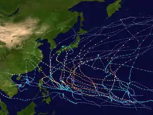
Typhoon Keith was the tenth of a record eleven super typhoons to develop during the unusually intense 1997 Pacific typhoon season. Originating from a near-equatorial trough on October 26, the precursor depression to Keith slowly organized into a tropical storm. After two days of gradual strengthening, the storm underwent a period of rapid intensification on October 30 as winds increased to 195 km/h (120 mph). On November 1, the storm further intensified into a super typhoon and later attained peak winds of 285 km/h (180 mph). The following day, the powerful storm passed between Rota and Tinian in the Northern Mariana Islands. After fluctuating in strength over the following few days, a steady weakening trend established itself by November 5 as the typhoon accelerated towards the northeast. On October 8, Keith transitioned into an extratropical cyclone and was last noted early the following day near the International Dateline.
| Typhoon (JMA scale) | |
|---|---|
| Category 5 super typhoon (SSHWS) | |
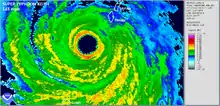
.png.webp) Typhoon Keith near peak intensity on November 1 as it neared the Northern Mariana Islands | |
| Formed | October 26, 1997 |
| Dissipated | November 11, 1997 |
| (Extratropical after November 8, 1997) | |
| Highest winds | 10-minute sustained: 205 km/h (125 mph) 1-minute sustained: 285 km/h (180 mph) |
| Lowest pressure | 910 hPa (mbar); 26.87 inHg |
| Fatalities | 1 |
| Damage | $15 million (1997 USD) |
| Areas affected | Japan, Northern Mariana Islands and Guam |
| Part of the 1997 Pacific typhoon season | |
Despite Typhoon Keith's close passage to the islands of Rota and Tinian as a powerful storm, neither island received sustained winds over 160 km/h (105 mph). However, these winds resulted in significant damage across the island chain. More than 800 homes were damaged or destroyed by the storm and losses amounted to $15 million (1997 USD). There were no reports of fatalities in relation to the storm; however, one person was injured.
Meteorological history

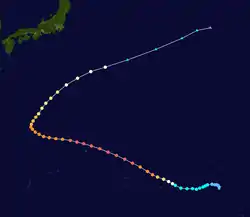
Typhoon Keith originated during the third week of October 1997 from a near-equatorial trough near the Marshall Islands. Along with its Southern Hemisphere twin, convection persisted around a weak low-level circulation, beginning on October 18. Slowly tracking westward, the system remained fairly disorganized before conditions allowed it to develop. By October 26, convection consolidated around the center of circulation and symmetrical outflow became established over the storm. Later that day, the JTWC issued a Tropical Cyclone Formation Alert (TCFA) for the system as they anticipated development into a tropical cyclone.[1] Hours later, the Japan Meteorological Agency (JMA) began monitoring the system as a tropical depression.[2] Despite favorable conditions, the low initially failed to develop further, prompting the issuance of a second TCFA on October 27. Later that day, the JTWC issued their first advisory on the depression, classifying it as 29W.[1]
Early on October 28, the depression intensified into a tropical storm, at which time it was named Keith by the JTWC. Tracking west-northwestward in response to a subtropical ridge, the storm slowly intensified at roughly half the rate initially forecast. However, on October 30, the storm suddenly underwent a period of rapid intensification, with sustained winds increasing from 100 km/h (65 mph) to 195 km/h (120 mph) in a 24‑hour span. Additionally, the barometric pressure decreased by 43 mbar (hPa; 1.27 inHg) during this time. Throughout the following day, the typhoon continued to intensify, becoming a super typhoon – a storm with winds of at least 240 km/h (150 mph) – late on October 31. Later, the system attained its peak winds of 285 km/h (180 mph) and an estimated pressure of 878 mbar (hPa; 25.93 inHg).[1] According to the JMA, however, Keith's peak ten-minute sustained winds were 205 km/h (125 mph) and the pressure was 910 mbar (hPa; 26.87 inHg).[2]
Maintaining super typhoon status, Keith moved through the Northern Mariana Islands between 0600–1200 UTC on November 2 with winds of 260 km/h (160 mph). The center of the typhoon moved between the islands of Rota and Tinian; however, it was discovered that the storm had a very compact field of intense hurricane-force winds, estimated to be 55 km (35 mi) across. After moving through the islands, Keith briefly weakened below super typhoon status on November 3 as the eye became partially obscured due to an eyewall replacement cyclone. However, it re-attained winds of 250 km/h (155 mph) the following day as it began to turn towards the north and later northeast. Once the storm completed its turn, Keith accelerated and steadily weakened as it entered the westerly flow north of the ridge previously steering it westward. Early on October 8, the storm transitioned into an extratropical cyclone as it was downgraded to a tropical storm.[1] The extratropical remnants of Keith were last noted by the JMA on October 9 near the International Dateline.[2]
Impact

Prior to the storm's arrival, more than 1,000 residents evacuated to storm shelters set up in the Northern Marianas Islands. Women who were more than seven months pregnant were also urged to check into hospitals, as doctors warned that changes in pressure could trigger labor.[3]
On November 2, Typhoon Keith passed through the 95 km (60 mi) wide channel between Rota and Tinian. Despite the storm's close passage between both islands, the maximum sustained winds above 115 mph (185 km/h) did not extend far enough out to reach either island. However, maximum sustained winds on Saipan were 158 km/h (98 mph) with gust to 175 km/h (109 mph). On Rota, winds reached 93 km/h (58 mph) with gust to 130 km/h (81 mph). On Tinian winds reached 111 km/h (69 mph) with gust to 130 km/h (81 mph). The strongest winds reported across Guam were 66 km/h (41 mph) with gust to 101 km/h (63 mph).[4]
Across the Northern Mariana Islands, more than 800 homes were damaged or destroyed and power was lost to most of the islands, leaving roughly 25,000 people without electricity.[1][5] Most of the damage took place on Saipan, where 130 homes were destroyed, 436 had major damage, and 226 others received minor damage. On Rota, 24 homes were destroyed and 156 others were damaged to varying degrees.[4] Despite the severity of damage, there were no reports of loss of life and only one injury in relation to the typhoon.[3] Throughout the Northern Mariana Islands, monetary losses from Keith amounted to $15 million (1997 USD).[4]
In the wake of the typhoon, President Bill Clinton declared the Mariana Islands as a disaster area, allowing the affected islands to receive government aid.[6] Red Cross workers were deployed to the islands to assist with relief efforts days after the storm.[7] Typhoon Keith was one of 23 events in the United States during the 1997-98 El Niño event which warranted federal aid; combined, the disasters cost $289.1 million, of which $5,813,784 was attributed to Keith.[8]
In Japan, one person were killed in a high wave by Keith.[9]
References
- Joint Typhoon Warning Center (1998). "Super Typhoon Keith (29W) Preliminary Report" (PDF). Naval Meteorology and Oceanography Command. Retrieved July 21, 2010.
- "Japan Meteorological Agency Best Tracks for 1997". Japan Meteorological Agency. 1998. Archived from the original (TXT) on July 9, 2011. Retrieved July 21, 2010.
- Associated Press (November 3, 1997). "Super Typhoon Keith plows through Northern Marianas". Pittsburgh Post-Gazette. p. 3. Retrieved July 21, 2010.
- "Guam Event Report: Typhoon". National Climatic Data Center. 1998. Archived from the original on July 21, 2010. Retrieved July 21, 2010.
- Staff Writer (November 3, 1997). "Super typhoon strikes islands". Beaver Country Times. p. 7. Retrieved July 21, 2010.
- "Disaster Area: Typhoon Keith in the North Mariana Islands". Louisiana Office of Student Financial Assistance. 1997. Retrieved July 21, 2010.
- Jeff Kass and J.J. Pope (November 18, 1997). "Red Cross Official Works in Guam". Los Angeles Times. Retrieved September 24, 2010.
- The Associated Press (April 4, 1998). "El Niño-Caused Federal Disasters". The Washington Post. Retrieved September 24, 2010.
- "1997年 台風第25号 (Keith) : TY9725". tydb.bosai.go.jp (in Japanese). Retrieved 2020-08-04.
External links
| Wikimedia Commons has media related to Typhoon Keith. |
- JMA General Information of Typhoon Keith (9725) from Digital Typhoon
- JMA Best Track Data (Graphics) of Typhoon Keith (9725)
- JMA Best Track Data (Text)
- JTWC Best Track Data of Super Typhoon 29W (Keith)
- 29W.KEITH from the U.S. Naval Research Laboratory
