Typhoon Mirinae (2009)
Typhoon Mirinae (pronounced [mi.ɾi.nɛ̝]), known in the Philippines as Typhoon Santi, was the 34th depression and the 14th typhoon in the 2009 Pacific typhoon season. It came several weeks after Typhoons Ketsana and Parma devastated the Philippines, thus adding additional damage wrought by the two typhoons.
| Typhoon (JMA scale) | |
|---|---|
| Category 2 typhoon (SSHWS) | |
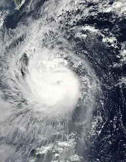 Typhoon Mirinae near landfall in the Philippines on October 30 | |
| Formed | October 25, 2009 |
| Dissipated | November 3, 2009 |
| Highest winds | 10-minute sustained: 150 km/h (90 mph) 1-minute sustained: 165 km/h (105 mph) |
| Lowest pressure | 955 hPa (mbar); 28.2 inHg |
| Fatalities | 162 total |
| Damage | $295 million (2009 USD) |
| Areas affected | Mariana Islands, Philippines, Vietnam, Cambodia, Laos, Thailand |
| Part of the 2009 Pacific typhoon season | |
Meteorological history
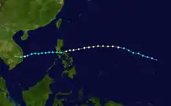
Early on October 10, 2009, the Joint Typhoon Warning Center (JTWC) reported that an area of convection was developing over an elongated and broad low level circulation center within a monsoon trough about 500 km, 315 miles to the southeast of Pohnpei.[1] The low level circulation center was located under a region of favourable divergence, however it was located in area of moderate to high vertical windshear which was hampering the low level circulation centers attempts to organize.[1] Over the next couple of days the vertical windshear relaxed and as a result convection started to develop further with a Tropical Cyclone Formation Alert being issued by the JTWC late on October 25 after the Japan Meteorological Agency (JMA) had designated the disturbance as a weak tropical depression.[2] The JTWC then designated the depression as 23W early the next morning as there had been an increase in convection consolidating near a developing low level circulation center. The JTWC then reported later that day that the depression had intensified into a Tropical Storm, however the JMA did not follow suit until early the next day when they assigned the international name of Mirinae to the storm as it passed over the island of Rota in the Northern Mariana Islands. As Mirinae entered the Philippine Area of Responsibility on October 28, the PAGASA assigned Mirinae the local name "Santi", the nineteenth named storm of the Philippines. Mirinae intensified steadily, eventually becoming a Category 2 typhoon, with peak winds of 105 mph (165 km/h). Due to increasing wind shear and its fast movement, Mirinae didn't intensify further. At this time Mirinae turned to the south-west, which it tracked for several days until its landfall along the province of Quezon at the night of October 30, with Mirinae as a Category 2 typhoon. As it left the Philippines, Mirinae has weakened to a tropical storm, with winds of 65 mph. It trekked the South China Sea, with Mirinae not intensifying beyond tropical storm force due to increasing wind shear and decreasing sea surface temperatures, as well as cooler and more stable air along the area. It ultimately made landfall on Vietnam on November 2, as a Category 1 typhoon. Mirinae quickly dissipated inland the same day.
Preparations
Northern Mariana Islands
| Hurricane warning levels |
|---|
| Hurricane Warning |
|
Hurricane conditions expected within 36 hours. |
| Hurricane Watch |
|
Hurricane conditions possible within 48 hours. |
| Tropical Storm Warning |
| Tropical storm conditions expected within 36 hours. |
| Tropical Storm Watch |
| Tropical storm conditions possible within 48 hours. |
| Storm Surge Warning |
| Life-threatening storm surge possible within 36 hours. |
| Storm Surge Watch |
| Life-threatening storm surge possible within 48 hours. |
| Extreme Wind Warning |
| Winds reaching Category 3 status or higher likely (issued two hours or less before onset of extreme winds). |
Early on October 26, the National Weather Service Weather Forecast Office in Tiyan, Guam placed Guam, Rota, Tinian and Saipan under a tropical storm watch which meant that tropical storm force winds were possible on the islands within 48 hours.[3] They then upgraded the watch for Rota, Tinian and Saipan to a Tropical Storm Warning as tropical storm force winds were now expected on the islands within 24 hours.[4] These warnings and watches were kept in force until they were cancelled early the next day after the tropical depression had moved away and intensified into a tropical storm.[5]
Philippines
Signal no. 3 was raised all over the parts of Southern Luzon, including Metro Manila, early in the morning of Friday even though the storm was far away. Ships that will travel were canceled as early as Friday for the preparation for the typhoon. Flights in and outside the Philippines were also canceled due to the typhoon. Signal no. 2 was raised across the Central Luzon and Bicol Region and Signal no. 1 was raised over northern Visayas and southern provinces of Northern Luzon. It had brought extreme winds in its passage.
Highest Public Storm Warning Signal
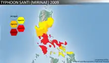
| PSWS# | Luzon | Visayas | Mindanao |
|---|---|---|---|
| 3 | Metro Manila, Bataan, Bulacan, Rizal, Cavite, Batangas, Laguna, Quezon including Polilio Island, Camarines Provinces, Catanduanes, Marinduque, Mindoro Provinces, Lubang Island | None | None |
| 2 | Zambales, Tarlac, Pampanga, Nueva Ecija, Aurora, Quirino, Romblon, Albay | None | None |
| 1 | Pangasinan, La Union, Benguet, Nueva Vizcaya, Ifugao, Isabela, Sorsogon, Masbate | Northern Samar, Northern Panay | None |
Vietnam
The tropical storm roared toward Vietnam on November 1 after battering the Philippine capital and surrounding provinces, leaving 20 people dead in a region still soggy from three recent storms. Typhoon Mirinae weakened November 1 as it headed over the South China Sea. Vietnamese Prime Minister, Nguyễn Tấn Dũng, ordered residents to begin evacuating high-risk areas of five coastal provinces and ordered Vietnamese fishermen in the South China Sea to seek shelter immediately. Along with the Philippines, Vietnam was still recovering from Typhoon Ketsana, which brought the Philippine capital, Manila, its worst flooding in 40 years and went on to kill more than 160 people in Vietnam in late September, 2009.[6]
Mirinae made landfall in the coastal province of Phu Yen on November 2. More than 100 people were killed in the subsequent flooding.[6][7]
Impact
Philippines
Throughout the Philippines, Mirinae killed 39 people and left roughly $100.1 million in damage.[8]
See also
References
- "Significant Tropical Weather Advisory for the Western and Southern Pacific 2009-10-23 06z". Joint Typhoon Warning Center. 2009-10-23. Retrieved 2009-10-30.
- "Tropical Cyclone Formation Alert 2009-10-25 21z". Joint Typhoon Warning Center. 2009-10-25. Retrieved 2009-10-30.
- Roger Edson, Michael Middlebrooke (2009-10-26). "Tropical Depression 23W Advisory Number One". National Weather Service in Tiyan, Guam. Archived from the original on October 26, 2009. Retrieved 2009-11-01.CS1 maint: unfit URL (link)
- Roger Edson, Paul Stanko (2009-10-26). "Tropical Depression 23W Advisory Number Two". National Weather Service in Tiyan, Guam. Archived from the original on October 26, 2009. Retrieved 2009-11-01.CS1 maint: unfit URL (link)
- Roger Edson, Clint Simpson (2009-10-27). "Tropical Depression 23W Advisory Number Five". National Weather Service in Tiyan, Guam. Archived from the original on October 27, 2009. Retrieved 2009-11-01.CS1 maint: unfit URL (link)
- Hal Pierce (2009-11-03). "Hurricane Season 2009: Typhoon Mirinae (Western Pacific)". Goddard Space Flight Center. NASA. Retrieved 2018-07-03.
- Nadia McGill (2009-11-17). "Vietnam: ADRA aids survivors of Typhoon Mirinae". ReliefWeb. Retrieved 2018-07-03.
- "Statistical Data On Destructive Tropical Cyclones 2009" (2010), National Disaster Coordinating Council
- 2009 VIETNAM REPORT
- "Typhoon Mirinae Kills 123 in Vietnam as Floods Sweep Homes Away". Bloomberg. November 8, 2009.
External links
| Wikimedia Commons has media related to Typhoon Mirinae (2009). |
- JMA General Information of Typhoon Mirinae (0921) from Digital Typhoon
- JMA Best Track Data of Typhoon Mirinae (0921) (in Japanese)
- JTWC Best Track Data of Typhoon 23W (Mirinae)
- 23W.MIRINAE from the U.S. Naval Research Laboratory
 Typhoon Mirinae heads towards the Philippines at Wikinews
Tropical cyclones of the 2009 Pacific typhoon season | ||||||||||||||||||||||||||||||||||||||||||||||||||||||||||||||||||||||||||||||||||||
|---|---|---|---|---|---|---|---|---|---|---|---|---|---|---|---|---|---|---|---|---|---|---|---|---|---|---|---|---|---|---|---|---|---|---|---|---|---|---|---|---|---|---|---|---|---|---|---|---|---|---|---|---|---|---|---|---|---|---|---|---|---|---|---|---|---|---|---|---|---|---|---|---|---|---|---|---|---|---|---|---|---|---|---|---|
 |
| |||||||||||||||||||||||||||||||||||||||||||||||||||||||||||||||||||||||||||||||||||
| ||||||||||||||||||||||||||||||||||||||||||||||||||||||||||||||||||||||||||||||||||||