Typhoon Koppu (2009)
Typhoon Koppu, known in the Philippines as Typhoon Nando was a typhoon struck China in September 2009.
| Typhoon (JMA scale) | |
|---|---|
| Category 1 typhoon (SSHWS) | |
 Typhoon Koppu at peak intensity near Hong Kong on August 14, 2009 | |
| Formed | September 12, 2009 |
| Dissipated | September 16, 2009 |
| Highest winds | 10-minute sustained: 120 km/h (75 mph) 1-minute sustained: 140 km/h (85 mph) |
| Lowest pressure | 975 hPa (mbar); 28.79 inHg |
| Fatalities | 12 total, 9 missing |
| Damage | $313 million (2009 USD) |
| Areas affected | Macau, Hong Kong, China, Philippines |
| Part of the 2009 Pacific typhoon season | |
Meteorological history
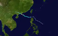
On September 9, an area of convectional cloudiness associated with the monsoon trough formed 370 km (230 mi) to the northwest of Palau.[1] Satellite imagery showed that a consolidating Low Level Circulation Centre (LLCC) with convection had started to develop and was wrapping toward the center. On September 11, the LLCC started to show improvement and was under moderate vertical shear with good westward outflow, but the JMA still upgraded the system to a minor tropical depression.[2] Early of September 12, PAGASA upgraded the system in their responsibility and assigned its local name, Nando. At 1500 UTC, PAGASA reported that the depression made its landfall over northern Palanan, Isabela of the Philippines. However both JMA and JTWC reported that the depression did not make landfall but only crossed the Luzon strait. Early of the next day, JTWC upgraded the system into a tropical depression. Early of September 13, both JMA and JTWC upgraded the system as a tropical storm and assigned its international name, Koppu. Koppu is a Japanese name, and it means Crater (コップ座) . In the afternoon, JMA reported that Koppu intensified into a severe tropical storm. On the 14th, the JMA reported that Koppu had intensified to a minimal typhoon, but the JTWC still kept Koppu as a tropical storm for the next few hours but later acknowledging the intensification and upgraded Koppu to a minimal typhoon. But the JTWC issued their final advisory early on September 15, as Koppu was moving over land, and was expected to dissipate quickly.
Impact

In Luzon, a 48-hour rainfall was experienced. In Visayas and Mindanao, a 24-hour rainfall was also experienced due to Nando's enhancing southwest monsoon. About 10 provinces were raised in signal warning no.1 from September 12 – September 13. Nando had triggered landslides resulting road closures and evacuations of some residents in Kalinga province. The storm then caused major flood in Luoding, People's Republic of China.[3]
References
- "JMA Tropical Cyclone Advisory 2009-09-11 18z". Japan Meteorological Agency. September 11, 2009. Archived from the original on August 29, 2009. Retrieved September 11, 2009.
- "Japan Meteorological Agency | Weather Maps". Archived from the original on September 16, 2009. Retrieved September 13, 2009.
- TimesofIndia.com. "TimesofIndia.com." Seven die as Typhoon Koppu hits China. Retrieved on October 9, 2009.
External links
| Wikimedia Commons has media related to Typhoon Koppu (2009). |
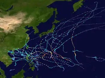
Tropical cyclones of the 2009 Pacific typhoon season | ||||||||||||||||||||||||||||||||||||||||||||||||||||||||||||||||||||||||||||||||||||
|---|---|---|---|---|---|---|---|---|---|---|---|---|---|---|---|---|---|---|---|---|---|---|---|---|---|---|---|---|---|---|---|---|---|---|---|---|---|---|---|---|---|---|---|---|---|---|---|---|---|---|---|---|---|---|---|---|---|---|---|---|---|---|---|---|---|---|---|---|---|---|---|---|---|---|---|---|---|---|---|---|---|---|---|---|
 |
| |||||||||||||||||||||||||||||||||||||||||||||||||||||||||||||||||||||||||||||||||||
| ||||||||||||||||||||||||||||||||||||||||||||||||||||||||||||||||||||||||||||||||||||
