Tyrifjorden
Tyrifjorden (Lake Tyri) is a lake in Norway. It lies 40 kilometres (25 mi) northwest of Oslo and is the nation's fifth largest lake with an area of 139 km2.[3] It has a volume of 13 km3, is 295 meters deep at its deepest, and lies 63 meters above sea level. The lake's primary source is the Begna river, which discharges into Tyrifjorden at Hønefoss where the river forms the waterfall of Hønefossen. Its primary outlet is at Vikersund near the lake's southwest corner, where Tyrifjorden discharges into the Drammenselva river.
| Tyrifjorden | |
|---|---|
 | |
 Tyrifjorden Location of Tyrifjorden in Viken  Tyrifjorden Tyrifjorden (Norway) | |
| Location | Viken, Norway |
| Coordinates | 60°2′N 10°8′E |
| Type | Fjord lake |
| Basin countries | Norway |
| Surface area | 139 km2 (54 sq mi) |
| Average depth | 97 m (318 ft) |
| Max. depth | 295 m (968 ft) |
| Water volume | 13.1 km3 (10,600,000 acre⋅ft) |
| Surface elevation | 62 m (203 ft) |
| References | [1] |
| Official name | Nordre Tyrifjord Wetlands System |
| Designated | 18 March 1996 |
| Reference no. | 802[2] |
Location
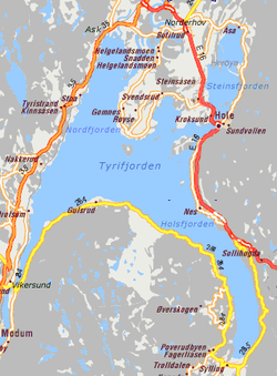
Tyrifjorden is located in the county of Viken and borders the municipalities of Hole, Lier, Modum, and Ringerike. Tyrifjorden is a landlocked fjord. It consists of a main body, Storfjorden, along with the Holsfjorden, Nordfjorden, and Steinsfjorden branches.
Branches
- Nordfjorden – This is the northernmost fjord arm of Tyrifjorden
- Steinsfjorden – This is the northeastern arm of Tyrifjorden
- Holsfjorden – This is the southeastern arm as well as being the longest and largest of the fjord branches
Islands
- Utøya - camp site for events
- Storøya – with a golf club
- Frognøya
The name

The Old Norse form of the name was just Tyri (or Tyrvi). This uncompounded name is also the first element in the name Tyristrand. The name is derived from the word tyri meaning "old/dead pine (wood)", referring specifically to the woods of the western side of the lake. The last element -fjorden (the finite form of fjord) is a later addition.
2011 shooting massacre
On 22 July 2011, an island in the lake, Utøya, was the site of a shooting spree during a youth camp held by the Norwegian Labour Party.
References
- Seppälä, Matti (2005), The Physical Geography of Fennoscandia, Oxford University Press, p. 145, ISBN 978-0-19-924590-1
- "Nordre Tyrifjord Wetlands System". Ramsar Sites Information Service. Retrieved 25 April 2018.
- "Statistisk årbok 2009: Geografisk oversikt" (in Norwegian). Ssb.no. Retrieved 15 May 2019.