U.S. Route 20 in Montana
U.S. Route 20 (US 20) is a west-east highway that travels from Targhee Pass at the Idaho state line to the west portion of Yellowstone National Park at the Wyoming state line.
| ||||
|---|---|---|---|---|
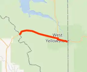
US 20 highlighted in red | ||||
| Route information | ||||
| Maintained by MDT | ||||
| Length | 9.680 mi[1] (15.578 km) | |||
| Major junctions | ||||
| West end | ||||
| East end | ||||
| Location | ||||
| Counties | Gallatin | |||
| Highway system | ||||
| ||||

Route description
US 20 enters Montana from Idaho at Targhee Pass at the Continental Divide. From there, it curves north and east down the mountain along a tree-lined, two-lane highway with a westbound climbing lane. An access road to the north provides access to Hebgen Lake. The highway then continues through Yellowstone National Park to Wyoming.
Major intersections
The entire route is in Gallatin County.
| Location | mi[1] | km | Destinations | Notes | |
|---|---|---|---|---|---|
| Continental Divide | 0.000 | 0.000 | Continuation into Idaho | ||
| Targhee Pass; Montana–Idaho line | |||||
| West Yellowstone | 9.318 | 14.996 | Western end of US 191/US 287 concurrency | ||
| Yellowstone National Park | 9.680 | 15.578 | West Entrance; closed December-April | ||
| 11.8 | 19.0 | Continuation into Wyoming; US 20/US 191/US 287 resume outside of Yellowstone National Park | |||
1.000 mi = 1.609 km; 1.000 km = 0.621 mi
| |||||
References
- Montana Department of Transportation (2013). "Montana Road Log" (PDF). Helena: Montana Department of Transportation. Retrieved September 13, 2014.
External links
- US 20, US 191, and US 287 in West Yellowstone via Corco Highways
| Previous state: Idaho |
Montana | Next state: Wyoming |
This article is issued from Wikipedia. The text is licensed under Creative Commons - Attribution - Sharealike. Additional terms may apply for the media files.