Underwood, Queensland
Underwood is a suburb in the City of Logan, Queensland, Australia.[2] In the 2016 census, Underwood had a population of 6,341 people.[1]
| Underwood Logan City, Queensland | |||||||||||||||
|---|---|---|---|---|---|---|---|---|---|---|---|---|---|---|---|
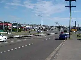 Logan Road, 2014 | |||||||||||||||
 Underwood | |||||||||||||||
| Coordinates | 27.6069°S 153.1127°E | ||||||||||||||
| Population | 6,341 (2016 census (suburb))[1] | ||||||||||||||
| • Density | 1,510/km2 (3,910/sq mi) | ||||||||||||||
| Postcode(s) | 4119 | ||||||||||||||
| Area | 4.2 km2 (1.6 sq mi) | ||||||||||||||
| Time zone | AEST (UTC+10:00) | ||||||||||||||
| Location |
| ||||||||||||||
| LGA(s) | Logan City | ||||||||||||||
| State electorate(s) | Waterford | ||||||||||||||
| Federal Division(s) | Rankin | ||||||||||||||
| |||||||||||||||
Geography
Underwood is located south-east of the Brisbane central business district in Queensland, Australia. Its local government area is the Logan City Council.
Logan Road, Kingston Road, Compton Road and surrounding area encompass the Underwood business centre which is a mixed-use urban development area incorporating the Underwood / Slacks Creek industrial estate, as well as retail, commerce, mechanical, education, health and office establishments.
The housing estates Arriva and Jacaranda are located in Underwood.
History
Underwood is situated in the Yugarabul traditional Aboriginal country of the Brisbane and surrounding regions.[3] Towards the south-east of Underwood towards Beenleigh is the Bundjalung traditional Aboriginal country.[4] The origin of the suburb name is from William Underwood who was an early property owner in the area.[5] William Underwood had established the Commercial Hotel, which operated from the early 1870s through to 1895 on land nearby Beenleigh Road. The suburb Underwood was gazetted in 1975 and was part of both Brisbane City Council and the former Shire of Albert before the creation of Logan City in the year 1978.[6]
In the 2011 census Underwood had a population of 5,328 people.[7]
In the 2016 census, Underwood had a population of 6,341 people.[1]
Transport
Underwood is accessible by road from the Pacific Motorway (M1). Public transport is available via the Springwood Bus Station along the South East Busway. The nearest train stations are the Kuraby Railway Station in the adjacent suburb of Kuraby, and Trinder Park Railway Station in the adjacent suburb of Woodridge.
Facilities
Operated by Logan City Council Libraries, the Logan North branch Library opened in 2008 and is located on the corner of Sports Drive and Springwood Road, Underwood.[8][9] Public WiFi is available.[8]
Education
There are no schools in Underwood. The nearest primary schools are Eight Mile Plains State School in neighbouring Eight Mile Plains to the north-west, Springwood Road State School in neighbouring Rochedale South to the north-east, and Kuraby State School in neighbouring Kuraby to the west. The nearest secondary schools are Rochedale State High School in neighbouring Rochedale to the north, Springwood State High School in neighbouring Springwood to the east, and Runcorn State High School in Runcorn to the west.[10]
Demographics
In the 2011 census, Underwood recorded a population of 5,328 people, 49.9% female and 50.1% male.[7] The median age of the Underwood population was 32 years, 5 years below the national median of 37. 59.6% of people living in Underwood were born in Australia. The other top responses for country of birth were New Zealand 6.3%, China 2.3%, England 2.2%, South Africa 1.9%, Korea, Republic of 1.8%. 67.7% of people spoke only English at home; the next most common languages were 4.5% Mandarin, 3% Cantonese, 2.2% Korean, 1.7% Arabic, 1.4% Hindi.[7]
References
- Australian Bureau of Statistics (27 June 2017). "Underwood (SSC)". 2016 Census QuickStats. Retrieved 20 October 2018.

- "Underwood – suburb in City of Logan (entry 45308)". Queensland Place Names. Queensland Government. Retrieved 12 October 2020.
- "AIATSIS code E66: Yugarabul". Federal government. Australian Institute of Aboriginal and Torres Strait Islander Studies. Retrieved 31 July 2020.
- "Bundjalung – Muurrbay Aboriginal Language and Culture Co-operative". muurrbay.org.au. Retrieved 19 December 2020.
- "History of Rochedale". Archived from the original on 28 April 2014. Retrieved 4 January 2012.
- "Underwood". Logan City Council. Archived from the original on 9 March 2020. Retrieved 13 April 2020.
- Australian Bureau of Statistics (31 October 2012). "Underwood (Logan City) (State Suburb)". 2011 Census QuickStats. Retrieved 28 February 2008.
- "Public Libraries Statistical Bulletin 2016-17" (PDF). Public Libraries Connect. State Library of Queensland. November 2017. p. 14. Archived (PDF) from the original on 30 January 2018. Retrieved 30 January 2018.
- "Logan North Library". Logan City Council. Archived from the original on 30 January 2018. Retrieved 30 January 2018.
- "Queensland Globe". State of Queensland. Retrieved 12 October 2020.
External links
| Wikimedia Commons has media related to Underwood, Queensland. |
- "Underwood". Queensland Places. Centre for the Government of Queensland, University of Queensland.