Unionville, Missouri
Unionville is a city in Putnam County, Missouri, United States. The population was 1,865 at the 2010 census. It is the county seat of Putnam County.[6]
Unionville, Missouri | |
|---|---|
 Location of Unionville, Missouri | |
| Coordinates: 40°28′35″N 93°0′22″W | |
| Country | United States |
| State | Missouri |
| County | Putnam |
| Area | |
| • Total | 2.00 sq mi (5.17 km2) |
| • Land | 2.00 sq mi (5.17 km2) |
| • Water | 0.00 sq mi (0.00 km2) |
| Elevation | 1,063 ft (324 m) |
| Population | |
| • Total | 1,865 |
| • Estimate (2019)[3] | 1,742 |
| • Density | 872.75/sq mi (336.90/km2) |
| Time zone | UTC−6 (Central (CST)) |
| • Summer (DST) | UTC−5 (CDT) |
| ZIP code | 63565 |
| Area code(s) | 660 |
| FIPS code | 29-75166[4] |
| GNIS feature ID | 0736357[5] |
History
Unionville was first named Harmony when established in 1853 as the county seat for Putnam County. Prior to that the county seat had moved several times, often with heated debate, thus the centralized location hoping to bring "harmony" to all concerned. (see Putnam County history for more details)
On May 22, 1962, Continental Airlines Flight 11, en route from O'Hare Airport in Chicago, Illinois to the downtown Kansas City, Missouri airport, crashed in a clover field north of Unionville, near Lake Thunderhead, killing all 37 passengers and 8 crew. Investigators subsequently determined that one of the jetliner's passengers, Thomas G. Doty, detonated a bomb inside the Boeing 707 in a suicide-for-insurance plot.
Geography and climate
Unionville is located at 40°28′35″N 93°0′22″W (40.476421, -93.006005).[7]
According to the United States Census Bureau, the city has a total area of 2.00 square miles (5.18 km2), all of it land.[8]
| Climate data for Unionville, Missouri (1981–2010) | |||||||||||||
|---|---|---|---|---|---|---|---|---|---|---|---|---|---|
| Month | Jan | Feb | Mar | Apr | May | Jun | Jul | Aug | Sep | Oct | Nov | Dec | Year |
| Average high °F (°C) | 34.9 (1.6) |
38.5 (3.6) |
51.9 (11.1) |
64.4 (18.0) |
73.6 (23.1) |
82.0 (27.8) |
86.1 (30.1) |
84.3 (29.1) |
77.1 (25.1) |
64.0 (17.8) |
50.3 (10.2) |
36.2 (2.3) |
61.9 (16.6) |
| Average low °F (°C) | 15.2 (−9.3) |
16.9 (−8.4) |
28.2 (−2.1) |
39.7 (4.3) |
50.0 (10.0) |
59.2 (15.1) |
63.6 (17.6) |
61.2 (16.2) |
53.2 (11.8) |
40.3 (4.6) |
29.7 (−1.3) |
16.7 (−8.5) |
39.5 (4.2) |
| Average precipitation inches (mm) | 1.14 (29) |
1.48 (38) |
2.88 (73) |
3.80 (97) |
4.05 (103) |
4.90 (124) |
5.70 (145) |
4.72 (120) |
3.90 (99) |
3.78 (96) |
2.62 (67) |
1.92 (49) |
40.90 (1,039) |
| Average snowfall inches (cm) | 6.0 (15) |
7.3 (19) |
2.2 (5.6) |
0.1 (0.25) |
0.0 (0.0) |
0.0 (0.0) |
0.0 (0.0) |
0.0 (0.0) |
0.0 (0.0) |
0.0 (0.0) |
1.5 (3.8) |
6.4 (16) |
23.6 (60) |
| Source: NOAA[9] | |||||||||||||
Demographics
| Historical population | |||
|---|---|---|---|
| Census | Pop. | %± | |
| 1860 | 227 | — | |
| 1870 | 462 | 103.5% | |
| 1880 | 772 | 67.1% | |
| 1890 | 1,118 | 44.8% | |
| 1900 | 2,050 | 83.4% | |
| 1910 | 2,000 | −2.4% | |
| 1920 | 1,765 | −11.7% | |
| 1930 | 1,811 | 2.6% | |
| 1940 | 2,052 | 13.3% | |
| 1950 | 2,050 | −0.1% | |
| 1960 | 1,896 | −7.5% | |
| 1970 | 2,075 | 9.4% | |
| 1980 | 2,178 | 5.0% | |
| 1990 | 1,989 | −8.7% | |
| 2000 | 2,041 | 2.6% | |
| 2010 | 1,865 | −8.6% | |
| 2019 (est.) | 1,742 | [3] | −6.6% |
| U.S. Decennial Census[10] | |||
2010 census
As of the census[2] of 2010, there were 1,865 people, 844 households, and 468 families living in the city. The population density was 932.5 inhabitants per square mile (360.0/km2). There were 1,009 housing units at an average density of 504.5 per square mile (194.8/km2). The racial makeup of the city was 97.1% White, 0.4% African American, 0.2% Native American, 0.7% Asian, 0.3% from other races, and 1.3% from two or more races. Hispanic or Latino of any race were 1.2% of the population.
There were 844 households, of which 28.6% had children under the age of 18 living with them, 39.2% were married couples living together, 12.2% had a female householder with no husband present, 4.0% had a male householder with no wife present, and 44.5% were non-families. 40.4% of all households were made up of individuals, and 21% had someone living alone who was 65 years of age or older. The average household size was 2.14 and the average family size was 2.86.
The median age in the city was 41.8 years. 24.2% of residents were under the age of 18; 7.4% were between the ages of 18 and 24; 21.9% were from 25 to 44; 23.9% were from 45 to 64; and 22.6% were 65 years of age or older. The gender makeup of the city was 46.5% male and 53.5% female.
2000 census
As of the census[4] of 2000, there were 2,041 people, 913 households, and 530 families living in the city. The population density was 1,025.0 people per square mile (396.0/km2). There were 1,048 housing units at an average density of 526.3 per square mile (203.3/km2). The racial makeup of the city was 99.17% White, 0.05% African American, 0.10% Asian, 0.15% from other races, and 0.54% from two or more races. Hispanic or Latino of any race were 1.03% of the population.
There were 913 households, out of which 26.8% had children under the age of 18 living with them, 43.6% were married couples living together, 10.3% had a female householder with no husband present, and 41.9% were non-families. 38.6% of all households were made up of individuals, and 22.6% had someone living alone who was 65 years of age or older. The average household size was 2.17 and the average family size was 2.89.
In the city the population was spread out, with 24.2% under the age of 18, 8.1% from 18 to 24, 22.5% from 25 to 44, 19.8% from 45 to 64, and 25.4% who were 65 years of age or older. The median age was 40 years. For every 100 females, there were 85.2 males. For every 100 females age 18 and over, there were 77.9 males.
The median income for a household in the city was $19,978, and the median income for a family was $28,796. Males had a median income of $22,402 versus $16,741 for females. The per capita income for the city was $11,881. About 18.7% of families and 18.6% of the population were below the poverty line, including 21.3% of those under age 18 and 13.8% of those age 65 or over.
Education
Public education in Unionville is administered by Putnam County R-I School District.[11] Unionville has a lending library, the Putnam County Public Library.[12]
Notable people
- Bill Jackson - Children's TV host and cartoonist.
- Clare Magee - former U.S. Congressman
- John C. McKinley - former Missouri Lieutenant Governor.
- James K. Weatherford (1850-1935) - Oregon attorney and politician
References
- "2019 U.S. Gazetteer Files". United States Census Bureau. Retrieved July 26, 2020.
- "U.S. Census website". United States Census Bureau. Retrieved 2012-07-08.
- "Population and Housing Unit Estimates". United States Census Bureau. May 24, 2020. Retrieved May 27, 2020.
- "U.S. Census website". United States Census Bureau. Retrieved 2008-01-31.
- "US Board on Geographic Names". United States Geological Survey. 2007-10-25. Retrieved 2008-01-31.
- "Find a County". National Association of Counties. Archived from the original on May 31, 2011. Retrieved 2011-06-07.
- "US Gazetteer files: 2010, 2000, and 1990". United States Census Bureau. 2011-02-12. Retrieved 2011-04-23.
- "US Gazetteer files 2010". United States Census Bureau. Archived from the original on January 12, 2012. Retrieved 2012-07-08.
- "NOWData - NOAA Online Weather Data". National Oceanic and Atmospheric Administration. Retrieved May 4, 2013.
- "Census of Population and Housing". Census.gov. Retrieved June 4, 2015.
- "Homepage". Putnam County R-I School District. Retrieved 5 June 2019.
- "Missouri Public Libraries". PublicLibraries.com. Archived from the original on 10 June 2017. Retrieved 5 June 2019.
External links
- Historic maps of Unionville in the Sanborn Maps of Missouri Collection at the University of Missouri
Municipalities and communities of Putnam County, Missouri, United States | ||
|---|---|---|
| City | 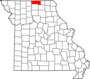 Map of Missouri highlighting Putnam County | |
| Villages | ||
| Townships |
| |
| CDP | ||
| Unincorporated communities | ||
| Ghost towns | ||
| ||
| Authority control |
|---|