Potosi, Missouri
Potosi is a city in Washington County, Missouri, United States. Potosi is seventy-two miles southwest of St. Louis. The population was 2,660 at the 2010 census. It is the county seat of Washington County.[6] The city was founded sometime between 1760 and 1780 as "Mine à Breton" or Mine au Breton, and later renamed by Moses Austin for the Bolivian silver-mining city of Potosí. [7]
Potosi, Missouri | |
|---|---|
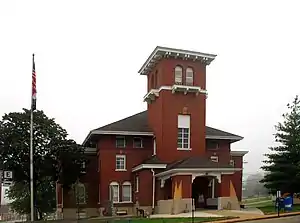 Washington County Courthouse | |
| Motto(s): A City for All Seasons | |
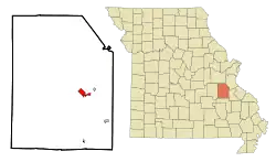 Location of Potosi, Missouri | |
| Coordinates: 37°56′11″N 90°47′16″W[1] | |
| Country | United States |
| State | Missouri |
| County | Washington |
| Incorporated | 1826 |
| Area | |
| • Total | 2.33 sq mi (6.03 km2) |
| • Land | 2.33 sq mi (6.03 km2) |
| • Water | 0.00 sq mi (0.00 km2) |
| Elevation | 902 ft (275 m) |
| Population | |
| • Total | 2,660 |
| • Estimate (2019)[4] | 2,577 |
| • Density | 1,106.96/sq mi (427.47/km2) |
| Time zone | UTC-6 (Central (CST)) |
| • Summer (DST) | UTC-5 (CDT) |
| ZIP code | 63664 |
| Area code(s) | 573 |
| FIPS code | 29-59330[5] |
Geography
According to the United States Census Bureau, the city has a total area of 2.33 square miles (6.03 km2), all land.[8]
History
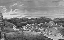
A lead mining settlement at this spot, "Mine à Breton" or Mine au Breton, was founded between 1760 and 1780 by Francis Azor, of Brittany, France. Moses Austin came here in 1798 with his family, including his son Stephen F. Austin. Moses obtained a grant of 7,153 arpents of land from the Spanish Empire and started large-scale mining operations, building his town to support it. Moses named the town after Potosí in Bolivia, which was famous for its vast silver mines. Austin's tomb and the foundation of his home Durham Hall can still be seen. Another mining entrepreneur in Potosi at the time of Moses Austin was James Bryan. Firmin Rene Desloge, who emigrated from Nantes, France in 1822 as the progenitor of the Desloge Family in America, located in Potosi and established a mercantile, distillery, fur trading and lead smelting business. The Desloge lead mining business Desloge Lead Company and later Desloge Consolidated Lead Company was later relocated to Bonne Terre, MO and also Desloge, MO by his son Firmin V. Desloge.[9][10]
Potosi was designated county seat in 1814.[11]
The Potosi Correctional Center, which opened in 1989, housed Missouri's death row and the state's executions were handled at the prison until 2005. The Potosi Center conducted all but one of the 62 Missouri executions between 1989 when capital punishment was reinstated and 2005 when executions were moved 25 miles east to the Eastern Reception, Diagnostic and Correctional Center in Bonne Terre, Missouri.[12]
Woodcut artist Tom Huck grew up in Potosi, where he has taken inspiration from many of the region's local legends and folk tales. In 1998, Huck released "2 Weeks in August: 14 Rural Absurdities", a suite of 14 woodcut prints based on bizarre tales from the town's history.
The George Cresswell Furnace, Palmer Historic Mining District, Washington County Courthouse, and Washington State Park CCC Historic District are listed on the National Register of Historic Places.[13][14]
Demographics
| Historical population | |||
|---|---|---|---|
| Census | Pop. | %± | |
| 1860 | 548 | — | |
| 1870 | 897 | 63.7% | |
| 1880 | 715 | −20.3% | |
| 1890 | 599 | −16.2% | |
| 1900 | 638 | 6.5% | |
| 1910 | 772 | 21.0% | |
| 1920 | 984 | 27.5% | |
| 1930 | 1,279 | 30.0% | |
| 1940 | 2,017 | 57.7% | |
| 1950 | 2,359 | 17.0% | |
| 1960 | 2,805 | 18.9% | |
| 1970 | 2,761 | −1.6% | |
| 1980 | 2,528 | −8.4% | |
| 1990 | 2,683 | 6.1% | |
| 2000 | 2,662 | −0.8% | |
| 2010 | 2,660 | −0.1% | |
| 2019 (est.) | 2,577 | [4] | −3.1% |
| U.S. Decennial Census[15] | |||
2010 census
As of the census[3] of 2010, there were 2,660 people, 1,114 households, and 657 families living in the city. The population density was 1,141.6 inhabitants per square mile (440.8/km2). There were 1,230 housing units at an average density of 527.9 per square mile (203.8/km2). The racial makeup of the city was 95.2% White, 2.2% African American, 0.4% Native American, 0.4% Asian, 0.3% from other races, and 1.6% from two or more races. Hispanic or Latino of any race were 1.6% of the population.
There were 1,114 households, of which 32.2% had children under the age of 18 living with them, 37.0% were married couples living together, 17.8% had a female householder with no husband present, 4.2% had a male householder with no wife present, and 41.0% were non-families. 36.4% of all households were made up of individuals, and 14.9% had someone living alone who was 65 years of age or older. The average household size was 2.23 and the average family size was 2.86.
The median age in the city was 39.1 years. 24.2% of residents were under the age of 18; 8.8% were between the ages of 18 and 24; 23.9% were from 25 to 44; 24.3% were from 45 to 64; and 18.7% were 65 years of age or older. The gender makeup of the city was 44.1% male and 55.9% female.
2000 census
As of the census[5] of 2000, there were 2,662 people, 1,103 households, and 677 families living in the city. The population density was 1,218.9 people per square mile (471.5/km2). There were 1,211 housing units at an average density of 554.5 per square mile (214.5/km2). The racial makeup of the city was 95.60% White, 2.14% African American, 0.45% Native American, 0.15% Asian, 0.23% from other races, and 1.43% from two or more races. Hispanic or Latino of any race were 0.83% of the population.
There were 1,103 households, out of which 33.3% had children under the age of 18 living with them, 40.1% were married couples living together, 17.7% had a female householder with no husband present, and 38.6% were non-families. 35.7% of all households were made up of individuals, and 17.8% had someone living alone who was 65 years of age or older. The average household size was 2.30 and the average family size was 2.97.
In the city, the population was spread out, with 26.7% under the age of 18, 9.2% from 18 to 24, 25.9% from 25 to 44, 20.2% from 45 to 64, and 18.0% who were 65 years of age or older. The median age was 36 years. For every 100 females there were 81.5 males. For every 100 females age 18 and over, there were 75.9 males.
The median income for a household in the city was $17,702, and the median income for a family was $23,958. Males had a median income of $31,548 versus $16,976 for females. The per capita income for the city was $12,417. About 28.1% of families and 31.4% of the population were below the poverty line, including 42.7% of those under age 18 and 13.9% of those age 65 or over.
Government and infrastructure
The United States Postal Service operates the Potosi Post Office.[16]
The Potosi Correctional Center of the Missouri Department of Corrections is located in an unincorporated area in Washington County, near Potosi.[17] The prison houses male death row inmates.[18]
Education
Public education in Potosi is administered by the Potosi R-III School District.[19]
Potosi has a public library, the Washington County Library.[20]
Notable people
- Moses Austin, American settlement colonizer in St. Genevieve, Missouri and father of Stephen Austin of the Republic of Texas
- Firmin Rene Desloge, progenitor of the Desloge Family in America
- Firmin V. Desloge, Founder Desloge Consolidated Lead Company and Desloge, Missouri and Bonne Terre, Missouri
- Donne Wall, baseball player
- Tom Huck, artist/printmaker
- Dylan Coleman, pitcher for the Kansas City Royals
References
- U.S. Geological Survey Geographic Names Information System: Potosi, Missouri
- "2019 U.S. Gazetteer Files". United States Census Bureau. Retrieved July 26, 2020.
- "U.S. Census website". United States Census Bureau. Retrieved 2012-07-08.
- "Population and Housing Unit Estimates". United States Census Bureau. May 24, 2020. Retrieved May 27, 2020.
- "U.S. Census website". United States Census Bureau. Retrieved 2008-01-31.
- "Find a County". National Association of Counties. Retrieved 2011-06-07.
- "Archived copy". Archived from the original on 2015-12-20. Retrieved 2010-02-11.CS1 maint: archived copy as title (link)
- "US Gazetteer files 2010". United States Census Bureau. Archived from the original on 2012-01-25. Retrieved 2012-07-08.
- Christopher D Desloge, second great-grandson of Firmin Rene Desloge
- The Desloge Chronicles, 2011, by Christopher D Desloge
- Eaton, David Wolfe (1918). How Missouri Counties, Towns and Streams Were Named. The State Historical Society of Missouri. p. 370.
- Missouri moves execution site to Bonne Terre – Associated Press – March 29, 2005 (via Prisontalk.com)
- "National Register Information System". National Register of Historic Places. National Park Service. July 9, 2010.
- "National Register of Historic Places Listings". Weekly List of Actions Taken on Properties: 10/24/11 through 10/28/11. National Park Service. 2011-11-04.
- "Census of Population and Housing". Census.gov. Retrieved June 4, 2015.
- "Post Office Location - POTOSI Archived 2010-11-08 at the Wayback Machine." United States Postal Service. Retrieved on September 18, 2010.
- "Institutional Facilities Archived 2010-05-27 at the Wayback Machine." Missouri Department of Corrections. Retrieved on September 18, 2010. "Potosi Correctional Center (C-5)" "11593 State Highway O Mineral Point, MO 63660"
- Lombardi, George, Richard D. Sluder, and Donald Wallace. "The Management of Death-Sentenced Inmates: Issues, Realities, and Innovative Strategies Archived 2010-05-27 at the Wayback Machine." Missouri Department of Corrections. 8-9. Retrieved on September 18, 2010.
- "Homepage". Potosi R-Iii School District. Retrieved 4 June 2019.
- "Missouri Public Libraries". PublicLibraries.com. Archived from the original on 10 June 2017. Retrieved 2 June 2019.
External links
- History of Potosi
- Historic maps of Potosi in the Sanborn Maps of Missouri Collection at the University of Missouri
Municipalities and communities of Washington County, Missouri, United States | ||
|---|---|---|
| Cities | 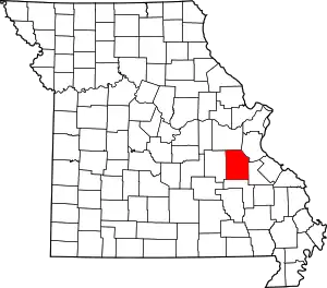 Map of Missouri highlighting Washington County | |
| Villages | ||
| Townships | ||
| Unincorporated communities |
| |
| Ghost towns | ||
| Footnotes | ‡This populated place also has portions in an adjacent county or counties | |
| ||
| Authority control |
|---|