Upper Hungary
Upper Hungary is the usual English translation of Felvidék (literally: "Upland"), the Hungarian term for the area that was historically the northern part of the Kingdom of Hungary, now mostly present-day Slovakia.[2][3][4][5] The region has also been called Felső-Magyarország (literally: "Upper Hungary"; Slovak: Horné Uhorsko).
Part of a series on the |
|---|
| History of Hungary |
 |
|
|
Part of a series on the |
|---|
| History of Slovakia |
 |
|
|
During the Habsburg–Ottoman wars, Upper Hungary meant only the northeastern parts of the Hungarian Kingdom. The northwestern regions (present-day western and central Slovakia) belonged to Lower Hungary. Sometime during the 18th or 19th centuries, Upper Hungary began to imply the whole northern regions of the kingdom. The population of Upper Hungary was mixed and mainly consisted of Slovaks, Hungarians, Germans and Ruthenians. The first complex demographic data are from the 18th century, in which Slovaks constituted the majority population in Upper Hungary.[6] Slovaks called this territory "Slovensko" (Slovakia), which term appears in written documents from the 15th century, but it was not precisely defined[7] and the region inhabited by Slovaks held no distinct legal, constitutional, or political status within Upper Hungary.[8]
Etymology
Historical usage
Historically there are different meanings:
1. The older Hungarian term Felső-Magyarország (literally: "Upper Hungary"; Slovak: Horné Uhorsko; German: Oberungarn; Ukrainian: Верхня Угорщина; Russian: Верхняя Венгрия) formally referred to what is today Slovakia in the 16th-18th centuries and informally to all the northern parts of the Kingdom of Hungary in the 19th century.
2. There are some 16th-century sources which refer to the Slovak-inhabited territory of the Kingdom of Hungary as "Sclavonia" or "Slováky", names that distinguish the region ethnically as well as geographically.[9]
3. The Hungarian Felvidék (literally: "Upper Country", "Upland", "Highland", or perhaps more accurately "Upper Landscape" or "Upper Countryside"; Slovak: Horná zem; German: Oberland; Yiddish: אױבערלאַנד) has had several informal meanings:
- In the parts of the 18th century and throughout the 19th century, it was usually used:
- to denote the mountainous northern part of the Kingdom of Hungary as opposed to the southern lowlands
- more generally, to denote regions or territories situated at a higher altitude than the settlement of the speaker
- as a synonym for the then-meaning of Felső-Magyarország
- After World War I, the meaning in the Hungarian language was restricted to Slovakia and Carpathian Ruthenia, and after World War II to Slovakia only. At the same time, the word felvidék remains a common Hungarian noun applied to areas at higher elevations, e.g., Balaton-felvidék,[10] a hilly region and national park[11] adjacent to Lake Balaton.
Modern usage
After World War I, the meaning of Felvidék in the Hungarian language (Felső-Magyarország was not used anymore) was restricted to the Slovakian and Carpathian Ruthenian parts of Czechoslovakia. Today the term Felvidék is sometimes used in Hungary when speaking about Slovakia, and it is exclusively (and anachronistically) used in Hungarian historical literature when speaking about the Middle Ages, i.e., before the name actually came into existence. The three counties of the region that remained in Hungary after World War I, however, are never called Upper Hungary today, only Northern Hungary (Észak-Magyarország). Any use of the word Felvidék to denote all of modern Slovakia is considered offensive by Slovaks,[12] and inappropriate by some Hungarians,[13] but it is now commonly used by the sizeable Hungarian minority in the southern border-zone of Slovakia[14] to identify the Hungarian-majority areas where they live.[15][16] Some of them call themselves felvidéki magyarok, i.e. the "Upland Hungarians." The word felvidék is also used as a component of the toponym Balaton-felvidék, describing the hilly area north of Lake Balaton, with no connection to the historical Upper Hungary.[17]
History
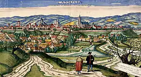
Middle Ages
The term Upper Hungary often occurs in publications on history as a somewhat-anachronistic translation of other, earlier (then Latin) designations denoting approximately the same territory. Some of the other terms were Partes Danubii septentrionales (Territories to the north of the Danube) or Partes regni superiores (Upper parts of the Kingdom). The actual name "Upper Hungary" arose later from the latter phrase.
In the 15th century, the "Somorja (Šamorín), Nagyszombat (Trnava), Galgóc (Hlohovec), Nyitra (Nitra), Léva (Levice), Losonc (Lučenec), Rimaszombat (Rimavská Sobota), Rozsnyó (Rožňava), Jászó (Jasov), Kassa (Košice), Gálszécs (Sečovce), Nagymihály (Michalovce)" line was the northern "boundary" of the Hungarian ethnic area.[18]
Affiliation to Hungary
The Principality of Nitra emerged in the 8th century and developed into an independent Slavic state; although the polity may have lost its independence when it was still at the stage of development.[19][20] In the early 9th century, the polity was situated on the north-western territories of present-day Slovakia.
16th - 17th centuries
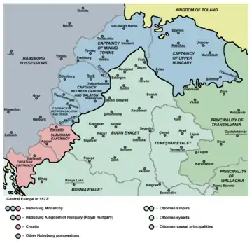
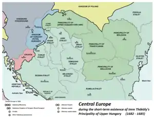
The term emerged approximately after the conquest of today's Hungary by the Ottomans in the 16th century when Felső-Magyarország (German: Oberungarn; Slovak: Horné Uhorsko) referred to present-day eastern Slovakia and the adjacent territories of today's Hungary and Ukraine that were not occupied by the Ottoman Empire. That territory formed a separate military district (the "Captaincy of Upper Hungary" (1564–1686) headquartered in Kassa/Kaschau/Košice) within Royal Hungary. At that time, present-day western Slovakia, and sometimes also the remaining territories of Royal Hungary to the south of it, were called Lower Hungary (Hungarian: Alsó-Magyarország; German: Niederungarn; Slovak: Dolné Uhorsko).
It was briefly a separate vassal state of the Ottoman Empire under Imre Thököly in the 1680s.
This usage occurs in many texts up to around 1800 – for example, the renowned mining school of Schemnitz/Selmecbánya/Banská Štiavnica in present-day central Slovakia was founded in "Lower" Hungary (not in "Upper" Hungary) in the 18th century and Pozsony (today's Bratislava) was also referred to as being in "Lower" Hungary in the late 18th century.
18th century - early 20th century
From the 18th century (in many texts however only after around 1800) until 1920, the territory of the Kingdom of Hungary north of the Tisza and the Danube, which comprised present-day Slovakia, Carpathian Ruthenia, and approximately the counties of Nógrád, Heves, and Borsod-Abaúj-Zemplén, was informally called either "Upper Hungary" or "Upland" (Felső-Magyarország or Felvidék). Although not strictly defined, the name Felvidék became commonplace to the point that at least one publication concerning the area used it as its title.[21] Other nations used the terms "Upper Hungary" (for the northern part of the Kingdom), "Slovakia" (only for the territory predominantly inhabited by the Slovaks), and "Ruthenia" (the territory predominantly inhabited by the Ruthenians) in parallel. The Slovaks themselves called the territories of the Kingdom of Hungary to the south of Slovakia Dolná zem ("Lower Land").
In the course of the creation of Czechoslovakia at the end of World War I, Czechoslovakia originally demanded that all of the so-called Upper Hungary be added to Czechoslovak territory (i.e. including the territory between the Tisza River and present-day Slovakia). The claim for its acquisition, however, was not based on the whole area having a single common name, "Upper Hungary", but on the presence of a Slovak minority in the region.
Demographics
Population in the 18th century
In 1720 of the 63 largest towns on the territory of present-day Slovakia with at least 100 taxpaying households 40 had Slovak majority, 14 German and 9 Hungarian majority.[22]
Population in the 19th century
The first ethnic data of whole Hungarian Kingdom by county was published in 1842. According to this survey the total population of the counties in Upper Hungary exceeded 2.4 million, with the following ethnic distribution: 59.5% Slovaks, 22% Magyars, 8.3% Ruthenians, 6.7% Germans and 3.6% Jews.[23]
Population in the 20th century
Upper Hungary included the counties of Pozsony, Nyitra, Bars, Hont, Trencsén, Turóc, Árva, Liptó, Zólyom, Gömör és Kis-Hont, Szespes, Abaúj-Torna, Sáros and Zemplén.[6] In the last census of 1910 in the Kingdom of Hungary, which was based on native language, Slovak language users were a majority in many of these counties.[24]
References
- Kniha (Matica slovenská) ISSN 1336-5436, 2008: p. 16.
- Gardiner, Duncan (1991). German Towns in Slovakia and Upper Hungary: A Genealogical Gazetteer. ISBN 978-0-929871-02-8. Archived from the original on 2016-04-01. Retrieved 2016-01-05.
- Berger, Tilman (July 2003). "Slovaks in Czechia — Czechs in Slovakia" (PDF). International Journal of the Sociology of Language. 2003 (162): 19–39. doi:10.1515/ijsl.2003.035. ISSN 0165-2516.
- Hirsch, Eric (April 1997). "Voices from the Black Box: Folk Song, Boy Scouts and the Construction of Folk Nationalist Hegemony in Hungary, 1930–1944". Antipode. 29 (2): 197–215. doi:10.1111/1467-8330.00043. ISSN 1467-8330.
- Demarée, G.R.; Ogilvie, A.E.J. (2001). "Bons Baisers d'Islande: Climatic, Environmental, and Human Dimensions Impacts of the Lakagígar Eruption (1783-1784) in Iceland". In Jones, Philip D (ed.). History and Climate: Memories of the Future?. Kluwer Academic Publishers. p. 234. ISBN 0306465892.
- Kocsis, Károly; Kocsisné Hodosi, Eszter (1998). Ethnic Geography of the Hungarian Minorities in the Carpathian Basin. Budapest: Geographical Research Institute Research Centre for Earth Sciences. p. 41. ISBN 9637395849.
- Kováč, Dušan (2011). "Slovakia, the Slovaks and their history". In Teich, Mikuláš; Kováč, Dušan (eds.). Slovakia in history. Cambridge University Press. p. 3. ISBN 0521802539.
- Felak, James Ramon (1994). At the Price of the Republic: Hlinka's Slovak People's Party, 1929–1938. University of Pittsburgh Press. p. 3–. ISBN 978-0-8229-3779-1.
- Felak 1994, p. 219
- Balaton-felvidéki Nemzeti Park
- Balaton Uplands National Park
- E.g., Morvay, Peter (3 April 2006). "Orbán rečnil, Duray len počúval" [Viktor Orbán made a speech, Miklós Duray only listened]. SME (in Slovak)..
- Käfer, István (2002). "Terminologia Hungaro-Sclavonica: a magyar-szlovák interetnikus összefüggések történeti vizsgálatának terminológiai kérdései". In Rozsondai, Marianne (ed.). Jubileumi csokor Csapodi Csaba tiszteletére: Tanulmányok (in Hungarian). Budapest: Argumentum. ISBN 9634462065..
- Lanstyák, István; Simon, Szabolcs, eds. (1998). Tanulmányok a magyar–szlovák kétnyelvűségről [Studies on Slovak-Hungarian bilinguism] (in Hungarian). Bratislava: Kalligram. ISBN 80-7149-193-4..
- Liszka, József (2014). "Felvidék". In Urbán, Zsolt (ed.). A (cseh)szlovákiai magyarok lexikona — Csehszlovákia megalakulásától napjainkig [Encyclopedia of Hungarians in (Czecho-)Slovakia — From the foundation of Czechoslovakia until our days] (in Hungarian). Bratislava: Slovenské pedagogické nakladateľstvo – Mladé letá. ISBN 978-80-10-00399-0. External link in
|chapter=(help) - See, e.g., the systematic differentiated use of the words Felvidék and Szlovákia in the Hungarian-language newspaper Új Szó published by the Hungarians in Slovakia.
- Budai, Tamás; et al. (1999). A Balaton-felvidék földtana : magyarázó a Balaton-felvidék földtani térképéhez (1:50,000) [Geology of the Balaton Highland: explanation to the geological map of the Balaton Highland] (in Hungarian). Budapest: Geological and Geophysical Institute of Hungary (MÁFI). ISBN 9636712247..
- Kocsis & Kocsisné Hodosi 1998, p. 42
- Ďurianová, Marta (2004-07-12). "Nitra: from fields to factories". The Slovak Spectator. Retrieved 2008-04-22.
- Poulik, Josef (1978). "The Origins of Christianity in Slavonic Countries North of the Middle Danube Basin". World Archaeology. Taylor&Francis Ltd. 10 (2): 158–171. doi:10.1080/00438243.1978.9979728. JSTOR 124226.
- Grünwald, Béla (1878). A Felvidék: politikai tanulmány (in Hungarian). Budapest: Ráth Mór..
- Kocsis & Kocsisné Hodosi 1998, p. 47
- Kocsis & Kocsisné Hodosi 1998, p. 52
- Magyar Királyi Központi Statisztikai Hivatal (1912). A magyar szent korona országainak 1910. évi népszámlálása [1910 Census of the Lands of the Hungarian Crown] (in Hungarian). I. Budapest: Athenaeum. p. 22.