Utsjoki
Utsjoki (Northern Sami: Ohcejohka; Inari Sami: Uccjuuhâ; Skolt Sami: Uccjokk; Norwegian: Utsjok) is a municipality in Finland, the northernmost in the country. It is in Lapland and borders Norway as well as the municipality of Inari. The municipality was founded in 1876. It has a population of 1,213 (31 July 2020)[2] and covers an area of 5,372.00 square kilometres (2,074.14 sq mi) of which 227.51 km2 (87.84 sq mi) is water.[1] The population density is 0.24 inhabitants per square kilometre (0.62/sq mi).
Utsjoki
Utsjoki – Ohcejohka | |
|---|---|
Municipality | |
| Utsjoen kunta Utsjoki kommun | |
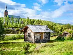 Utsjoki Church and a log cabin | |
 Coat of arms | |
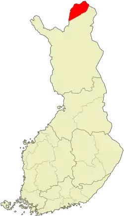 Location of Utsjoki in Finland | |
| Coordinates: 69°54′N 027°01′E | |
| Country | |
| Region | Lapland |
| Sub-region | Northern Lapland |
| Charter | 1876 |
| Government | |
| • Municipal manager | Vuokko Tieva-Niittyvuopio |
| Area (2018-01-01)[1] | |
| • Total | 5,372.00 km2 (2,074.14 sq mi) |
| • Land | 5,144.27 km2 (1,986.21 sq mi) |
| • Water | 227.51 km2 (87.84 sq mi) |
| Area rank | 10th largest in Finland |
| Population (2020-07-31)[2] | |
| • Total | 1,213 |
| • Rank | 291st largest in Finland |
| • Density | 0.24/km2 (0.6/sq mi) |
| Population by native language | |
| • Finnish | 51.6% (official) |
| • Swedish | 0.2% |
| • Sami | 46.6% |
| • Others | 1.7% |
| Population by age | |
| • 0 to 14 | 13.8% |
| • 15 to 64 | 65.8% |
| • 65 or older | 20.3% |
| Time zone | UTC+02:00 (EET) |
| • Summer (DST) | UTC+03:00 (EEST) |
| Municipal tax rate[5] | 20.75% |
| Website | www.utsjoki.fi |
Utsjoki has two official languages: Finnish and Northern Sami. It is the municipality in Finland with the largest portion of official Sami speakers; 46.6% of the population.[3]
The border to Norway follows the river Teno which flows into the Arctic Sea. The northernmost village in Finland and in the European Union is Nuorgam which is also the northernmost land border crossing in the world.
Utsjoki is at the northern end of highway 4, the longest highway in Finland. The European route E75 runs along the Sami Bridge further to Norway.
The Kevo nature reserve is in the municipality. It covers a territory of 712 km2 (275 sq mi) and there is a 63 km (39 mi) long hiking trail. The trail partly follows the edge of the Kevo canyon.
Villages in Utsjoki
Nuorgam, Utsjoki centre, Nuvvus, Dalvadas, Outakoski, Rovisuvanto, Karigasniemi and Kaamasmukka.
Climate
Despite being over three degrees north of the Arctic Circle, Utsjoki, like most of Finland, has a subarctic climate (Köppen Dfc). Being the northernmost municipality in Finland, Utsjoki is a very cold place with an annual average temperature below freezing. Utsjoki is also the driest place in Finland, as the average annual precipitation varies between 371 and 433 millimetres (14.6 and 17.0 in), depending on the topography. The driest year on record was 1986 when only 234 millimetres (9.2 in) of precipitation fell at the Outakoski weather station.[6]
The "midnight sun" is above the horizon from 17 May to 28 July (73 days), and the period with continuous night lasts a bit shorter, polar night from 26 November to 15 January (51 days).
| Climate data for Utsjoki Kevo, 1981–2010 normals, records 1959–present | |||||||||||||
|---|---|---|---|---|---|---|---|---|---|---|---|---|---|
| Month | Jan | Feb | Mar | Apr | May | Jun | Jul | Aug | Sep | Oct | Nov | Dec | Year |
| Record high °C (°F) | 6.2 (43.2) |
6.3 (43.3) |
9.2 (48.6) |
15.7 (60.3) |
30.5 (86.9) |
32.8 (91.0) |
33.4 (92.1) |
31.5 (88.7) |
24.3 (75.7) |
13.7 (56.7) |
8.7 (47.7) |
7.1 (44.8) |
33.4 (92.1) |
| Average high °C (°F) | −9.2 (15.4) |
−8.1 (17.4) |
−3.2 (26.2) |
2.4 (36.3) |
7.9 (46.2) |
14.7 (58.5) |
18.3 (64.9) |
15.4 (59.7) |
9.6 (49.3) |
2.3 (36.1) |
−4.4 (24.1) |
−7.5 (18.5) |
3.2 (37.8) |
| Daily mean °C (°F) | −14.0 (6.8) |
−12.8 (9.0) |
−8.2 (17.2) |
−2.5 (27.5) |
3.7 (38.7) |
9.6 (49.3) |
13.1 (55.6) |
10.7 (51.3) |
5.7 (42.3) |
−0.5 (31.1) |
−8.3 (17.1) |
−12.3 (9.9) |
−1.3 (29.7) |
| Average low °C (°F) | −19.1 (−2.4) |
−18.0 (−0.4) |
−13.8 (7.2) |
−7.7 (18.1) |
−0.5 (31.1) |
5.1 (41.2) |
8.5 (47.3) |
6.5 (43.7) |
2.3 (36.1) |
−3.4 (25.9) |
−12.5 (9.5) |
−17.3 (0.9) |
−5.8 (21.6) |
| Record low °C (°F) | −48.2 (−54.8) |
−47.9 (−54.2) |
−39.1 (−38.4) |
−31.9 (−25.4) |
−20.9 (−5.6) |
−3.4 (25.9) |
−0.1 (31.8) |
−3.9 (25.0) |
−11.9 (10.6) |
−28.9 (−20.0) |
−36.1 (−33.0) |
−41.4 (−42.5) |
−48.2 (−54.8) |
| Average precipitation mm (inches) | 27 (1.1) |
24 (0.9) |
21 (0.8) |
25 (1.0) |
27 (1.1) |
50 (2.0) |
72 (2.8) |
57 (2.2) |
38 (1.5) |
39 (1.5) |
28 (1.1) |
25 (1.0) |
433 (17) |
| Source 1: FMI climatological normals for Finland 1981–2010[7] | |||||||||||||
| Source 2: record highs and lows[8] | |||||||||||||
| Climate data for Utsjoki Outakoski, 1981–2010 normals | |||||||||||||
|---|---|---|---|---|---|---|---|---|---|---|---|---|---|
| Month | Jan | Feb | Mar | Apr | May | Jun | Jul | Aug | Sep | Oct | Nov | Dec | Year |
| Average precipitation mm (inches) | 22 (0.9) |
20 (0.8) |
16 (0.6) |
19 (0.7) |
17 (0.7) |
38 (1.5) |
61 (2.4) |
54 (2.1) |
35 (1.4) |
38 (1.5) |
29 (1.1) |
22 (0.9) |
371 (14.6) |
| Source: FMI open data, 1981–2010[9] | |||||||||||||
Gallery
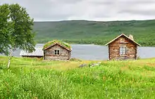 Mantojärvi, near Utsjoki village
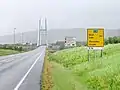 Utsjoki seen from Norway
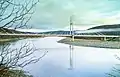 The Sami Bridge connects Utsjoki to Norway
Notable people
- Inger-Mari Aikio-Arianaick, writer, born in Utsjoki in 1961.
- Pigga Keskitalo, Sámi academic, born in Utsjoki in 1972.
- Helvi Poutasuo (1943–2017), teacher, translator, editor, politician
- Irja Seurujärvi-Kari (born 1947), politician and academic
References
- "Area of Finnish Municipalities 1.1.2018" (PDF). National Land Survey of Finland. Retrieved 30 January 2018.
- "Suomen virallinen tilasto (SVT): Väestön ennakkotilasto [verkkojulkaisu]. Heinäkuu 2020" (in Finnish). Statistics Finland. Retrieved 13 September 2020.
- "Population according to language and the number of foreigners and land area km2 by area as of 31 December 2008". Statistics Finland's PX-Web databases. Statistics Finland. Retrieved 29 March 2009.
- "Population according to age and gender by area as of 31 December 2008". Statistics Finland's PX-Web databases. Statistics Finland. Retrieved 28 April 2009.
- "List of municipal and parish tax rates in 2011". Tax Administration of Finland. 29 November 2010. Retrieved 13 March 2011.
- "FMI normals 1981-2010" (PDF). fmi.fi. Retrieved 26 April 2016.
- "FMI open data". FMI. Retrieved 26 April 2016.
- "FMI open data". FMI. Retrieved 21 March 2020.
External links
![]() Media related to Utsjoki at Wikimedia Commons
Media related to Utsjoki at Wikimedia Commons
- Municipality of Utsjoki (in Finnish and Northern Sami)
- Hotel Luossajohka Utsjoki
| Municipalities |  | |
|---|---|---|
| Former municipalities | ||