Valentine Formation
The Valentine Formation is a geologic formation or member within the Ogallala unit with outcrops in South Dakota, Nebraska, and Kansas. It preserves fossils dating to the Neogene period and is particularly noted for Canid fossils.[1][2]
| Valentine Formation Stratigraphic range: Neogene | |
|---|---|
| Type | Formation / Member |
| Unit of | Ogallala Formation |
| Overlies | Eroded and weathered Miocene units Pierre Shale (Nebraska) and Niobrara Chalks |
| Location | |
| Region | South Dakota, Nebraska, Kansas |
| Country | United States |
| Type section | |
| Named for | Valentine Railway Quarries, Valentine, Nebraska |
At the beginning of the Ogallala deposits washing out from the rising Rocky Mountains into the central plains states, the members of the Pierre Shale[3] and Niobrara Formation outcrop had been largely exposed in their present range. The Niobrara had been incised by the present river systems, but to only a fraction of the present depths. Therefore, the earliest Ogallala deposits, the Valentine, filled in these shallower valleys; but there was no continuous exposure over the range of the eastern outcrop of the Ogallala.[4][5] Isolated exposures of the Valentine phase have been located along the Niobrara outcrop and quarried along the Smoky Hill River, Solomon River, Republican River, and Niobrara River where these watersheds have cut deeply down through the Niobrara Chalk into the Carlile Shale.
The Valentine Formation presents gray to gray-green, unconsolidated, fine-to-coarse grained, fluvial siltstone, channel sandstone, and gravel eroded from uplift of the Rocky Mountains as well as locally eroded materials,[6] particularly Niobrara chalk cobbles and chalk sand.[7] The specific index stone for the Valentine is the lenticular beds of grey-green opaline sandstone. The silicate cementation makes the opaline sandstone denser and harder than any other local stone, and it has been quarried as ballast, road gravel, and dam outflow rip-rap (e.g., Cedar Bluff Reservoir, Sherman Dam[8]). The opaline sandstone sandstone has had limited use in construction, and example being the structures in the city park of Hill City, Kansas. Beds of flint or chert can be found higher in the Valentine and the weathered Niobrara Chalk is also silicified where there is contact with these beds in the Valentine.
Gallery
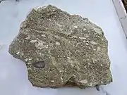 Valentine opaline sandstone with white Niobrara pebbles, Rush County, Kansas
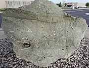 Valentine opaline sandstone, Hays, Kansas
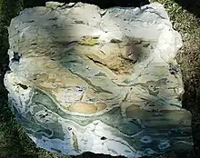 Valentine-contact opalized Niobrara
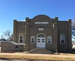 Bogue, Kansas Township Hall
See also
References
- Robert L. Evander, Emanuel County Junior College (1986). "Carnivores of the Railway and Quarries Local Fauna". Transactions of the Nebraska Academy of Sciences and Affiliated Societies Nebraska Academy of Sciences. University of Nebraska - Lincoln.
- "Geologic Unit: Valentine". National Geologic Database. Geolex — Significant Publications. United States Geological Survey. Retrieved 2020-06-05.
- Alvin Leonard Lugn, University of Nebraska - Lincoln (1938). "The Nebraska State Geological Survey and the "Valentine Problem"". American Journal of Science. University of Nebraska - Lincoln.
- Alvin R. Leonard and Delmar W. Berry (1961). Geology and Ground-water Resources of Southern Ellis County and Parts of Trego and Rush Counties, Kansas, Bulletin 149. University of Kansas Publications, State Geological Survey of Kansas. p. Geomorphology / Stream Development.
At the close of Pliocene time, the area from the Rocky Mountains to the Flint Hills was a nearly featureless aggradational plain crossed by streams flowing toward the east. During the formation of this [Ogallala] plain in central Kansas the Cretaceous [Niobrara] rocks were buried under a mantle of debris, ...
CS1 maint: uses authors parameter (link) - John C. Frye, A. Byron Leonard, and Ada Swineford (1956). Stratigraphy of the Ogallala Formation (Neogene) of Northern Kansas, Bulletin 118. University of Kansas Publications, State Geological Survey of Kansas. p. Methods of Correlation.
... and the configuration of the lower surface indicates location of preexisting valleys and the most likely locale of earliest sedimentation. ... Therefore, it is expectable that the lowest, hence oldest, members be present in low areas of the bedrock, ... The relation of the configuration of the erosional surface at the base of the Ogallala to the stratigraphy of the formation has been fully recognized only recently (Merriam and Frye, 1954).
CS1 maint: uses authors parameter (link) - "Ogallala Group". USGS.
- John C. Frye, A. Byron Leonard, and Ada Swineford (1956). Stratigraphy of the Ogallala Formation (Neogene) of Northern Kansas, Bulletin 118. University of Kansas Publications, State Geological Survey of Kansas. p. Measured Sections.CS1 maint: uses authors parameter (link)
- "Sherman Dam: Constructed 1959-1962". United States. Bureau of Reclamation. p. 25.
