Carlile Shale
The Carlile Shale is a Turonian age Upper/Late Cretaceous series shale geologic formation in the central-western United States, including in the Great Plains region of Colorado, Kansas, Nebraska, New Mexico, North Dakota, South Dakota, and Wyoming.[2]
| Carlile Shale Stratigraphic range: Turonian ~93.9–89.8 Ma | |
|---|---|
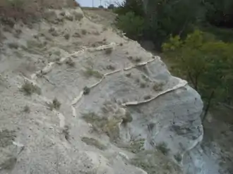 Rare exposure of the Fairport Chalk member of the Carlile Shale in southern Ellis County, Kansas | |
| Type | Geological formation |
| Unit of | Colorado Group (lower); or Benton Formation |
| Sub-units | Juana Lopez (CO, NM) Codell Sandstone Blue Hill Shale Fairport Chalk |
| Underlies | Niobrara Formation |
| Overlies | Greenhorn Limestone |
| Thickness | 170–230 feet (52–70 m) |
| Lithology | |
| Primary | Shale, chalky to carbonaceous |
| Other | Limestone Sandstone Siltstone Septarians Bentonite |
| Location | |
| Coordinates | 38.376°N 104.979°W |
| Region | Mid-continental |
| Country | |
| Type section | |
| Named for | Carlile Spring and Carlile Station, 21 mi west of Pueblo, Colorado[1] |
| Named by | Gilbert |
| Year defined | 1896 |
 Carlile Shale (the United States) 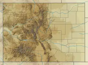 Carlile Shale (Colorado) | |
It is composed of marine deposits of the generally retreating phase (hemi-cycle) of the Greenhorn cycle of the Western Interior Seaway, which followed the advancing phase of the same cycle that formed the underlying Graneros Shale and Greenhorn Formation.[3] As such, the lithology progresses from open ocean chalky shale (with thin limestones) to increasing carbonaceous shale to near-shore sandstone. There is a discontinuity between the top of the Carlile and the Niobrara sequence.[4]
Viewing and access
- Auto touring in Kansas
West from mile 195, Interstate 70 leaves the level bench on the Fencepost limestone for low, broad residual hills of Carlile Shale. These low hills are mostly the Fairport Chalk member, its thin limestone beds making it more resistant than the Blue Hill Shale member. In the distance to the northwest, the Fort Hays Limestone escarpment is visible, the slopes of which are grass-covered Blue Hill Shale.
Taking the Yocemento Avenue Exit 153 south, Yocemento lies at the base of the Fort Hays bluffs. Between Yocemento and Ellis, Old Hwy 40 passes over grass-covered slump blocks of Blue Hill Shale. The Codell Sandstone member is not present in this part of the county. 14 miles south of Ellis, on Monroe St./Ellis Ave., a broad slope of blue-gray Blue Hill Shale is exposed; the soil in this area "blew out" during the Dust Bowl; many orange-tinted septarian boulders may be seen from the road.
Fossils
Upper Turonian series Plesiosaur remains are among the fossils that have been recovered from the strata of its Blue Hill Shale Member in Kansas.[5] The Carlile in eastern South Dakota contains shark teeth, fossil wood and leaves, and ammonites.[6]
History of investigation
The Carlile Shale was first named by Grove Karl Gilbert for exposures at Carlile Spring, located about 21 miles (34 km) west of Pueblo, Colorado. He described it as a medium gray shale, capped with limestone or sandstone, and assigned it to the Benton Group.[7] By 1931, William Walden Rubey and his coinvestigators had mapped it into Kansas[8] and the Black Hills. Rubey also first assigned it to the Colorado Group.[9] C.H. Dane assigned it to the Mancos Shale in New Mexico in 1948.[10]
Gallery
 The lower 25 feet (7.6 m) of the Fairport Chalk member in southern Ellis County, Kansas.
.jpg.webp)
 The bare Blue Hill Shale slopes at Yocemento as they appeared in 1873.
The bare Blue Hill Shale slopes at Yocemento as they appeared in 1873.
See also
- Volcanic mineralization of the Greenhorn cycle:
- Bentonite, sedimentary volcanic ash (named for the original Graneros/Greenhorn/Carlile classification), generally showing some weathered iron stain in the Colorado Group
- Pyrite, precipitation of volcanic sulfuric acid with oceanic iron as FeS2
- Limonite, pyrite in limestone weathered to HFeO2 (rust stain or yellow ochre)
- Selenite, CaSO4 associated with Bentonite seams and ochre[11]
References
- "Geologic Unit: Carlile". National Geologic Database. Geolex — Unit Summary. United States Geological Survey. Retrieved 2017-02-03.
- USGS.gov: Mineral resources of the Niobrara and Carlile Formations
- McLane, Michael (1982). "Upper Cretaceous Coastal Deposits in South-Central Colorado--Codell and Juana Lopez Members of Carlile Shale". AAPG Bulletin. 66. doi:10.1306/03B59A26-16D1-11D7-8645000102C1865D.
- King, Norman R. (1974). "The Carlile-Niobrara contact and lower Niobrara strata near El Vado, New Mexico". New Mexico Geological Society Field Conference Series. 24: 259–266. CiteSeerX 10.1.1.513.8769. Retrieved 23 November 2020.
- Jstor.org: "Probable plesiosaur remains from the Blue Hill Shale (Carlile Formation)" in Kansas", Kansas Academy of Science, 2009.
- William A. Cobban and E.A. Merewether (1983), Stratigraphy and paleontology of mid-Cretaceous rocks in Minnesota and contiguous areas. USGS Professional Paper 1253.
- Gilbert, G.K. (1896). "The underground water of the Arkansas Valley in eastern Colorado". In Walcott, C.D. (ed.). Seventeenth Annual report of the United States Geological Survey to the Secretary of the Interior, 1895-1896. 17. pp. 551–601. doi:10.3133/ar17_2.
- Rubey, W.W.; Bass, N.W. (1925). "The geology of Russell County, Kansas, with special reference to oil and gas resources". Kansas Geological Survey Bulletin. 10 (1): 1–86.
- Rubey, W.W. (1931). "Lithologic studies of fine-grained Upper Cretaceous sedimentary rocks of the Black Hills region". U.S. Geological Survey Professional Paper. 165-A: A1–A54. doi:10.3133/pp165A.
- Dane, C.H. (1948). "Geology and oil possibilities of the eastern side of the San Juan Basin, Rio Arriba County, New Mexico". U.S. Geological Survey Oil and Gas Investigations Map. OM-78. Retrieved 23 November 2020.
- Alvin R. Leonard and Delmar W. Berry (1961). Geology and Ground-water Resources of Southern Ellis County and Parts of Trego and Rush Counties, Kansas, Bulletin 149. University of Kansas Publications, State Geological Survey of Kansas. p. Geologic Formations in Relation to Ground Water.
The upper 175 feet of the Carlile is classed as the Blue Hill Shale member. Most of it is blue-gray fissile argillaceous shale that contains selenite crystals and flakes of bright yellow ochre.
CS1 maint: uses authors parameter (link)
