Valley Falls, Kansas
Valley Falls is a city in Jefferson County, Kansas, United States. As of the 2010 census, the city population was 1,192.[6]
Valley Falls, Kansas | |
|---|---|
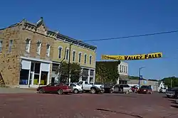 Business district of Valley Falls (2014) | |
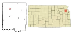 Location within Jefferson County and Kansas | |
 KDOT map of Jefferson County (legend) | |
| Coordinates: 39°20′35″N 95°27′38″W | |
| Country | United States |
| State | Kansas |
| County | Jefferson |
| Founded | 1854 |
| Platted | 1855 |
| Incorporated | 1869 |
| Area | |
| • Total | 0.71 sq mi (1.84 km2) |
| • Land | 0.70 sq mi (1.82 km2) |
| • Water | 0.01 sq mi (0.01 km2) |
| Elevation | 942 ft (287 m) |
| Population | |
| • Total | 1,192 |
| • Estimate (2019)[3] | 1,153 |
| • Density | 1,637.78/sq mi (632.79/km2) |
| Time zone | UTC-6 (CST) |
| • Summer (DST) | UTC-5 (CDT) |
| ZIP code | 66088 |
| Area code | 785 |
| FIPS code | 20-73300 [4] |
| GNIS ID | 0478332 [5] |
| Website | valleyfalls.org |
History
Valley Falls was originally called Grasshopper Falls, from the falls in the Grasshopper River (now known as the Delaware River).[7] The first settlement was made there in 1854, and the town was platted in 1855. Many of the town's streets were named after women pioneer settlers.[8]
Geography
Valley Falls is located at 39°20′35″N 95°27′38″W (39.342936, -95.460584).[9] According to the United States Census Bureau, the city has a total area of 0.78 square miles (2.02 km2), of which, 0.77 square miles (1.99 km2) is land and 0.01 square miles (0.03 km2) is water.[10]
Climate
The climate in this area is characterized by hot, humid summers and generally mild to cool winters. According to the Köppen Climate Classification system, Valley Falls has a humid subtropical climate, abbreviated "Cfa" on climate maps.[11]
Demographics
| Historical population | |||
|---|---|---|---|
| Census | Pop. | %± | |
| 1860 | 202 | — | |
| 1870 | 603 | 198.5% | |
| 1880 | 1,016 | 68.5% | |
| 1890 | 1,180 | 16.1% | |
| 1900 | 1,078 | −8.6% | |
| 1910 | 1,129 | 4.7% | |
| 1920 | 1,218 | 7.9% | |
| 1930 | 1,238 | 1.6% | |
| 1940 | 1,241 | 0.2% | |
| 1950 | 1,139 | −8.2% | |
| 1960 | 1,193 | 4.7% | |
| 1970 | 1,169 | −2.0% | |
| 1980 | 1,189 | 1.7% | |
| 1990 | 1,253 | 5.4% | |
| 2000 | 1,254 | 0.1% | |
| 2010 | 1,192 | −4.9% | |
| 2019 (est.) | 1,153 | [3] | −3.3% |
| U.S. Decennial Census | |||
Valley Falls is part of the Topeka, Kansas Metropolitan Statistical Area.
2010 census
As of the census[2] of 2010, there were 1,192 people, 444 households, and 290 families residing in the city. The population density was 1,548.1 inhabitants per square mile (597.7/km2). There were 518 housing units at an average density of 672.7 per square mile (259.7/km2). The racial makeup of the city was 96.2% White, 2.1% African American, 1.0% Native American, 0.1% Asian, 0.1% from other races, and 0.5% from two or more races. Hispanic or Latino of any race were 1.8% of the population.
There were 444 households, of which 36.3% had children under the age of 18 living with them, 50.7% were married couples living together, 7.7% had a female householder with no husband present, 7.0% had a male householder with no wife present, and 34.7% were non-families. 31.1% of all households were made up of individuals, and 16.9% had someone living alone who was 65 years of age or older. The average household size was 2.44 and the average family size was 3.04.
The median age in the city was 40.8 years. 26.1% of residents were under the age of 18; 6.3% were between the ages of 18 and 24; 24.6% were from 25 to 44; 24.6% were from 45 to 64; and 18.5% were 65 years of age or older. The gender makeup of the city was 46.5% male and 53.5% female.
2000 census
As of the census[4] of 2000, there were 1,254 people, 485 households, and 297 families residing in the city. The population density was 1,682.6 people per square mile (645.6/km2). There were 521 housing units at an average density of 699.1 per square mile (268.2/km2). The racial makeup of the city was 96.89% White, 0.72% African American, 1.12% Native American, 0.40% Asian, 0.16% from other races, and 0.72% from two or more races. Hispanic or Latino of any race were 0.64% of the population.
There were 485 households, out of which 33.2% had children under the age of 18 living with them, 48.7% were married couples living together, 8.7% had a female householder with no husband present, and 38.6% were non-families. 34.6% of all households were made up of individuals, and 21.9% had someone living alone who was 65 years of age or older. The average household size was 2.44 and the average family size was 3.21.
In the city, the population was spread out, with 28.0% under the age of 18, 8.3% from 18 to 24, 25.6% from 25 to 44, 19.5% from 45 to 64, and 18.7% who were 65 years of age or older. The median age was 37 years. For every 100 females, there were 98.4 males. For every 100 females age 18 and over, there were 92.9 males.
The median income for a household in the city was $34,018, and the median income for a family was $41,500. Males had a median income of $28,000 versus $21,771 for females. The per capita income for the city was $15,626. About 5.1% of families and 7.9% of the population were below the poverty line, including 5.2% of those under age 18 and 19.6% of those age 65 or over.
Government
It is governed by a mayor/council form of government. There are five council members. The day-to-day business of the city is conducted by the city administrator, and a part-time city clerk, paid employees of the city.
Education
Valley Falls has one local grade school serving grades 1-8 and one local high school serving grades 9-12. The local sports teams are known as the Dragons and their school colors are black and gold.
Notable people
- Puella Dornblaser, temperance activist, lived in Valley Falls and edited at a newspaper in Oskaloosa
- Fred Marsh, professional baseball player, born in Valley Falls in 1924.[12]
- King O'Malley, member of the Australian House of Representatives in the early 20th century, although he also claimed he was born in Quebec, Canada
- George Stafford, former chairman for the Interstate Commerce Commission was born and schooled in Valley Falls
References
- "2019 U.S. Gazetteer Files". United States Census Bureau. Retrieved July 24, 2020.
- "U.S. Census website". United States Census Bureau. Retrieved 2012-07-06.
- "Population and Housing Unit Estimates". United States Census Bureau. May 24, 2020. Retrieved May 27, 2020.
- "U.S. Census website". United States Census Bureau. Retrieved 2008-01-31.
- "US Board on Geographic Names". United States Geological Survey. 2007-10-25. Retrieved 2008-01-31.
- "2010 City Population and Housing Occupancy Status". U.S. Census Bureau. Retrieved April 6, 2011.
- Kansas State Historical Society (1916). Biennial Report of the Board of Directors of the Kansas State Historical Society. Kansas State Printing Plant. pp. 209.
- Blackmar, Frank Wilson (1912). Kansas: A Cyclopedia of State History, Volume 2. Standard Publishing Company. pp. 840.
- "US Gazetteer files: 2010, 2000, and 1990". United States Census Bureau. 2011-02-12. Retrieved 2011-04-23.
- "US Gazetteer files 2010". United States Census Bureau. Archived from the original on 2012-01-25. Retrieved 2012-07-06.
- Climate Summary for Valley Falls, Kansas
- "Fred Marsh". Baseball-reference.com. Retrieved 9 August 2014.
External links
| Wikimedia Commons has media related to Valley Falls, Kansas. |
- City
- Schools
- USD 338, local school district
- Maps
- Valley Falls City Map, KDOT
Municipalities and communities of Jefferson County, Kansas, United States | ||
|---|---|---|
| Cities |  Map of Kansas highlighting Jefferson County | |
| Unincorporated communities | ||
| Townships | ||
| Footnotes | †This populated place is designated a Census-Designated Place (CDP) by the United States Census Bureau | |
| ||
| Authority control |
|---|