Valsot
Valsot is a municipality in the Engiadina Bassa/Val Müstair Region in the canton of Graubünden in the extreme east of Switzerland. On 1 January 2013 the municipalities of Ramosch and Tschlin merged to form the new municipality of Valsot.[3]
Valsot | |
|---|---|
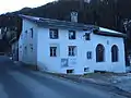
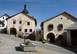 Fountain in the village of Tschlin | |
 Coat of arms | |
Location of Valsot 
| |
 Valsot Valsot | |
| Coordinates: 46°52′N 10°25′E | |
| Country | Switzerland |
| Canton | Graubünden |
| District | Engiadina Bassa/Val Müstair |
| Area | |
| • Total | 158.96 km2 (61.37 sq mi) |
| Population (2018-12-31)[2] | |
| • Total | 854 |
| • Density | 5.4/km2 (14/sq mi) |
| Time zone | UTC+01:00 (Central European Time) |
| • Summer (DST) | UTC+02:00 (Central European Summer Time) |
| Postal code(s) | 7556, 7559 |
| SFOS number | 3764 |
| Localities | Martina (includes Vinadi), Seraplana, Strada (includes Chaflur) and Tschlin |
| Surrounded by | Graun im Vinschgau (IT-BZ), Nauders (AT-7), Pfunds (AT-7), Samnaun, Spiss (AT-7) |
| Website | http://www.valsot.ch SFSO statistics |
History
Ramosch
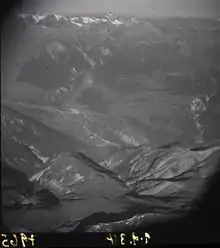
In 1956-58, on the hill Mottata (ca. 1.5 kilometers (0.93 mi) north-east of Ramosch), a significant prehistoric site was discovered. The Mottata site contains three settlement horizons, two from the mid and early Bronze Age (Laugen-Melaun/Luco-Meluno culture) and one from the early Iron Age (Fritzens-Sanzeno culture).[4]
Tschlin
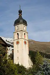
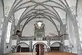
While Bronze and Iron Age items have been found in Tschlin, the first mention of the village is in the 10th Century. In the 10th Century, bishop Hildibald gave the chapterhouse in Chur a gift of a farm house in Tschlin. In the High Middle Ages Tschlin was under the authority of Ramosch. The village church of St. Blasius was built in 1515 in the gothic style. In 1545 the Protestant Reformation reached the village and in 1574-82 the reformer and historian Ulrich Campell worked in Tschlin. In 1856 a fire destroyed much of the village, including the Church of St. John the Baptist. The church was not rebuilt, but the church tower is still visible in the village.[5]
Geography
Valsot has an area of 158.96 km2 (61.37 sq mi).
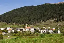
Ramosch had an area, as of 2006, of 84.1 km2 (32.5 sq mi). Of this area, 32.7% is used for agricultural purposes, while 26.5% is forested. Of the rest of the land, 0.7% is settled (buildings or roads) and the remainder (40.1%) is non-productive (rivers, glaciers or mountains).[6] It is along the left bank of the Inn river. It consists of the village of Ramosch and the village section of Vnà as well as the settlements of Raschvella and Seraplana. Until 1943 Ramosch was known as Remüs.[3]
Tschlin had an area, as of 2006, of 75.1 km2 (29.0 sq mi). Of this area, 28.7% is used for agricultural purposes, while 34.7% is forested. Of the rest of the land, 1.3% is settled (buildings or roads) and the remainder (35.3%) is non-productive (rivers, glaciers or mountains).[6] It consists of the village of Tschlin on a terrace above the left bank of the Inn, the sections of Strada and Martina and the hamlets of San Niclà, Chaflur, Sclamischot and Vinadi. Until 1943 Tschlin was known as Schleins.[3]
Demographics
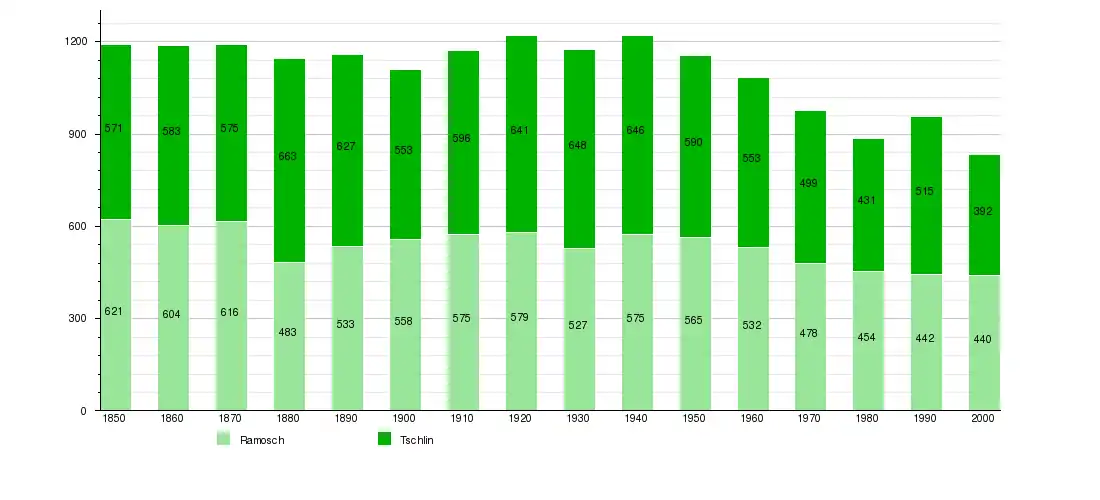
Valsot has a combined population (as of 31 December 2019) of 841.[7]
Languages
Most of the population in Ramosch (as of 2000) speaks Romansh (84.1%), with German being second most common (13.9%) and Dutch being third (1.1%).[6]
Ramosch
| Languages in Ramosch | ||||||
| Languages | Census 1980 | Census 1990 | Census 2000 | |||
| Number | Percent | Number | Percent | Number | Percent | |
| German | 44 | 9.69% | 59 | 13.35% | 61 | 13.86% |
| Romansh | 399 | 87.89% | 363 | 82.13% | 370 | 84.09% |
| Italian | 9 | 1.98% | 15 | 3.39% | 2 | 0.45% |
| Population | 454 | 100% | 442 | 100% | 440 | 100% |
Tschlin
Most of the population of Tschlin (as of 2000) speaks Romansh (71.4%), with German being second most common (25.5%) and Serbo-Croatian being third (1.0%).[6]
| Languages in Tschlin | ||||||
| Languages | Census 1980 | Census 1990 | Census 2000 | |||
| Number | Percent | Number | Percent | Number | Percent | |
| German | 64 | 14.85% | 130 | 25.24% | 100 | 25.51% |
| Romansh | 362 | 83.99% | 313 | 60.78% | 280 | 71.43% |
| Italian | 4 | 0.93% | 33 | 6.41% | 3 | 0.77% |
| Population | 431 | 100% | 515 | 100% | 392 | 100% |
Heritage sites of national significance
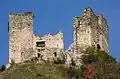
Tschanüff Castle, the Mottata (a prehistoric settlement) and the Swiss Reformed Church of St. Florinus in Ramosch and the Museum Stamparia da Strada in Tschlin are listed as Swiss heritage sites of national significance.[9]

References
- "Arealstatistik Standard - Gemeinden nach 4 Hauptbereichen". Federal Statistical Office. Retrieved 13 January 2019.
- "Ständige Wohnbevölkerung nach Staatsangehörigkeitskategorie Geschlecht und Gemeinde; Provisorische Jahresergebnisse; 2018". Federal Statistical Office. 9 April 2019. Retrieved 11 April 2019.
- Amtliches Gemeindeverzeichnis der Schweiz published by the Swiss Federal Statistical Office (in German) accessed 2 January 2013
- Ramosch in German, French and Italian in the online Historical Dictionary of Switzerland.
- Tschlin in German, French and Italian in the online Historical Dictionary of Switzerland.
- Swiss Federal Statistical Office accessed 12-Oct-2009
- "Ständige und nichtständige Wohnbevölkerung nach institutionellen Gliederungen, Geburtsort und Staatsangehörigkeit". bfs.admin.ch (in German). Swiss Federal Statistical Office - STAT-TAB. 31 December 2019. Retrieved 6 October 2020.
- Federal Statistical Office STAT-TAB Bevölkerungsentwicklung nach Region, 1850-2000 Archived 2012-03-17 at the Wayback Machine (in German) accessed 29 January 2011
- Swiss inventory of cultural property of national and regional significance Archived 2009-05-01 at the Wayback Machine 21.11.2008 version, (in German) accessed 12-Oct-2009
| Wikimedia Commons has media related to Valsot. |