Van Nuys station (Los Angeles Metro)
Van Nuys is a station on the bus rapid transit G Line, in the Los Angeles County Metropolitan Transportation Authority's Metro Busway system. It is named after adjacent Van Nuys Boulevard, which travels north-south and crosses the east-west busway route and is located in the Van Nuys district of Los Angeles, in the San Fernando Valley.[1] Adjacent to the station is the G Line's bicycle path.
Van Nuys | ||||||||||||||||||||||||||
|---|---|---|---|---|---|---|---|---|---|---|---|---|---|---|---|---|---|---|---|---|---|---|---|---|---|---|
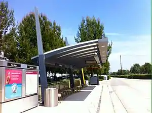 Platform View | ||||||||||||||||||||||||||
| Location | 6060-6062 Van Nuys Blvd, Los Angeles, California, U.S. | |||||||||||||||||||||||||
| Coordinates | 34.1805°N 118.4487°W | |||||||||||||||||||||||||
| Elevation | at-grade | |||||||||||||||||||||||||
| Owned by | Metro | |||||||||||||||||||||||||
| Line(s) | ||||||||||||||||||||||||||
| Platforms | 2 side | |||||||||||||||||||||||||
| Tracks | 2 | |||||||||||||||||||||||||
| Construction | ||||||||||||||||||||||||||
| Parking | 776 spaces | |||||||||||||||||||||||||
| Bicycle facilities | 12 bike rack spaces 8 bike lockers | |||||||||||||||||||||||||
| Disabled access | Yes | |||||||||||||||||||||||||
| Other information | ||||||||||||||||||||||||||
| Status | in service | |||||||||||||||||||||||||
| History | ||||||||||||||||||||||||||
| Opened | October 29, 2005 | |||||||||||||||||||||||||
| Rebuilt | 2024 (planned) | |||||||||||||||||||||||||
| Services | ||||||||||||||||||||||||||
| ||||||||||||||||||||||||||
| ||||||||||||||||||||||||||
| Location | ||||||||||||||||||||||||||

| ||||||||||||||||||||||||||
The platform features a painting by Roxene Rockwell called The New Town, which shows an example of the wheat and sugar beet fields that marked the area before it was developed.[2]
Service
Station Layout
| Eastbound | ■ G Line | toward Chatsworth (Sepulveda) |
| Westbound | ■ G Line | toward North Hollywood (Woodman) |
Bus connections
- Metro Local: 154, 233, 237
- Metro Rapid: 744, 788
- LADOT DASH: Van Nuys/Studio City
History
.jpg.webp)
The rail line through the San Fernando Valley was established by the Southern Pacific in 1893. When the Montalvo Cutoff was constructed in 1904, most traffic was diverted over a new mainline which ran diagonally across the valley and the tracks were relegated to branch status.[5] Pacific Electric interurban trains reached Van Nuys by December 1911,[6] crossing the Southern Pacific tracks at Van Nuys Boulevard.[7]
The Orange Line (now the G Line) began operations over the former Burbank branch with new facilities to serve rapid buses on October 29, 2005.
Future development
As part of the Orange Line Service Improvements Project, which aims to increase bus speeds and capacity through the corridor, the station is planned to be rebuilt on a grade-separated bridge to decrease interference from traffic.[8]
Van Nuys station will serve as the southern terminus of the East San Fernando Light Rail Project light rail line in 2028.[9] In June 2018, Metro staff recommended light rail as the preferred transport mode along this route. This route will connect to Amtrak and Metrolink's Van Nuys train station and Sylmar/San Fernando Metrolink station to the north. Additionally, the Sepulveda Pass Transit Corridor service may connect to the station.
References
- "Orange Line station information". Retrieved 2010-10-02.
- "Van Nuys, The New Town by Roxene Rockwell".
- "Metro G Line Timetable" (PDF). Los Angeles County Metropolitan Transportation Authority. June 24, 2018. Retrieved June 25, 2018.
- "Orange Line timetable" (PDF). Retrieved 2010-10-02.
- Curtiss, Aaron (7 April 1996). "Tracks to the Past". Los Angeles Times. Retrieved 31 January 2021.
- Veysey, Laurence R. (June 1958). A History Of The Rail Passenger Service Operated By The Pacific Electric Railway Company Since 1911 And By Its Successors Since 1953 (PDF). LACMTA (Report). Retrieved 19 September 2020.
- Van Nuys (Map). United States Geological Survey. 1924. Retrieved 31 January 2021.
- Metro Orange Line Grade Separation Analysis and Operational Improvements Technical Study Task 10.0 Executive Summary FINAL version 5.0 (PDF). Metro (Report). Iteris, STV, TransLink, and WSP. Retrieved 29 August 2020.
- "Public comment begins on L.A. Metro's FEIS/R for LRT project between Van Nuys and San Fernando". Mass Transit. Los Angeles County Metropolitan Transportation Authority. 5 October 2020. Retrieved 19 October 2020. Cite magazine requires
|magazine=(help)
External links
- LA Metro: Orange Line Timetable - schedules
- LA Metro: Orange Line map and stations - route map and station addresses and features
- Orange Line history
- LA Metro - countywide: official website