Sepulveda Pass Transit Corridor
The Sepulveda Pass Transit Corridor is a two-phased planned heavy rail transit corridor connecting the Los Angeles Basin to the San Fernando Valley through the Sepulveda Pass in Los Angeles, California, by supplementing the existing freeway. The corridor would partly parallel I-405, and proposed alternatives include heavy rail subway and monorail connecting the G Line in the Valley to the D Line and E Line on the Westside, and the Crenshaw/LAX Line near Los Angeles International Airport.[1]
| Overview | |||||||||||||||||||||||||||||||||||||||||||||||||||||||||||||||||||||||||||||||||||||||||||||||||||||||||||||||||||||||||||||||||||||||||||||||||||||||||||||||||||||||||||||||||||||||||||||||||||||||||||||||||||||||||||||||||||||||||||||||||||||||||||||||||||||||||||||||||||||||||||||||||||||||||||||||||||||||||||||||||||||||||||||||||||||||||||||||||||||||||||||||||||||||||||||||||||||||||||
|---|---|---|---|---|---|---|---|---|---|---|---|---|---|---|---|---|---|---|---|---|---|---|---|---|---|---|---|---|---|---|---|---|---|---|---|---|---|---|---|---|---|---|---|---|---|---|---|---|---|---|---|---|---|---|---|---|---|---|---|---|---|---|---|---|---|---|---|---|---|---|---|---|---|---|---|---|---|---|---|---|---|---|---|---|---|---|---|---|---|---|---|---|---|---|---|---|---|---|---|---|---|---|---|---|---|---|---|---|---|---|---|---|---|---|---|---|---|---|---|---|---|---|---|---|---|---|---|---|---|---|---|---|---|---|---|---|---|---|---|---|---|---|---|---|---|---|---|---|---|---|---|---|---|---|---|---|---|---|---|---|---|---|---|---|---|---|---|---|---|---|---|---|---|---|---|---|---|---|---|---|---|---|---|---|---|---|---|---|---|---|---|---|---|---|---|---|---|---|---|---|---|---|---|---|---|---|---|---|---|---|---|---|---|---|---|---|---|---|---|---|---|---|---|---|---|---|---|---|---|---|---|---|---|---|---|---|---|---|---|---|---|---|---|---|---|---|---|---|---|---|---|---|---|---|---|---|---|---|---|---|---|---|---|---|---|---|---|---|---|---|---|---|---|---|---|---|---|---|---|---|---|---|---|---|---|---|---|---|---|---|---|---|---|---|---|---|---|---|---|---|---|---|---|---|---|---|---|---|---|---|---|---|---|---|---|---|---|---|---|---|---|---|---|---|---|---|---|---|---|---|---|---|---|---|---|---|---|---|---|---|---|---|---|---|---|---|---|---|---|---|---|---|---|---|---|---|---|---|---|---|---|---|---|---|---|---|---|---|---|---|---|---|---|---|---|---|---|---|---|---|---|---|---|---|---|---|---|---|---|---|---|---|---|---|---|
| Status | Planned | ||||||||||||||||||||||||||||||||||||||||||||||||||||||||||||||||||||||||||||||||||||||||||||||||||||||||||||||||||||||||||||||||||||||||||||||||||||||||||||||||||||||||||||||||||||||||||||||||||||||||||||||||||||||||||||||||||||||||||||||||||||||||||||||||||||||||||||||||||||||||||||||||||||||||||||||||||||||||||||||||||||||||||||||||||||||||||||||||||||||||||||||||||||||||||||||||||||||||||
| Locale | San Fernando Valley Westside | ||||||||||||||||||||||||||||||||||||||||||||||||||||||||||||||||||||||||||||||||||||||||||||||||||||||||||||||||||||||||||||||||||||||||||||||||||||||||||||||||||||||||||||||||||||||||||||||||||||||||||||||||||||||||||||||||||||||||||||||||||||||||||||||||||||||||||||||||||||||||||||||||||||||||||||||||||||||||||||||||||||||||||||||||||||||||||||||||||||||||||||||||||||||||||||||||||||||||||
| Service | |||||||||||||||||||||||||||||||||||||||||||||||||||||||||||||||||||||||||||||||||||||||||||||||||||||||||||||||||||||||||||||||||||||||||||||||||||||||||||||||||||||||||||||||||||||||||||||||||||||||||||||||||||||||||||||||||||||||||||||||||||||||||||||||||||||||||||||||||||||||||||||||||||||||||||||||||||||||||||||||||||||||||||||||||||||||||||||||||||||||||||||||||||||||||||||||||||||||||||
| Type | Heavy rail or Monorail | ||||||||||||||||||||||||||||||||||||||||||||||||||||||||||||||||||||||||||||||||||||||||||||||||||||||||||||||||||||||||||||||||||||||||||||||||||||||||||||||||||||||||||||||||||||||||||||||||||||||||||||||||||||||||||||||||||||||||||||||||||||||||||||||||||||||||||||||||||||||||||||||||||||||||||||||||||||||||||||||||||||||||||||||||||||||||||||||||||||||||||||||||||||||||||||||||||||||||||
| System | Metro | ||||||||||||||||||||||||||||||||||||||||||||||||||||||||||||||||||||||||||||||||||||||||||||||||||||||||||||||||||||||||||||||||||||||||||||||||||||||||||||||||||||||||||||||||||||||||||||||||||||||||||||||||||||||||||||||||||||||||||||||||||||||||||||||||||||||||||||||||||||||||||||||||||||||||||||||||||||||||||||||||||||||||||||||||||||||||||||||||||||||||||||||||||||||||||||||||||||||||||
| |||||||||||||||||||||||||||||||||||||||||||||||||||||||||||||||||||||||||||||||||||||||||||||||||||||||||||||||||||||||||||||||||||||||||||||||||||||||||||||||||||||||||||||||||||||||||||||||||||||||||||||||||||||||||||||||||||||||||||||||||||||||||||||||||||||||||||||||||||||||||||||||||||||||||||||||||||||||||||||||||||||||||||||||||||||||||||||||||||||||||||||||||||||||||||||||||||||||||||
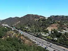
The Sepulveda Pass Interstate 405 commute between Interstate 10 and US Highway 101 lies along the busiest highway corridor in the United States, serving 379,000 vehicles per day.[2] The most popular idea has been a rail transit tunnel, as the rugged terrain of the pass makes surface and elevated alternatives almost equally expensive.[3]
Overview
The line was portrayed in the project map included in the 1980 Proposition A documentation.
The Los Angeles County Metropolitan Transportation Authority (Metro) has $10 billion in funds available for construction planned to begin in 2026.[4] The plan included in the Measure M transportation funding measure is to build improvements in three stages: additional lanes to be used for express bus service to open by 2028, an 8.8-mile (14.2 km) transit project between the Orange Line’s Van Nuys Station and the Purple Line Extension’s Wilshire/Westwood Station by 2035, and a planned extension to LAX with a 2059 completion date.[5][6] In April 2017, Metro issued a Request for Proposals to study alternatives, and several companies sent unsolicited proposals to accelerate the project via public-private partnerships.[7] The project's timeline is expected to be accelerated under the Twenty-eight by '28 initiative.[8] The Metro Board of Directors in late 2019 will decide which concept routes to start the project's formal environmental studies.[9]
Proposed routings and modes
In June 2018, Metro released its initial six alternative rail concepts for the corridor. All of the proposals provided connections between the G Line (at Sepulveda, Van Nuys, or both) and the E Line (at Expo/Sepulveda or Expo/Bundy), as well as to the Westside extension of the D Line, currently under construction, and to the East San Fernando Valley Transit Corridor, currently being planned. The proposals fell into four categories:
- A standalone heavy rail line, mostly underground but possibly with some elevated sections in the Valley.
- A continuation of the East San Fernando Valley Transit Corridor light rail, mostly underground but with a possible elevated spur to Sepulveda station.
- A monorail or rubber-tired metro line, underground on the Westside, elevated in the Valley, and running at grade or elevated along the 405.
- An further extension of the heavy rail D Line, with a wye that would allow direct connections between the Valley and the E Line as well as from both to downtown. This option would be mostly underground but could include elevated sections in the Valley.[10]
In January 2019, Metro released a refined second set of rail concepts for the corridor, eliminating light rail and rubber-tired metro technology from consideration and narrowing it down to four concepts:[4]
- Three routings for a heavy rail line, mostly underground but possibly with some elevated sections in the Valley.
- A monorail, underground on the Westside, elevated in the Valley along Sepulveda Blvd, and running at grade or elevated along the 405, terminating at the Van Nuys Metrolink station.
In July 2019, Metro released a third refined rail concept after community input.
- Mostly the same routes, per metro feedback, they added a Santa Monica Boulevard Station.
- Cost increase, ridership projection increases.
The feasibility study for both phases was completed and presented in November 2019,[11] with no major refinement from the July 2019 presentation. Per study, additional research is needed on identifying relocation or maneuvering around a nine foot wide DWP water pipe, called the "Sepulveda Feeder".[12] Additional studies on general station locations, tunnel design configuration, rider transfer patterns and identifying cost and cost reductions. Also, the study wants information on the impact of the known Santa Monica Fault near Santa Monica Boulevard. The Metro Board will commence the NEPA and CEQA scoping process.
Initial alternatives analysis
Phase One: Valley–Westside
The January 2019 updated concepts released by Metro for phase one included four alternative plans to be considered. These included different alignments, but only two modes of transit: heavy rail or monorail. The new alternatives considered in the Draft Environmental Impact Report[13] north to south routes from the Valley to E Line are:
| DEIR Alternative[4] | Description | Ridership (daily) |
Estimated cost (billions) |
|---|---|---|---|
| Alternative 1: HRT Van Nuys Boulevard[14] | A heavy rail transit (HRT) line heading south from the Van Nuys Metrolink station under Van Nuys Blvd with stops at the current Van Nuys Orange Line station and a new stop at Ventura Boulevard, then leaving the San Fernando Valley and heading south under the Santa Monica Mountains with stops within the UCLA campus and a transfer stop on the Purple Line extension Westwood/UCLA station. A station on Santa Monica Boulevard before terminating at the E Line, at either Expo/Sepulveda station or Expo/Bundy Station. A 16-minute ride. | 128,000 [15] | $10.6 to $13.5 [15] |
| Alternative 2: HRT SW to Sepulveda Boulevard [4] | An HRT line heading southwest from the Van Nuys Metrolink station underground to the Orange Line's Sepulveda station, then continuing under Sepulveda Boulevard to Ventura Boulevard and then heading under the Santa Monica Mountains to West LA; follows a route similar to Alternative 1 on the westside. A 17-minute ride. | 126,000 | $11.0 to $13.8 |
| Alternative 3: HRT Aerial Sepulveda Boulevard[14] | An HRT line similar to Alternative 2 in alignment, but with an aerial alignment in the Valley and a potential new stop at Sepulveda and Sherman Way. A 19-minute ride. | 137,000 | $9.9 to $12.2 |
| Alternative 4: MRT Aerial Sepulveda Boulevard[14] | A monorail line similar to Alternative 3 in alignment and station placement, but with much of the route over the Santa Monica mountains in an aerial structure or at grade along the 405. A 26-minute ride. | 122,000 | $9.4 to $11.6 |
The following table shows all potential metro stations, and the alternatives for which they apply:
| Station Options[1] | Alt 1 | Alt 2 | Alt 3 | Alt 4 | Connecting rail services[16] |
Community |
|---|---|---|---|---|---|---|
| Van Nuys | × | × | × | × | Future station of the East San Fernando Valley LRT. |
Van Nuys |
| Sepulveda Boulevard\Sherman Way | - | - | × | × | Van Nuys | |
| Van Nuys | × | - | - | - | Future southern terminus station of the East San Fernando Valley LRT. |
Van Nuys |
| Sepulveda | - | × | × | × | Van Nuys | |
| Ventura Boulevard/Van Nuys Boulevard | × | - | - | - | Sherman Oaks | |
| Ventura Boulevard/Sepulveda Boulevard | - | × | × | × | Sherman Oaks | |
| UCLA | × | × | × | × | Westwood | |
| Westwood/UCLA | × | × | × | × | Westwood | |
| Santa Monica Boulevard | × | × | × | × | West Los Angeles | |
| Expo/Sepulveda or Expo/Bundy | × | × | × | × | West Los Angeles | |
- MSF Locations
Three Maintenance and Storage Facility (MSF) options are being proposed.[15]
- Sepulveda at Nebraska (all alternatives).
- Van Nuys at Arminta (HRT 1 and HRT 2).
- Woodman at Van Nuys Metrolink Station (HRT 3 and MRT 1).
Phase Two: Westside–LAX
Early concepts for phase two from E Line to LAX/Crenshaw Line were released in 2019, with detailed connections to the under-construction LAX Automated People Mover.[1] Metro hopes to complete the feasibility study by 2019 and begin an environmental impact review along with phase one.
There are two main modes for phase two of the corridor. There are five proposed concepts that begin at either Expo/Bundy station or Expo/Sepulveda station, contingent on the terminus of the first phase of the project. All routes terminate at the Aviation/96th Street station, which is currently under construction as part of the Crenshaw/LAX Transit Corridor Project. This terminus station will offer transfers to the Crenshaw/LAX line, and LAX Automated People Mover.[4]
Concepts include routing south along Sepulveda Boulevard, Overland Boulevard, Centinela Boulevard and Interstate 405, with possible intermediate stops at Venice Boulevard, Culver City Transit Center, the Howard Hughes Center, and Sepulveda Boulevard at Manchester Boulevard. The Sepulveda Boulevard route option would be completed as below-grade heavy rail, while the I-405 option could be completed as either a combination of elevated and below-grade heavy rail, or a combination of elevated and below-grade monorail.[17]
The July 2019 updated concepts released by Metro for phase two added a stop along Santa Monica Boulevard per public popular demand. They added the fifth concept, extending the east/west purple line extension terminus south towards LAX. A one-boarding HRT trip from LAX to Downtown Los Angeles along Centinela Blvd.[13]
All north to south routes from the E Line to LAX are:
| DEIR Alternative[4] | Description | Ridership (daily) |
Estimated cost (billions) |
|---|---|---|---|
| Alternative 1: HRT or MRT I-405 route[14] | A heavy rail transit (HRT) line heading south from the Expo/Sepulveda station on the I-405 median with an aerial stop at Venice Blvd/I-405. Leaves the aerial route and continues underground with stations on Centinela/Sepulveda and Manchester/Sepulveda near LAX. The southern terminus station is at Aviation/96th Street station at LAX.[15] A 38-minute ride. | MRT: 173,000 HRT: 228,000[15] | |
| Alternative 2: Centinela route[14] | A heavy rail transit (HRT) line heading south underground from either Expo/Bundy station or Expo/Sepulveda station with stops at Venice/Centinela, Culver/Centinela, Jefferson/Centinela, and Manchester/Sepulveda with its southern terminus station at Aviation/96th Street station near LAX.[15] A 31-minute ride. | 229,000[15] | |
| Alternative 3: HRT Sepulveda route[14] | A heavy rail transit (HRT) line heading south underground from the Expo/Sepulveda station along Sepulveda Boulevard with stops at Venice/Sepulveda, Jefferson/Sepulveda and Manchester/Sepulveda near LAX. The southern terminus station is at Aviation/96th Street station at LAX.[15] A 30-minute ride. | 236,000[15] | |
| Alternative 4: HRT Overland Avenue route[14] | A heavy rail transit (HRT) line heading south underground from the Expo/Sepulveda station to Overland Avenue. Stations located on Overland/Venice Blvd. and Overland/Jefferson Blvd, Jefferson/Sepulveda and Manchester/Sepulveda near LAX. The southern terminus station is at Aviation/96th Street station at LAX.[15] A 31-minute ride. | 233,000[15] | |
| Alternative 5: D Line Extension routes[14] | A heavy rail transit (HRT) extension south of the under construction D Line extension terminus station of Westwood/VA Hospital station or Westwood/UCLA station, a stop on Santa Monica Boulevard and then follow the Centinela Ave route alternative (alt 2) as underground HRT. The southern terminus station is at Aviation/96th Street station at LAX.[15] A 31-minute ride. | 275,000[15] |
The following table shows all potential metro stations, and the alternatives for which they apply:
| Station Options[1] | Alt:1 | Alt:2 | Alt:3 | Alt:4 | Alt:5 | Connecting rail services[18] |
Community |
|---|---|---|---|---|---|---|---|
| Westwood/UCLA or Westwood/VA Hospital (Under Construction as HRT) | - | - | - | - | × | Westwood | |
| Expo/Bundy or Expo/Sepulveda (Already Built as LRT) | × | × | × | × | × | West Los Angeles | |
| Venice Boulevard | × | × | × | × | × | Mar Vista | |
| Culver Boulevard | - | × | - | - | - | Del Rey/Culver West | |
| Jefferson Boulevard | × | × | × | × | × | Playa Vista/Fox Hills | |
| Manchester Boulevard/Sepulveda | × | × | × | × | × | Westchester | |
| Aviation/96th Street Station (Under Construction as LRT) | × | × | × | × | × | LAX Automated People Mover (by 2023) |
Westchester |
Alternative 5 concept for the Westside-LAX phase of the Sepulveda Transit Corridor would extend the Purple Line subway south down Centinela Ave along the same route as the other proposed Centinela Ave concepts (Alt 2). This concept would provide a one-seat ride from the LAX Automated People Mover to Downtown Los Angeles, but would require passengers from the San Fernando Valley to transfer at Westwood/UCLA station to travel further south.[17]
The second phase of the Sepulveda Transit Corridor is not due to break ground until 2048.
Advocacy
Transit advocates have proposed combining the Van Nuys Transit Corridor and Sepulveda Pass Corridor into a single study with an aim to connect Sylmar, Van Nuys, the Orange Line, Sherman Oaks, UCLA, and the future Westwood/UCLA Purple Line station. Metro studies declined the LRT merge option and stated HRT would provide faster times and more occupancy on trains. Future extension phases south to the E Line, LAX, South Bay, or beyond are also being advocated and proposed.[19] Metro proposed a Centinela Avenue route to LAX or thru Sepulveda Boulevard. No studies have been allocated funds.
Phase one of the project is part of Metro's Twenty Eight by '28 initiative, which aims to complete its list of expansions in time for the 2028 Summer Olympics.[1] Metro is looking into a public/private partnership to accelerate the opening.
Construction
Measure R and Measure M timelines call for construction to begin in 2043, though the first phase may be accelerated in preparation for the 2028 Summer Olympics.
References
- "Rail concepts released for Sepulveda Transit Corridor project". Metro.
- "I-405 In LA Named Busiest Interstate In Any U.S. City". CBS Los Angeles. CBS Broadcasting Inc. Retrieved 7 July 2017.
- Los Angeles Magazine
- "Here are the four new refined concepts for Sepulveda Transit Corridor". Metro. 29 January 2019. Retrieved 19 August 2020.
- Hymon, Steve. "Of monorails, Measure M and the Sepulveda Pass; How We Roll, June 14". LACMTA. Retrieved July 1, 2017.
- "Metro Seeks Mass Transit Solution For Sepulveda Pass". CBS Los Angeles. CBS Broadcasting. Retrieved 1 August 2017.
- Sotero, Dave. "Metro releases RFP to study Sepulveda Pass transit options". LACMTA. Retrieved July 1, 2017.
- Sharp, Steven (27 November 2018). "Here are the 28 Projects that Metro Could Complete Before the 2028 Olympics". Urbanize. Retrieved 2 July 2018.
- https://thesource.metro.net/2019/07/23/more-refined-concepts-and-cost-estimates-are-released-for-sepulveda-transit-corridor/
- Grigoryants, Olga. "LA Metro releases concepts for a rail line through, over, or under the Sepulveda Pass. Take your pick". Los Angeles Daily News. Retrieved 2 July 2018.
- http://media.metro.net/projects_studies/sfv-405/images/Feasibility%20Report.pdf
- https://www.clui.org/newsletter/summer-1997/metropolitan-water-districts-sepulveda-canyon-facility
- https://thesource.metro.net/wp-content/uploads/2019/01/Refined-Concepts.jpg
- Next stop: exploring alternatives to the 405 (Report). Metro. June 2018. Retrieved 19 August 2019.
- Next stop: exploring alternatives to the 405 (Report). Metro. July 2019. Retrieved 19 August 2019.
- "Bus and Rail System Map" (PDF). Los Angeles County Metropolitan Transportation Authority. Retrieved 2018-12-03.
- https://media.metro.net/projects_studies/sfv-405/images/presentation_Sepulveda_HNTB_2019-01.pdf
- "Bus and Rail System Map" (PDF). Los Angeles County Metropolitan Transportation Authority. Retrieved 2018-12-03.
- Reed, Bart. "Valley-Westside Rail Tunnel". The Transit Coalition. Retrieved April 12, 2011.
External links
| Services |
|  | ||||||||||||
|---|---|---|---|---|---|---|---|---|---|---|---|---|---|---|
| Stations | ||||||||||||||
| Facilities | ||||||||||||||
| Capital projects |
| |||||||||||||
| Fleet | ||||||||||||||
| Other information | ||||||||||||||