Vellarada
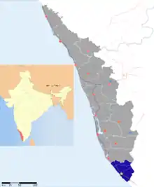
Vellarada is a border village situated in Thiruvananthapuram district in the state of Kerala, India.[1] It is 42 km from Thiruvananthapuram. It is the southernmost part of Kerala state, sharing its border with Tamil Nadu. Vellarada is said to be the threshold to the high-range areas of the eastern part of Thiruvananthapuram district. The southernmost point of Western Ghats in Kerala is near Vellarada.
Vellarada | |
|---|---|
village | |
 Vellarada Location in Kerala, India  Vellarada Vellarada (India) | |
| Coordinates: 8.4444°N 77.2016°E | |
| Country | India |
| State | Kerala |
| District | Thiruvananthapuram |
| Government | |
| • Body | Grama Panchayath |
| Population (2001) | |
| • Total | 31,384 |
| Languages | |
| • Official | Malayalam, English |
| Time zone | UTC+5:30 (IST) |
| PIN | 695505 |
| Vehicle registration | KL-19 |
Vellarada is also known for its hilltop shrine "Kurisumala Pilgrim Centre[2]" (also called Thekkan kurisumala) which is located at a height of 3,000 feet. Thousands of devotees from various parts of Tamil Nadu, Kerala, Andhra Pradesh and Karnataka visit the shrine during Lent every year.
Demographics
As of 2011 India census, A total of 8285 families resides in Vellarada. Vellarada village had a population of 31839 with 15702 males and 16137 females. There is a positive sex ratio of 1027 existing in Vellarada. Literacy is at 87.78 %. The dominant religions in Vellarada are Hinduism and Christianity. The Scheduled Caste (SC) constitutes 5.82 % while Schedule Tribe (ST) was 0.78 % of the total population in Vellarada village.
Majority of the population practice agriculture, chiefly cash crops like rubber.
Administration
- From local self-government perspective, in the three-tier Panchayati Raj local self-government model, Vellarada Grama Panchayat falls in the Perumkadavila Block Panchayat of Thiruvananthapuram Jilla PanchayatPanchayath. The Vellarada Grama Panchayat , in turn, has 23 wards which are the smallest administrative unit.
- In the political map of the country, Vellarada falls into Parassala Legislative assembly constituency of Kerala state and Thiruvananthapuram (Lok Sabha constituency) of parliament of India.
- In revenue administration point of view Vellarada Village falls into Neyyattinkara taluk of Thiruvananthapuram district.
- In Law and Order perspective, Vellarada falls under Kerala Police's Thiruvananthapuram Rural police district. The station serves neighbouring villages of Kunnathukal and Amboori also.
- In terms of registration, Vellarada has a Sub Registrar Office, that is under Department of Registration, Government of Kerala. However, Vellarada SRO doesn't have an independent vehicle registration code Parassala (KL -19).
Transportation
In the case of transportation Vellarada doesn't have direct rail connectivity or waterways connectivity. Roadways are the main and only mode of transportation.
Roadways
The major roads passing through Vellarada are,
- The Hill Highway (Kerala) from Parassala to Nandarapadavu in Kasaragod,
- The State Highway 3 (Kerala) i.e. The Nedumangad–Aralvaimozhi road made by Travancore kings that pass through Anappara in Vellarada and,
Public transport through road is entirely managed by KSRTC and TNSTC.
- Kerala State Road Transport Corporation connects Vellarada directly with district headquarters Thiruvananthapuram, Neyyattinkara, Parassala, Kattakada, Nedumangad and distant towns such as Kottayam, Erattupetta and Kottarakkara. There are no private buses operating through Vellarada.
- TNSTC has only a very few services through Vellarada.TNSTC connects Vellarada directly with Kanyakumari, Thakkala, Nagercovil most of them connect to either Parassala or Marthandam. TNSTC is available in abundance from a nearby place called Panachamoodu which is a town that's partially in Kerala and partially in Tamil Nadu.
Railways
The nearest railway stations from Vellarada are,
Parassala railway station - 13 km
Dhanuvachapuram railway station - 15 km
Neyyattinkara railway station - 17 km
Thiruvananthapuram Central railway station - 37 km
Eraniel railway station - 37 km
Airways
The nearest airports are,
Trivandrum International Airport - 40 km
Tuticorin Airport - 151 km
Cochin International Airport - 260 km
Tourist Attractions
- Thekkan Kurissumala
- Kurissumala Sangamavedi
- Chittar Dam and reservoir (in Tamil Nadu)
- Neyyar Wild Life Sanctuary
- Neyyar Dam
- Kottur Elephant Rehabilitation Center
- Mayam Kadavu, Amboori.
Health Care
- Vellarada Community Health Centre
- Ruckmony Hospital
- CSI Medical College Karakonam
Educational institutions
- Velayudha panikkar memorial higher secondary school vellarada
- Seventh Day School
- Govt Ups Vellarada
- Easwara Vilasam Up School Koothali
- Govt Lps School Koothali
- Lms Lps Anchumaramkala
- LMS LPS Manoor, Pattamthalakkal
Higher Education Institutes
- CSI Medical College, Karakonam
- PRS Engineering College, Paliyode
- UIT Arattukuzhi
Religious
- Thekkan Kurisumala pilgrim center
- St pius church Kurisumala
- Kalimala
- Choondical Sree Bhadrakali Devi Temple
- Kaliyikkal Sree Bhadrakaali Temple
- Pachayam Sree Dharma shastha Temple
- Chirathalakkal Sree Bhagavathy Temple
- C S I Churuli
- C S I Manali
- C S I vellarada(district&Area Church)
- C S I muttachal
- vencodu Sree Dharmasastha Temple
References
- "Census of India : Villages with population 5000 & above". Registrar General & Census Commissioner, India. Retrieved 10 December 2008.
- "Kurisumala pilgrimage to begin on March 13". The Hindu. 8 March 2013. ISSN 0971-751X. Retrieved 22 October 2015.
- "Karamana-Vellarada road to be developed in two phases". The Hindu. Special Correspondent. 13 June 2019. ISSN 0971-751X. Retrieved 6 April 2020.CS1 maint: others (link)
