Hill Highway (Kerala)
The Hill Highway or Malayora Highway or State Highway 59 (SH-59) is the longest state highway in Kerala. The proposed highway extends from Nandarapadavu in Kasaragod district to Vithura Parassala in Thiruvananthapuram district, will have a length of 1332.16 km. The expected outlay for the project is Rs.1,500 crore. The proposed highway would pass through areas including Bandadka, Malom, Chittarikkal, Cherupuzha, Alakode, Payyavoor, Ulikkal, Mananthavady, Kalpetta, Thiruvambady, Edakkara, Palakkad, Pattikkad, Neriamangalam, Kattappana, Mundakayam, Erumely, Ranni, Konni, Koodal, Vazhathope, Pathanapuram, Punalur, Anchal, Kulathupuzha, Madathara, Palode, Vithura,Aryanadu,Vellarada This highway will pass through 13 out of the 14 districts of Kerala state. Alappuzha is not connected by this highway as that district is not part of the hilly ranges of Kerala. Between Kannur and Malappuram districts, this highway will have two parallel routes, one through Wayanad district and another through Kozhikode district.[1]
| |
|---|---|
| Hill Highway | |
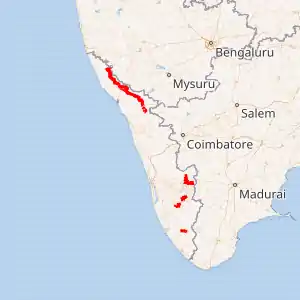
Map of the State Highway in red | |
| Route information | |
| Maintained by Kerala Public Works Department | |
| Length | 1,332.16 km (827.77 mi) |
| Major junctions | |
| From | Nandarapadavu, Kasaragod |
| To | Parassala, Thiruvananthapuram |
| Location | |
| Primary destinations | Bandadka, Kolichal, Malom, Chittarikkal, Cherupuzha, Alakode, Payyavoor, Kalpetta, Edakkara, Palakkad, Pattikkad, Neriamangalam, Kattappana, Erumely, Ranni, Punalur, Kulathupuzha, Madathara, Palode, Vithura, Aryanadu, Vellarada |
| Highway system | |
Development of hill highway in Kerala is proposed in two phases. First phase involved selection of most feasible route between Kasaragod and Palakkad Districts. The National Transportation Planning and Research Centre(NATPAC) has already undertaken detailed investigation and finalised the alignment for Phase I of Hill Highway. Implementation of the same is in progress in the northern region of Kerala. In the second stage possible alternative routes for developing into Hill Highway between Palakkad and Thiruvananthapuram Districts are identified. Field studies and environmental screening of the project were completed and NATPAC submitted the report to Government on 21-05-2009. Government have approved the alignment on 6-7-2009 and issued Government order vide GO (MS) No.44/2009/PWD dated 6-7-2009.[2] It is also called as "Kerala's Spice route"[3]
Complete alignment
| Sl.No | District | Alignment | Length | Remarks |
| 1 | Kasaragod | Stretch 1 Nandarapadav - Chevar
Nandarapadav, Sunkathakatte, Paivalike, Chevar Stretch 2 Chevar - Edapparambu Chevar, Angadimogaru, Puthige, Idiyadukka (Perla), Badiyadka, Mulleria, Padiyathadukka, Athanadi, Edapparamba Stretch 3 Edapparambu - Kolichal Edapparamba, Pandi, Pallanchi, Sankarambadi, Paduppu, Bandadka, Manadukkam, Kolichal Stretch 4 Kolichal - District boundary near Cherupuzha. Kolichal,Pathinettam Mile, Chully, Malom, Chittarikkal |
128 km | |
| 2 | Kannur | Cherupuzha. Manjakad, Alakode, Karuvanchal, Thavukunnu, Naduvil, Chemperi, Payyavoor, Ulikkal, Iritty, Peravoor, Nedumpoil, Vilangad
& Ulikkal, Vallithode, Anappanthy, Karikkottakary, Edoor, Aralam, Kappukadavu, Perumbunna, Madapurachal, Manathana, Kottiyoor, Ambayathode, Boy's Town |
109 km | Dividing into 2 routes from Ulikkal |
| 3 | Kozhikode | Stretch 1 Vilangad - Thottilpalam
Vilangad, Kiaveli, Kayakkody, Kuttiady Stretch 2 Thottilpalam - Thalayad Maruthonkara, Peruvannamuzhi, Chakkittapara, Narinada, Koorachundu, Kallanod Stretch 3 Thalayad - Kodencheri Thalayad, Kattippara, Malapuram Stretch 4 Kodencheri - Kakkadampoyil Kodanchery, Nellippoyil, Pullurampara, Punnackal, Koodaranji, Koombara, Kakkadampoyil |
110 km | |
| 4 | Wayanand | Boy's Town, Mananthavady, Naalam Mile, Anjukunnu , Panamaram, Kainatty, Kalpetta, Kappamkolly, Meppadi, Chooralmala, Aranappuzha | 96 km | |
| 5 | Malappuram | Kakkadampoyil, Akampadam, Nilambur, Pookkottumpadam, Kalikavu, Kizhekethala(Karuvarakundu), Pulvetta, Karingalthonni
& Munderi, Pothukal, Chungathara, Karulai, Pookottumpadam |
101 km | Dividing into 2 routes from Pookottumpadam |
| 6 | Palakkad | Ponpara, Edathinattukara, Kappuparambu, Thruvizhakunnu, Kottopadam, Kumaram, Puttur, Mannarkadu, Chandranagar (Palakkad Town), Kalligal, Puthunagaram, Kollenkode, Nenmara, Vadakkenchery | 130 km | |
| 7 | Thrissur | Pattikkad, Vilangannoor, Mannamangalam, Pulikkanny, Palappilly, Nayattukundu, Vellikulangara, Randukai, Vettilappara | 60 km | |
| 8 | Ernakulam | Vettilappara, Adivaram, Kadappara, Ellithodu, Chettinada, Pannamkuzhi, Payal, Kottapadi, Chelladu, Ughipara, Nadukani, Neriamangalam, Arrammile Elamblassery | 104 km | |
| 9 | Idukki | Kurathikudi, Perubankuth, Mankulam, Kallar, Eruttukanam, Kunjithanni, Rajakkad, Thinkalkadu, Myladumpara, Nedumkandam, Puliyanmala, Kattappana, Elappara, Kuttikkanam, Mundakayam | 166 km | |
| 10 | Kottayam | Mundakayam, Erumely, Palacheri | 24 km | |
| 11 | Pathanamthitta | Ranni, Kumbazha, Konni, Koodal | 46 km | |
| 12 | Kollam | Pathanapuram, Vazhathope, Punalur, Karavaloor, Anchal, Kulathupuzha, Madathara, Kollayil | 64 km | |
| 13 | Thiruvananthapuram | Kollayil, ,Peringamala,Thennur, Vithura,Thudumukku, Malayadi, Paranthode, Aryanadu, Kuttichal, Kallikkad, Vazhichal, Amboori Kudappanamoodu, Aanapara, Vellarada, Karakonam, Parassala | 75 km |
History
The idea of a hill highway through Kasaragod district(then part of Kannur district) and nearby districts hill areas to improve market access of farmers was first mooted by Joseph Kanakamotta who formed Kasaragod District Hill Area Development Committee. He proposed the plan for a hill highway in 1960 and it didn't receive much support at initial years. In the District Development Council meeting held at Kannur in 1966 first approval for the project came through. In 1987 there was an announcement abandoning the project.[4] However the Government of Kerala approved the project and funds were allocated for the same in 2005 and the same year in 17 January 2005, then Chief minister of Kerala Oommen Chandy inaugurated the first phase of the project between Kasaragod and Palakkad at a function held in Payyavoor.[5]
Status of progress
Finalizing alignment of the project and getting clearances from forest department faced huge delays. In September 2016 Detailed Project Report for just 79 km from proposed 1229 km was only completed.[6] The project comprises of 40 reaches and in 7 reaches it is planned with less than 12 metre width. As of 2020, works on 21 reaches spread across Thiruvananthapuram, Kollam, Kozhikode, Kannur , Kasaragod districts are in progress.[7]
In March 2020, a 46 km stretch of hill highway in Kollam district between Punalur and Agasthyacode (near Anchal) and between Alencherry (near Anchal) and Challimukku (near Kollayil on Kollam - Thiruvananthapuram district border) got completed.[8][9]
In August 2020, works on 35 km stretch of the highway in Kozhikode district between Kodencheri and Kakkadampoyil at a width of 12 m was inaugurated by Minister of Public Works Department. The works are done by Uralungal Labour Contract Co-operative Society.[10] The works on Thottilpalam - Thalayad stretch is facing opposition from land owners.[11]
The Detailed Project Report for project in Kasaragod district was submitted with a length of 128 km through the district on January 2018.[12] As of August 2020, the works in first stretch of the project in Kasaragod district between Nandarapadavu and Chevar are nearing completion and works on other stretches are in progress.[13]
The works in Thiruvananthapuram district commenced in 2018 at Parassala constituency in two reaches Parassala - Kudappanamoodu Reach 1 and Kudappanamoodu - Paruthipalli reaches.[14] As of 2020, the works on Reach 1 is stalled and works in Reach 2 is moving in a very slow pace.
Budget support
| No | Financial Year | Amount outlay (Rs) | Amount spend (Rs)[15] |
|---|---|---|---|
| 1 | 2012-13 | Nil | Nil |
| 2 | 2013-14 | 82.37 lakh | 6.23 cr |
| 3 | 2014-15 | 82.37 lakh | 8.98 cr |
| 4 | 2015-16 | 9.06 crore | 7.35 cr |
External links
References
- "Hill highway to boost Kerala's rural economy". @businessline.
- "DPR of hill highway likely in 3 months". The New Indian Express.
- "Alignment for hill highway finalised". 30 May 2009 – via www.thehindu.com.
- "DPR of hill highway likely in 3 months". The New Indian Express. Retrieved 29 December 2020.
- Staff Reporter (3 March 2020). "Joseph Kanakamotta, the man behind hill highway, is no more". The Hindu. ISSN 0971-751X. Retrieved 29 December 2020.
- "Hill Highway in Kerala; DPR ready for just 79 kms". Mathrubhumi. Retrieved 29 December 2020.
- "Land takeover makes going tough for highway projects". The New Indian Express. Retrieved 29 December 2020.
- Staff Reporter (15 February 2020). "Hill Highway work nearing completion". The Hindu. ISSN 0971-751X. Retrieved 29 December 2020.
- Staff Reporter (15 March 2020). "Construction of Hill Highway protection walls complete". The Hindu. ISSN 0971-751X. Retrieved 29 December 2020.
- Staff Reporter (11 August 2020). "Work on Hill Highway to begin today". The Hindu. ISSN 0971-751X. Retrieved 29 December 2020.
- Jan 28, TNN /; 2020; Ist, 04:43. "Hill Highway plan may take off soon | Kozhikode News - Times of India". The Times of India. Retrieved 29 December 2020.CS1 maint: numeric names: authors list (link)
- Staff Reporter (4 January 2018). "Kasaragod ready with hill highway report". The Hindu. ISSN 0971-751X. Retrieved 29 December 2020.
- Staff Reporter (1 August 2020). "First stretch of Hill Highway to be opened by August-end". The Hindu. ISSN 0971-751X. Retrieved 29 December 2020.
- Radhakrishnan, S. Anil (15 October 2018). "Hill Highway works begin in Thiruvananthapuram". The Hindu. ISSN 0971-751X. Retrieved 29 December 2020.
- http://niyamasabha.org/codes/13kla/session_15/ans/u01384-031215-843000000000-15-13.pdf
![]() Geographic data related to Hill Highway (Kerala) at OpenStreetMap
Geographic data related to Hill Highway (Kerala) at OpenStreetMap