Venterstad
Venterstad is a settlement in Walter Sisulu Local Municipality in Joe Gqabi District Municipality in the Eastern Cape province of South Africa.
Venterstad | |
|---|---|
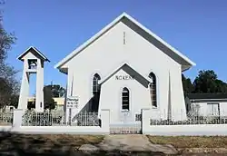 Dutch Reformed Church in Venterstad | |
 Venterstad  Venterstad | |
| Coordinates: 30.776°S 25.8°E | |
| Country | South Africa |
| Province | Eastern Cape |
| District | Joe Gqabi |
| Municipality | Walter Sisulu |
| Established | 1875 |
| Government | |
| • Type | Local Municipality |
| Area | |
| • Total | 18.1 km2 (7.0 sq mi) |
| Elevation | 1,290 m (4,230 ft) |
| Population (2011)[1] | |
| • Total | 4,989 |
| • Density | 280/km2 (710/sq mi) |
| Racial makeup (2011) | |
| • Black African | 64.9% |
| • Coloured | 33.4% |
| • Indian/Asian | 0.4% |
| • White | 0.8% |
| • Other | 0.5% |
| First languages (2011) | |
| • Xhosa | 60.3% |
| • Afrikaans | 34.6% |
| • Sotho | 2.1% |
| • Other | 2.9% |
| Time zone | UTC+2 (SAST) |
| Postal code (street) | 9798 |
| PO box | 9798 |
| Area code | 051-654- |
Town 43 km south-east of Norvalspont and 65 km west of Burgersdorp[2] It was laid out in 1875 and attained municipal status in 1895. Named after the owner of the land on which it was established, Johannes J. T. Venter.[3]
It is one of the smaller towns that currently forms part of the Gariep Local Municipality, with its seat in Burgersdorp. The town and its surrounding areas are served by a 24-hour Primary healthcare clinic (Venterstad Clinic), previously municipality-owned, but since 2010 run by the sub-district office for Health of the Eastern Cape Province. It also supports a mobile clinic and a satellite clinic at Oviston.
References
- Sum of the Main Places Venterstad and Nozizwe from Census 2011.
- SA Explorer - Venterstad distances
- "Dictionary of Southern African Place Names (Public Domain)". Human Science Research Council. p. 456.
Places adjacent to Venterstad | ||||||||||
|---|---|---|---|---|---|---|---|---|---|---|
| ||||||||||
Municipalities and communities of Joe Gqabi District Municipality, Eastern Cape | ||
|---|---|---|
District seat: Barkly East | ||
| Elundini | .svg.png.webp) Joe Gqabi District within South Africa | |
| Senqu | ||
| Walter Sisulu | ||
