Virginia State Route 89
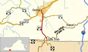
State Route 89 (SR 89) is a primary state highway in the U.S. state of Virginia. The state highway runs 7.85 miles (12.63 km) from the North Carolina state line, where the highway continues as North Carolina Highway 89 (NC 89), north to U.S. Route 58 and US 221 in Galax.
| ||||
|---|---|---|---|---|
 | ||||
| Route information | ||||
| Maintained by VDOT | ||||
| Length | 7.85 mi[1] (12.63 km) | |||
| Existed | 1940–present | |||
| Major junctions | ||||
| South end | ||||
| North end | ||||
| Location | ||||
| Counties | Grayson, City of Galax | |||
| Highway system | ||||
| ||||

Route description
_just_north_of_Camp_Zion_Road_(Virginia_State_Secondary_Route_865)_in_Galax%252C_Virginia.jpg.webp)
SR 89 begins at the North Carolina state line a short distance south of Low Gap, where the highway crosses the Eastern Continental Divide. The highway continues south as NC 89, which descends the Blue Ridge Mountains to the community of Lowgap in the valley of the Fisher River. After entering the watershed of the New River, SR 89 crosses the West Fork of Chestnut Creek and has an interchange with the Blue Ridge Parkway, which provides access to the Blue Ridge Music Center to the east. North of the parkway, the state highway intersects SR 613 (Edmonds Road), which leads west to Big Spring Bog Natural Area Preserve. SR 89 heads straight north as Skyline Highway to McCarmant Hill, where the highway leaves Grayson County and enters the independent city of Galax as Main Street. The state highway crosses Chestnut Creek twice before meeting the western end of SR 97 (Pipers Gap Road). SR 89 heads through downtown Galax before reaching its northern terminus at US 58 and US 221 (Stuart Drive).[1][2]
History
The whole route was added to the state highway system in 1928 as State Route 117.[3] It was renumbered State Route 96 in the 1933 renumbering, and in the 1940 renumbering it was renumbered State Route 89 to match North Carolina Highway 89.[4]
Major intersections
| County | Location | mi[1] | km | Destinations | Notes |
|---|---|---|---|---|---|
| Grayson | | 0.00 | 0.00 | North Carolina state line | |
| Low Gap | Interchange | ||||
| City of Galax | 6.15 | 9.90 | |||
| 7.85 | 12.63 | ||||
| 1.000 mi = 1.609 km; 1.000 km = 0.621 mi | |||||
VA 89 Truck
| |
|---|---|
| Location | Galax |
Virginia State Truck Route 89 in Galax, Virginia is Meadow Street from VA 89, one block north of the western terminus of VA 97 to US 58/221. It runs entirely along the east bank of Chestnut Creek.
References
- "2010 Traffic Data". Virginia Department of Transportation. 2010. Retrieved 2011-10-19.
- Grayson County (PDF)
- Carroll County and City of Galax (PDF)
- Google (2011-10-19). "Virginia State Route 89" (Map). Google Maps. Google. Retrieved 2011-10-19.
- "Minutes of the Meeting of the State Highway Commission of Virginia Held in Richmond, Virginia, September 27, 1928" (PDF). (409 KiB), page 10
- "Minutes of the Meeting of the State Highway Commission of Virginia, Held in Richmond, October 10, 1940" (PDF). (332 KiB), page 13
External links
| Wikimedia Commons has media related to Virginia State Route 89. |
| < SR 116 | District 1 State Routes 1928–1933 |
SR 118 > |