Walthill, Nebraska
Walthill is a village in Thurston County, Nebraska, United States, within the Omaha Reservation. The population was 780 at the 2010 census.
Walthill, Nebraska | |
|---|---|
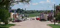 Downtown Walthill: Main Street, looking east | |
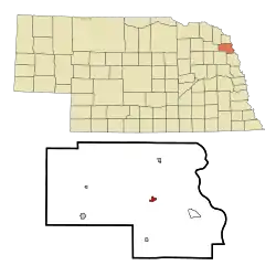 Location of Walthill, Nebraska | |
 Walthill Location within Nebraska  Walthill Location within the United States | |
| Coordinates: 42°8′55″N 96°29′26″W | |
| Country | United States |
| State | Nebraska |
| County | Thurston |
| Township | Omaha |
| Area | |
| • Total | 0.43 sq mi (1.11 km2) |
| • Land | 0.43 sq mi (1.11 km2) |
| • Water | 0.00 sq mi (0.00 km2) |
| Elevation | 1,217 ft (371 m) |
| Population | |
| • Total | 780 |
| • Estimate (2019)[3] | 798 |
| • Density | 1,864.49/sq mi (720.38/km2) |
| Time zone | UTC-6 (Central (CST)) |
| • Summer (DST) | UTC-5 (CDT) |
| ZIP code | 68067 |
| Area code(s) | 402 |
| FIPS code | 31-51245[4] |
| GNIS feature ID | 0834465[5] |
History
Walthill was platted in 1906 when the Chicago, Burlington and Quincy Railroad was extended to that point.[6] It was named for Walter "Walt" Hill, son of railroad executive James J. Hill.[7]
Geography
Walthill is located at 42°8′55″N 96°29′26″W (42.148744, -96.490434).[8] It is located within the Omaha Reservation.
According to the United States Census Bureau, the village has a total area of 0.43 square miles (1.11 km2), all land.[9]
Demographics
| Historical population | |||
|---|---|---|---|
| Census | Pop. | %± | |
| 1910 | 810 | — | |
| 1920 | 1,145 | 41.4% | |
| 1930 | 1,162 | 1.5% | |
| 1940 | 1,204 | 3.6% | |
| 1950 | 958 | −20.4% | |
| 1960 | 844 | −11.9% | |
| 1970 | 897 | 6.3% | |
| 1980 | 847 | −5.6% | |
| 1990 | 747 | −11.8% | |
| 2000 | 909 | 21.7% | |
| 2010 | 780 | −14.2% | |
| 2019 (est.) | 798 | [3] | 2.3% |
| U.S. Decennial Census[10] | |||
2010 census
At the 2010 census,[2] there were 780 people, 207 households and 158 families residing in the village. The population density was 1,814.0 inhabitants per square mile (700.4/km2). There were 240 housing units at an average density of 558.1 per square mile (215.5/km2). The racial makeup of the village was 15.6% White, 0.6% African American, 80.9% Native American, 0.1% Asian, 0.3% Pacific Islander, 0.3% from other races, and 2.2% from two or more races. Hispanic or Latino of any race were 3.3% of the population.
There were 207 households, of which 55.1% had children under the age of 18 living with them, 38.2% were married couples living together, 26.1% had a female householder with no husband present, 12.1% had a male householder with no wife present, and 23.7% were non-families. 18.4% of all households were made up of individuals, and 7.3% had someone living alone who was 65 years of age or older. The average household size was 3.77 and the average family size was 4.33.
The median age was 24.8 years. 40% of residents were under the age of 18; 10.2% were between the ages of 18 and 24; 22% were from 25 to 44; 19.8% were from 45 to 64; and 8.2% were 65 years of age or older. The gender makeup was 49.9% male and 50.1% female.
2000 census
At the 2000 census,[4] there were 909 people, 284 households and 205 families residing in the village. The population density was 2,116.1 per square mile (816.2/km2). There were 308 housing units at an average density of 717.0 per square mile (276.6/km2). The racial makeup of the village was 27.61% White, 67.88% Native American, 0.11% Asian, 0.99% from other races, and 3.41% from two or more races. Hispanic or Latino of any race were 6.38% of the population.
There were 284 households, of which 40.5% had children under the age of 18 living with them, 41.2% were married couples living together, 22.2% had a female householder with no husband present, and 27.5% were non-families. 25.4% of all households were made up of individuals, and 12.7% had someone living alone who was 65 years of age or older. The average household size was 3.20 and the average family size was 3.80.
41.3% of the population were under the age of 18, 7.6% from 18 to 24, 25.0% from 25 to 44, 14.9% from 45 to 64, and 11.3% who were 65 years of age or older. The median age was 27 years. For every 100 females, there were 95.5 males. For every 100 females age 18 and over, there were 92.1 males.
The median household income was $28,750 and the median family income was $29,500. Males had a median income of $26,719 and females $21,500. The per capita income was $10,051. About 18.2% of families and 23.0% of the population were below the poverty line, including 26.1% of those under age 18 and 16.5% of those age 65 or over.
Notable person
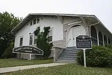
- Susan La Flesche Picotte, first Native American female physician
References
- "2019 U.S. Gazetteer Files". United States Census Bureau. Retrieved July 26, 2020.
- "U.S. Census website". United States Census Bureau. Retrieved 2012-06-24.
- "Population and Housing Unit Estimates". United States Census Bureau. May 24, 2020. Retrieved May 27, 2020.
- "U.S. Census website". United States Census Bureau. Retrieved 2008-01-31.
- "US Board on Geographic Names". United States Geological Survey. 2007-10-25. Retrieved 2008-01-31.
- "Walthill, Thurston County". Center for Advanced Land Management Information Technologies. University of Nebraska. Retrieved 23 August 2014.
- Fitzpatrick, Lillian L. (1960). Nebraska Place-Names. University of Nebraska Press. p. 140. ISBN 0-8032-5060-6. A 1925 edition is available for download at University of Nebraska—Lincoln Digital Commons.
- "US Gazetteer files: 2010, 2000, and 1990". United States Census Bureau. 2011-02-12. Retrieved 2011-04-23.
- "US Gazetteer files 2010". United States Census Bureau. Retrieved 2012-06-24.
- "Census of Population and Housing". Census.gov. Retrieved June 4, 2015.
Municipalities and communities of Thurston County, Nebraska, United States | ||
|---|---|---|
| Villages | Map of Nebraska highlighting Thurston County | |
| CDP | ||
| Townships | ||
| Indian reservations | ||
| Footnotes | ‡This populated place also has portions in an adjacent county or counties | |
| ||
