Washington State Route 117
State Route 117 (SR 117) is a short, 1.40-mile (2.25 km) long state highway located entirely within Port Angeles, the county seat of Clallam County, in the U.S. state of Washington. The short roadway, named the Tumwater Truck Route, serves the waterfront of Port Angeles and intersects two streets and crosses under another street on a short bridge. Beginning at an interchange with U.S. Route 101 (US 101), the highway travels northeast to terminate at Marine Drive. SR 117 was first established in 1991, but a road parallel to the current roadway had existed since 1966.
| ||||
|---|---|---|---|---|
| Tumwater Truck Road POW/MIA Memorial Highway | ||||
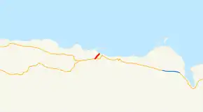 SR 117 is highlighted in red. | ||||
| Route information | ||||
| Auxiliary route of US 101 | ||||
| Defined by RCW 47.17.221 | ||||
| Maintained by WSDOT | ||||
| Length | 1.40 mi[1] (2.25 km) | |||
| Existed | 1991[2][3]–present | |||
| Major junctions | ||||
| South end | ||||
| North end | Marine Drive in Port Angeles | |||
| Highway system | ||||
| ||||

Route description
SR 117 begins as the Tumwater Truck Road at an interchange with U.S. Route 101 (US 101) in southwest Port Angeles. The interchange only serves traffic from US 101 eastbound driving onto SR 117 northbound and motorists driving from the route southbound onto US 101 westbound, however, left turns are allowed to serve the missing movements.[4] Traveling north, the highway intersects Lauridsen Boulevard and crosses under 8th Street. Between 8th Street and the Port Angeles waterfront, a daily average of 7,400 motorists accessed the roadway in 2008.[5] After the 8th Street bridge, the road intersects 3rd Street and terminates at Marine Drive, which continues east as 1st Street to US 101.[6][7]
History
SR 117 originated in 1991,[2] but a short local street connecting the waterfront with U.S. Route 101 (US 101) had existed in 1966.[8] In 1991, the Washington State Legislature established SR 117 and the roadway has not been realigned since 1991.[3][9] During a severe winter storm on November 27, 2006, the Port Angeles Police Department closed both ends of the highway due to treacherous conditions.[10] On December 15, 2006, a wind storm caused trees near the roadway to block the highway and the route had to be shut down.[11] On August 7, 2007, the city of Port Angeles announced that the 8th Street bridge over the Tumwater Truck Route would be closed on August 20, 2007.[12] A detour was set for both 8th Street and the truck route; trucks were routed onto US 101 (Lincoln Street) and Marine Drive / Front Street.[13] Starting on April 1, 2008, the new bridge's girders started to arrive at the construction site.[14] The last girders arrived on April 9 and the highway was reopened.[15][16] On August 1, the roadway was closed for another month to be reconstructed.[17] SR 117 was designated as the POW/MIA Memorial Highway by the state transportation commission in 2013.[18]
Major intersections
The entire highway is in Port Angeles, Clallam County.
| mi[1] | km | Destinations | Notes | ||
|---|---|---|---|---|---|
| 0.00 | 0.00 | Southern terminus; westbound entrance and eastbound exit | |||
| 1.40 | 2.25 | Marine Drive | Northern terminus | ||
| 1.000 mi = 1.609 km; 1.000 km = 0.621 mi | |||||
References
- Washington State Department of Transportation (2008). "State Highway Log: Planning Report, SR 2 to SR 971" (PDF). Retrieved August 12, 2009.
- Washington State Legislature (1991). "RCW 47.17.221: State route No. 117". Retrieved August 12, 2009.
- Washington House of Representatives (1991). "Chapter 342, Laws of 1991: State Highway Routes — Revisions To (House Bill 5801)". Washington State Legislature. Retrieved August 12, 2009.
- Washington State Department of Transportation (June 25, 2009). "SR 101; Junction SR 117 / Doyle Road" (PDF). Retrieved August 12, 2009.
- Washington State Department of Transportation (2008). "2008 Annual Traffic Report" (PDF). Retrieved August 12, 2009.
- Google (August 12, 2009). "State Route 117" (Map). Google Maps. Google. Retrieved August 12, 2009.
- Pacific Northwest: Washington, Oregon, Western Idaho, Southwestern British Columbia (Map) (6th ed.). 1 inch = 3,800 feet. The Thomas Guide. Cartography by NAVTEQ. Thomas Bros., Rand McNally. 2004. p. 261. ISBN 0-528-99511-1.
- Victoria, 1966 (Map). 1:250,000. Cartography by United States Geological Survey. University of Texas at Austin. 1966. Retrieved August 12, 2009.
- Washington State Highways, 2008–2009 (PDF) (Map) (2008–09 ed.). 1:842,000. Cartography by United States Geological Survey. Washington State Department of Transportation. 2008. § C2. Retrieved August 12, 2009.
- KONP staff (November 27, 2006). "Snow problems continue for Peninsula". Port Angeles, Washington: KONP. Retrieved August 12, 2009.
Port Angeles Police closed both ends of the Tumwater Truck Route earlier this morning due to treacherous conditions.
- KONP staff (December 15, 2006). "Winds roar through PA, downing". Port Angeles, Washington: KONP. Retrieved August 12, 2009.
Yet more trees are down on the Tumwater Truck Route.
- KONP staff (August 7, 2007). "Firm date set for 8th Street bridge shutdown". Port Angeles, Washington: KONP. Retrieved August 12, 2009.
- Traffic Management: Port Angeles 8th Street Bridge Replacement Project (PDF) (Map). City of Port Angeles, Washington. 2007. Retrieved August 12, 2009.
- KONP staff (March 27, 2008). "Huge girders coming for new 8th Street bridge". Port Angeles, Washington: KONP. Retrieved August 12, 2009.
- KONP staff (April 9, 2008). "Last bridge girders arrive, Truck Route reopens". Port Angeles, Washington: KONP. Retrieved August 12, 2009.
- KONP staff (April 10, 2008). "Girders placed, traffic rolls on Truck Route". Port Angeles, Washington: KONP. Retrieved August 12, 2009.
- KONP staff (August 1, 2008). "PA's Truck Route to close for a month". Port Angeles, Washington: KONP. Retrieved August 12, 2009.
- "Ceremony to mark truck route's new designation as POW/MIA highway". Peninsula Daily News. September 20, 2013. Retrieved October 1, 2018.