Wautoma, Wisconsin
Wautoma is a city in Waushara County, Wisconsin, United States. The population was 2,218 at the 2010 census. Wautoma is the county seat of Waushara County.
Wautoma, Wisconsin | |
|---|---|
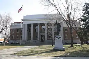
 Looking west at downtown Wautoma, Wisconsin | |
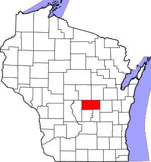
 Location of Wautoma in Waushara County, Wisconsin. | |
| Coordinates: 44°4′17″N 89°17′23″W | |
| Country | |
| State | |
| County | Waushara |
| Area | |
| • Total | 2.83 sq mi (7.34 km2) |
| • Land | 2.79 sq mi (7.23 km2) |
| • Water | 0.04 sq mi (0.11 km2) |
| Elevation | 863 ft (263 m) |
| Population | |
| • Total | 2,218 |
| • Estimate (2019)[4] | 2,142 |
| • Density | 767.74/sq mi (296.46/km2) |
| Time zone | UTC-6 (Central (CST)) |
| • Summer (DST) | UTC-5 (CDT) |
| ZIP Code | 54982 |
| Area code(s) | 920 |
| FIPS code | 55-84625 |
| GNIS feature ID | 1576330 [2] |
| Website | http://www.cityofwautoma.com/ |
The city consists of three noncontiguous areas: one is entirely within the Town of Wautoma, the second is entirely within the Town of Dakota, and the third straddles the boundary between the two towns.
Wautoma calls itself the "Christmas tree capital of the world".[5][6][7][8] The Kirk Company of Tacoma, Washington, operated the "Wautoma plantation" of more than 10,000 acres (4,000 ha) of Christmas trees, beginning in 1953.[9]
On August 29, 1992, the town was struck by a half-mile wide F-3 tornado, killing 2 people, injuring 30 others, and causing over $5 million in damage.[10]
Geography
According to the United States Census Bureau, the city has a total area of 2.72 square miles (7.04 km2), of which, 2.68 square miles (6.94 km2) is land and 0.04 square miles (0.10 km2) is water.[11]
Demographics
| Historical population | |||
|---|---|---|---|
| Census | Pop. | %± | |
| 1880 | 295 | — | |
| 1910 | 964 | — | |
| 1920 | 1,046 | 8.5% | |
| 1930 | 1,044 | −0.2% | |
| 1940 | 1,180 | 13.0% | |
| 1950 | 1,376 | 16.6% | |
| 1960 | 1,466 | 6.5% | |
| 1970 | 1,624 | 10.8% | |
| 1980 | 1,629 | 0.3% | |
| 1990 | 1,784 | 9.5% | |
| 2000 | 1,998 | 12.0% | |
| 2010 | 2,218 | 11.0% | |
| 2019 (est.) | 2,142 | [4] | −3.4% |
| U.S. Decennial Census[12] | |||
2010 census
As of the census[3] of 2010, there were 2,218 people, 945 households, and 487 families living in the city. The population density was 827.6 inhabitants per square mile (319.5/km2). There were 1,061 housing units at an average density of 395.9 per square mile (152.9/km2). The racial makeup of the city was 88.3% White, 1.4% African American, 0.7% Native American, 0.4% Asian, 6.3% from other races, and 2.9% from two or more races. Hispanic or Latino of any race were 15.8% of the population.
There were 945 households, of which 28.7% had children under the age of 18 living with them, 32.6% were married couples living together, 14.4% had a female householder with no husband present, 4.6% had a male householder with no wife present, and 48.5% were non-families. 44.1% of all households were made up of individuals, and 21.7% had someone living alone who was 65 years of age or older. The average household size was 2.21 and the average family size was 3.13.
The median age in the city was 35.4 years. 25.3% of residents were under the age of 18; 9.5% were between the ages of 18 and 24; 25.2% were from 25 to 44; 22.8% were from 45 to 64; and 17.2% were 65 years of age or older. The gender makeup of the city was 50.5% male and 49.5% female.
2000 census
As of the census[13] of 2000, there were 1,998 people, 806 households, and 429 families living in the city. The population density was 800.8 people per square mile (308.6/km2). There were 877 housing units at an average density of 351.5 per square mile (135.4/km2). The racial makeup of the city was 94.04% White, 1.10% Black or African American, 0.70% Native American, 0.85% Asian, 2.00% from other races, and 1.30% from two or more races. 7.21% of the population were Hispanic or Latino of any race.
There were 806 households, out of which 27.2% had children under the age of 18 living with them, 37.7% were married couples living together, 11.0% had a female householder with no husband present, and 46.7% were non-families. 40.4% of all households were made up of individuals, and 20.1% had someone living alone who was 65 years of age or older. The average household size was 2.20 and the average family size was 3.04.
In the city, the population was spread out, with 24.0% under the age of 18, 9.4% from 18 to 24, 25.5% from 25 to 44, 17.6% from 45 to 64, and 23.5% who were 65 years of age or older. The median age was 39 years. For every 100 females, there were 98.2 males. For every 100 females age 18 and over, there were 89.5 males.
The median income for a household in the city was $31,723, and the median income for a family was $37,500. Males had a median income of $27,546 versus $19,648 for females. The per capita income for the city was $16,006. About 5.2% of families and 11.5% of the population were below the poverty line, including 10.7% of those under age 18 and 18.3% of those age 65 or over.
Transportation
Wautoma is served by the Wautoma Municipal Airport (FAA LID: Y50).
Media
News media
- The Waushara Argus is the weekly newspaper.
Radio
- WAUH radio broadcasts at 102.3 FM.
High school sports
Wautoma High School has won five state championships, three in boys' track and field, one in boys' basketball, and one in football. In 1980, Wautoma High School won the Class B State Basketball Championship.[14]
Notable people
- Jared Abbrederis, Green Bay Packers, Detroit Lions, and Wisconsin Badgers wide receiver
- Robert E. Behnke, Wisconsin State Representative
- William Belter, Wisconsin State Representative
- Robyn J. Blader, U.S. National Guard general
- George M. Byse, Wisconsin State Representative
- Boyd A. Clark, Wisconsin State Representative and jurist
- Richard W. Hubbell, Wisconsin State Representative
- Edward F. Kileen, Wisconsin State Senator
- Robert L. D. Potter, Wisconsin State Senator
- June Wandrey, World War II veteran, writer
- William C. Webb, Wisconsin and Kansas politician and jurist
Images
 Road sign, looking west down Highway 21
 Wautoma City Hall
 Waushara County courthouse
 Looking west at the sign for Wautoma
 Public library
 Wautoma High School
 The former Waushara Training School in Wautoma
See also
References
- "2019 U.S. Gazetteer Files". United States Census Bureau. Retrieved August 7, 2020.
- "US Board on Geographic Names". United States Geological Survey. 2007-10-25. Retrieved 2008-01-31.
- "U.S. Census website". United States Census Bureau. Retrieved 2012-11-18.
- "Population and Housing Unit Estimates". United States Census Bureau. May 24, 2020. Retrieved May 27, 2020.
- Hoffmann, Gregg (December 14, 2004). "So, where is the Christmas tree capital?". OnMilwaukee.com. Retrieved December 25, 2014.
- Foreman, Chris (December 20, 2004). "'Tis the season for tree farmers". Pittsburgh Tribune-Review. Retrieved December 25, 2014.
- Salas, Rafael Francisco (September 24, 2014). "Christmas Tree Groves". Milwaukee Journal Sentinel. Retrieved December 25, 2014.
- Johnson, Mickey; Kehr, Roland (2002). Wingshooter's Guide to Wisconsin: Upland Birds and Waterfowl. Wilderness Adventures Press. p. 176. ISBN 978-1-885106-86-5. Retrieved 25 December 2014.
- Kahler, Kathryn A. (December 2014). "Of Christmas trees, long, long ago". Wisconsin Natural Resources. Wisconsin Department of Natural Resources: 2. Retrieved December 25, 2014.
- "Tornado in Wisconsin Kills 2 and Injures 30". New York Times. September 1, 1992. Retrieved February 12, 2015.
- "US Gazetteer files 2010". United States Census Bureau. Retrieved 2012-11-18.
- "Census of Population and Housing". Census.gov. Retrieved June 4, 2015.
- "U.S. Census website". United States Census Bureau. Retrieved 2008-01-31.
- http://www.wiaawi.org/Portals/0/PDF/Results/Basketball_Boys/teamchamps.pdf
External links
| Wikimedia Commons has media related to Wautoma, Wisconsin. |
- Official website
- Wautoma Public Library
- Sanborn fire insurance map: 1911
