Wawayanda, New York
Wawayanda is a town in Orange County, New York, in the United States. The population was 7,266 as recorded by the 2010 census. The town of Wawayanda is in the western part of the county, south of Middletown.
Wawayanda, New York | |
|---|---|
 Location in Orange County and the state of New York. | |
 Wawayanda, New York Location within the state of New York | |
| Coordinates: 41°23′36″N 74°27′24″W | |
| Country | United States |
| State | New York |
| County | Orange |
| Area | |
| • Total | 35.03 sq mi (90.72 km2) |
| • Land | 34.72 sq mi (89.92 km2) |
| • Water | 0.31 sq mi (0.80 km2) |
| Elevation | 558 ft (170 m) |
| Population (2010) | |
| • Total | 7,266 |
| • Estimate (2016)[2] | 7,315 |
| • Density | 210.69/sq mi (81.35/km2) |
| Time zone | UTC-5 (Eastern (EST)) |
| • Summer (DST) | UTC-4 (EDT) |
| FIPS code | 36-78839[3] |
| GNIS feature ID | 0979610[4] |
| Website | Town website |
History
The town of Wawayanda was established in 1849 from the town of Minisink. It had been first settled after the American Revolution.
Geography
According to the United States Census Bureau, the town has a total area of 35.0 square miles (91 km2), of which, nearly 35.0 square miles (91 km2) is land and 0.1 square miles (0.26 km2) (0.14%) is water.
The town is bordered on the north by the city of Middletown and the town of Wallkill, east by the town of Goshen, south by the town of Warwick, southwest by the town of Minisink, west by the town of Greenville, with a very short shared border with the town of Mount Hope on the northwest.
Interstate 84 and U.S. Route 6 (US 6, the Grand Army of the Republic Highway) are important east-west highways. New York State Route 17M (NY 17M) crosses the northern part of the town. NY 284 is a north-south highway.
Demographics
| Historical population | |||
|---|---|---|---|
| Census | Pop. | %± | |
| 1860 | 2,085 | — | |
| 1870 | 1,900 | −8.9% | |
| 1880 | 1,879 | −1.1% | |
| 1890 | 1,625 | −13.5% | |
| 1900 | 1,539 | −5.3% | |
| 1910 | 1,603 | 4.2% | |
| 1920 | 1,689 | 5.4% | |
| 1930 | 1,946 | 15.2% | |
| 1940 | 2,218 | 14.0% | |
| 1950 | 2,435 | 9.8% | |
| 1960 | 3,229 | 32.6% | |
| 1970 | 3,408 | 5.5% | |
| 1980 | 4,298 | 26.1% | |
| 1990 | 5,518 | 28.4% | |
| 2000 | 6,273 | 13.7% | |
| 2010 | 7,266 | 15.8% | |
| 2016 (est.) | 7,315 | [2] | 0.7% |
| U.S. Decennial Census[5] | |||
As of the 2010 census, the population was 7,266. The racial makeup was 80.7% white, 12.2% Hispanic, 5.0% African-American, 1.9% Asian, and 0.2% Native American.
As of the census[3] of 2000, there were 6,273 people, 2,095 households, and 1,719 families residing in the town. The population density was 179.3 people per square mile (69.2/km2). There were 2,174 housing units at an average density of 62.1 per square mile (24.0/km2). The racial makeup of the town was 92.86% white, 1.75% African American, 0.37% Native American, 1.61% Asian, 0.02% Pacific Islander, 1.90% from other races, and 1.50% from two or more races. Hispanic or Latino of any race were 5.88% of the population.
There were 2,095 households, out of which 43.2% had children under the age of 18 living with them, 68.7% were married couples living together, 9.5% had a female householder with no husband present, and 17.9% were non-families. 14.6% of all households were made up of individuals, and 5.5% had someone living alone who was 65 years of age or older. The average household size was 2.98 and the average family size was 3.29.
In the town, the population was spread out, with 29.5% under the age of 18, 6.1% from 18 to 24, 30.1% from 25 to 44, 24.7% from 45 to 64, and 9.5% who were 65 years of age or older. The median age was 37 years. For every 100 females, there were 100.6 males. For every 100 females age 18 and over, there were 96.4 males.
The median income for a household in the town was $61,885, and the median income for a family was $67,479. Males had a median income of $42,491 versus $27,993 for females. The per capita income for the town was $21,856. About 2.8% of families and 3.7% of the population were below the poverty line, including 2.0% of those under age 18 and 4.3% of those age 65 or over.
Hamlets of Wawayanda
- Denton – a hamlet near the east town line on NY 17M.
- Gardnerville – a hamlet on County Route 62 (CR 62) in the south part of the town.
- Millsburgh – a hamlet south of South Centerville on CR 22.
- New Hampton – a hamlet on US 6 in the northeast part of Wawayanda.
- Pellets Island – a location at the east town line.
- Ridgebury – a hamlet east of Slate Hill.
- Slate Hill – a hamlet on US 6 near the east town line.
- South Centerville – a hamlet located on US 6 at CR 22, near the west town line.
Former town supervisors
Denise Quinn, (2020- ), Republican
John Razzano, (2006-2020), Republican
Wayne Skinner, (2004–2006), Democrat
Thomas Deblock, (1996–2004), Republican
Jeffrey K. Bridges Jr., (1992–1996), Republican
Ed. Flynn, (1988–1992), Democrat
Brice "Buzzy" Flynn, (1970–1988), Democrat
See also
- Wawayanda Patent, 1703 land grant
- Wawayanda State Park, a nearby New Jersey state park of the same name
References
- "2016 U.S. Gazetteer Files". United States Census Bureau. Retrieved Jul 5, 2017.
- "Population and Housing Unit Estimates". Retrieved June 9, 2017.
- "U.S. Census website". United States Census Bureau. Retrieved 2008-01-31.
- "US Board on Geographic Names". United States Geological Survey. 2007-10-25. Retrieved 2008-01-31.
- "Census of Population and Housing". Census.gov. Retrieved June 4, 2015.
External links
- Town of Wawayanda Website
- Town of Wawayanda Facebook
- Shannen Park Facebook
- Slate Hill Fire District
- New Hampton Fire Department
| Wikimedia Commons has media related to Wawayanda, New York. |
Municipalities and communities of Orange County, New York, United States | ||
|---|---|---|
| Cities | 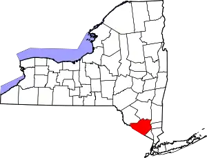 | |
| Towns | ||
| Villages | ||
| CDPs | ||
| Other hamlets |
| |
| ||
| Authority control |
|---|
