U.S. Route 6 in New York
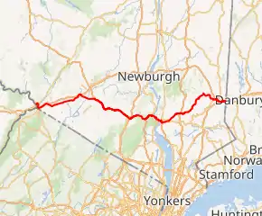
U.S. Route 6 (US 6) in New York is a 77.85-mile (125.29 km) stretch of cross-country route that spans from the Pennsylvania state line at Port Jervis to the Connecticut state line east of Brewster. Near both ends it runs in close proximity to Interstate 84 (I-84), which otherwise takes a more northerly route through Downstate New York. US 6, meanwhile, skirts the northern fringe of the New York Metropolitan Area.
| |||||||
|---|---|---|---|---|---|---|---|
US 6 highlighted in red, with NY 6N and US 6 Alt highlighted in blue | |||||||
| Route information | |||||||
| Maintained by NYSDOT, Westchester County, the city of Port Jervis, Joint Interstate Bridge Commission, NYSDEC and NYSBA | |||||||
| Length | 77.85 mi[1] (125.29 km) | ||||||
| Existed | 1927[2]–present | ||||||
| Major junctions | |||||||
| West end | |||||||
| |||||||
| East end | |||||||
| Location | |||||||
| Counties | Orange, Westchester, Putnam | ||||||
| Highway system | |||||||
| |||||||

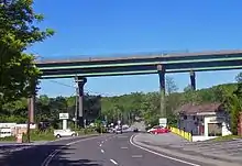
Except for a section concurrent with the expressway portion of New York State Route 17 (the future I-86) and another brief, similar stretch in Peekskill, US 6 is a two-lane road in New York. Two stretches are shared with US 202. It goes through three of New York's traffic circles, more than any other highway in the state, and is part of the only concurrency of three U.S. routes in the state.
US 6 is not as important a transportation artery in New York as it in some other states. The route does, however, pass through some of the region's more memorable scenery, particularly the Hudson Highlands in the form of Harriman and Bear Mountain state parks. It crosses the Hudson River at the historic Bear Mountain Bridge. Other highlights include the Shawangunk Ridge in the west and New York City's reservoirs in the east.
Route description
The Hudson River roughly bisects New York's section of US 6, although more of it is on the river's western side. Despite its many curves and turns, the road stays in a generally east–west direction.
West of Harriman
US 6 crosses the Delaware River into New York concurrent with US 209 from Matamoras via the Mid-Delaware Bridge. Upon entering Port Jervis, they become Pike Street. Two blocks from the bridge, the highways cross under the wide grassy strip that once carried the Erie Railroad's Main Line and pass the city's Metro-North station, the most remote from New York on the extensive commuter rail network. A few blocks further north, at the Park Avenue traffic light, NY 42 and NY 97 begin to the left while US 6 and US 209 turn right, now West Main Street.[3]
Two blocks later, the highways having not even come a mile from the state line, US 209 splits to the left at Kingston Avenue. US 6 continues to follow West Main past Port Jervis Middle School and Bon Secours Hospital,[4] veering south to cross under the railroad tracks and then over the Neversink River. At a three-way junction with short County Route 15 (CR 15), US 6 reaches the Port Jervis city limit. Signs point to New Jersey Route 23, which begins a few hundred feet to the south, just past the I-84 overpass.[3]

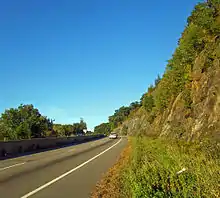
From here traffic on US 6 grows lighter as it parallels I-84 for the next 17 miles (27 km). Trucks going through this stretch are limited to 10 tons (9.1 tonnes). It slowly traverses up the Shawangunk Ridge alongside the Interstate Highway and then down again. Just before exit 3, it crosses under I-84 again. After putting at least a mile between the two, US 6 starts to run a long straight course, as Grand Army of the Republic Highway, through the wetlands of Greenville, then through gently rolling hills taking it to South Centreville, where Minisink Valley High School and the district's other schools are concentrated. At the hamlet of Slate Hill, NY 284, another route down to New Jersey, comes in from the south.[3]
US 6 continues through very rural countryside through here. Shortly before Middletown, it crosses over I-84 and turns right onto NY 17M, crossing over the Interstate Highway yet again. This is US 6's last crossing of I-84 west of the Hudson River.[3]
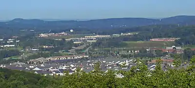
The overlap between US 6 and NY 17M continues for another 5 miles (9 km), crossing the Wallkill River, through slightly more developed countryside to Goshen, where the two routes join the NY 17 freeway (future I-86) at exit 123. NY 17M leaves the freeway several exits to the east, but US 6 stays with it for 13 miles (21 km), connecting to NY 17A, NY 207, NY 94 and NY 208 in the villages of Goshen, Chester, and Monroe respectively. It breaks from the freeway outside of Harriman by way of a long overpass that leaves just before the Quickway ends at the junction with the north–south portion of NY 17, NY 32 and the New York State Thruway, an area often jammed with traffic from nearby Woodbury Common Premium Outlets on busy weekends. Another portion of traffic is bound for the United States Military Academy at West Point, per the signs on the Thruway directing drivers to use eastbound US 6 for that purpose.[3]
Long Mountain & Palisades Parkways
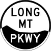
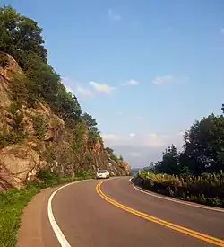
With the Thruway behind, US 6 climbs the side of a mountain, just as it does after Port Jervis. A small pullout area reveals views of the mall and the area around the exit. At the top lies Harriman State Park, where US 6 becomes Long Mountain Parkway, a 7-mile (11 km) stretch with no development. NY 293 leaves to the north to West Point's upper gates and the road widens briefly to include a middle turn lane. After dropping past a lake and then rising again, the Long Path long-distance hiking trail crosses the road on its way to the feature that gives this section of the highway its name. Driveways to the south lead to private camps that have housed various area hiking clubs since the 1920s.[3]
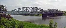
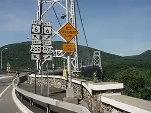
A long descent leads to Long Mountain Circle, where Seven Lakes Drive crosses and US 6 joins Palisades Interstate Parkway, descending slowly through a very scenic three miles (5 km) through Bear Mountain State Park between Bear Mountain to the south and Popolopen Torne to the north into another roundabout, the busy Bear Mountain Circle, where the parkway ends and US 6 intersects US 9W and US 202. The latter joins US 6 to cross the Hudson River via the Bear Mountain Bridge. The rocky slopes of Anthony's Nose loom ahead. A $1.50 toll is charged in this direction. The white blazes of the Appalachian Trail (AT) are also visible on the lamppost.[3]
East of the Hudson River
At the east end of the bridge, the AT turns north along NY 9D, which begins here. Routes 6 and 202 turn right and begin a four-mile (6.4-km) descent via Bear Mountain Bridge Road along the edge of the mountain to Peekskill. Pulloffs along this winding stretch allow drivers to take in sweeping views of that city, Haverstraw Bay and Dunderberg Mountain across the river at the southern end of the Hudson Highlands. The road finally reaches US 6's third traffic circle just north of the city limit. Here US 9 joins the two highways for an 0.7-mile (1.2 km) concurrency, the only combination of three U.S. highways in the state. At a traffic light south of the circle, Bear Mountain Parkway goes off to the east while the concurrency becomes the upper end of the Croton Expressway.[3]
US 6 and US 202 separate from US 9 at the first interchange and pick up NY 35, which begins here. The three routes follow Main Street for 0.8 mile (1.4 km) to South Broad Street, where US 202 and NY 35 turn south while US 6 continues east out of the city.[3]
Northeast of Peekskill, US 6 works its way north, through the hamlet of Mohegan Lake and Shrub Oak, where it meets the Taconic State Parkway by way of an interchange. It continues east, just south of the county line, into Jefferson Valley and past Oceola Lake, where NY 6N, the lone spur of US 6 in New York, begins a northerly loop. At Baldwin Place, it veers north again and enters Putnam County.[3]
Just past the county line, NY 118 comes to its northern end.[5] US 6 runs ever more northerly, meeting NY 6N's other end as it follows the south shore of Lake Mahopac through the village of Mahopac.[3]
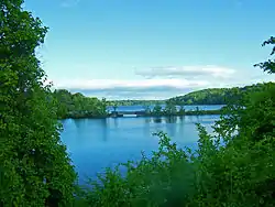
The combined influence of the New York City water supply system's Croton Watershed, which includes most of the bodies of water along this stretch of US 6, and affluent residents who build on very large lots, keeps this area lightly developed. Leaving Mahopac, US 6 curves past the south end of West Branch Reservoir and controlled Lake Gleneida to its next highway junction, the east end of NY 52 at Reed Memorial Library just south of the county seat, Carmel. The highway immediately turns toward the south again, curving around Middle Branch Reservoir at Tilly Foster to the west terminus of NY 312. At this junction, signs for the Southeast station on the Harlem Line of the Metro-North Railroad are a reminder that this is still commuter country. Also appearing are the first signs for I-84, whose interchange with NY 312 is a short distance away, since Middletown.[3]
A long bend through countryside increasingly anticipating New England brings US 6 over the Metro-North tracks and to a right turn along them takes US 6 into Brewster. At that village's Metro-North station, the highway again turns left, bringing it to an intersection just outside the village where it is reunited with US 202, here concurrent with NY 22. After crossing under the interstate, the road encounters a half-cloverleaf. NY 22 turns left and leaves for Pawling and points north. I-684 is a short distance to the south, accessed by way of NY 981B, a short reference route occupying the I-684 right-of-way between I-84 and NY 22.[6] US 6 and US 202 remain parallel with I-84, following the southern shore of one of the lakes of East Branch Reservoir. After one last highway terminus, NY 121's northern end, both cross into Danbury, Connecticut, right next to the Interstate Highway's Mill Plain Road exit.[3]
History
Origins and designation
The portion of US 6 in New York east of Fort Montgomery was originally designated as part of NY 37 in the mid-1920s.[7][8] NY 37 began at NY 17 (now NY 17M) in Monroe and followed what is now CR 105 and NY 32 east to Central Valley. From there, it continued to Fort Montgomery via Estrada Road and modern NY 293, NY 218, and US 9W.[8] When the U.S. Highway System was created on November 11, 1926, there was a gap in US 6 between the New York–Pennsylvania border at Port Jervis and the Connecticut state line east of Brewster.[9] The gap remained in the first official route log published by AASHO in 1927; however, US 6 now entered New York at Port Jervis and followed what is now US 209 northeast to Kingston, where the west half of US 6 ended at US 9W. The eastern half of US 6 still began at the Connecticut state line east of Brewster.[2] In 1928, AASHO modified the definition of US 6, placing the route along a new alignment further south in the state in order to eliminate the gap in the designation.[2] It now followed a previously unnumbered highway from Port Jervis to Slate Hill and overlapped with the pre-existing NY 8 from Slate Hill to Middletown and NY 17 (modern NY 17M) between Middletown and Monroe. From Monroe to Brewster, US 6 replaced NY 37.[10][11] The former routing of US 6 between Port Jervis and Kingston became US 6N.[2] US 6 was realigned again c. 1934 to bypass the West Point Military Academy to the south. Its former alignment through the grounds became NY 293.[12][13]
Realignments
US 6 originally followed a more northerly alignment between Shrub Oak and Mahopac that took the route through Mahopac Falls.[11] In the mid-1930s, US 6 was realigned to follow a new highway to the south that went directly between the two locations.[13][14] The route's former alignment via Mahopac Falls was redesignated as NY 6N c. 1938.[15][16] In the early 1950s, construction began on the portion of the Quickway east of Goshen. The Goshen–Chester and Chester–Harriman segments of the Quickway were completed in October 1954 and August 1955, respectively.[17][18] The two segments of highway became part of a realigned US 6 and NY 17 upon opening. The original surface alignment of US 6 became part of NY 17M. Plans to construct a highway directly linking Harriman to the south end of NY 293 in Harriman State Park were proposed as early as 1954;[19][20] however, construction on the road did not begin until the mid-1960s. The highway opened to traffic by 1968 as part of a rerouted US 6.[21][22]
In the town of Yorktown, US 6 was originally routed along East Main Street in the areas around the hamlets of Shrub Oak and Jefferson Valley. At some point between 1968 and 1973, the portion of US 6 between the Taconic State Parkway and Curry Street was moved onto a new two-lane roadway bypassing Jefferson Valley to the south.[22][23] The segment between Strawberry Road and the parkway was moved onto a new highway bypassing Shrub Oak to the north sometime in the late 1970s or early 1980s.[24][25] The old alignment of US 6 west of NY 6N is now a town-maintained road designated as CR 1309 by Westchester County for planning purposes. The segment east of NY 6N became an extension of that route and was realigned slightly to meet US 6 at a 90-degree angle.[26] In 1993, the interchange with the Taconic State Parkway and NY 132 was reconstructed and US 6 was widened to two lanes in each direction through the interchange.
Future
The New York Department of Transportation started a year-long construction project in October 2019 in Brewster to rebuild the US 6 bridge over Metro North Railroad's Harlem Line and to build a direct intersection with Michael Neuner Drive.[27]
Major intersections
| County | Location | mi[1] | km | Exit | Destinations | Notes |
|---|---|---|---|---|---|---|
| Orange | Port Jervis | 0.00 | 0.00 | Bridge over Delaware River; continuation into Pennsylvania | ||
| 0.30 | 0.48 | Interchange | ||||
| 0.38 | 0.61 | Southern terminus of NY 42 and NY 97 | ||||
| 0.70 | 1.13 | Eastern end of concurrency with US 209 | ||||
| 2.47 | 3.98 | Northern terminus of Route 23, access via unsigned CR 15 | ||||
| Greenville | 6.60 | 10.62 | Southern terminus of CR 35; northern terminus of CR 55 | |||
| Slate Hill | 14.25 | 22.93 | Northern terminus of NY 284 | |||
| Middletown | 17.75 | 28.57 | Western end of NY 17M concurrency | |||
| 18.16 | 29.23 | Exit 15 on I-84 | ||||
| Goshen | 22.91 | 36.87 | Western end of freeway | |||
| West Main Street Extension / Matthews Street | Westbound entrance only | |||||
| 23.21 | 37.35 | Western end of Future I-86/NY 17 concurrency; westbound exit and eastbound entrance; exit 123 on NY 17 | ||||
| 23.23 | 37.39 | 124 | Western termini of NY 17A and NY 207 | |||
| 24.03 | 38.67 | 125 | Eastern end of NY 17M concurrency | |||
| Chester | 27.21 | 43.79 | 126 | |||
| 127 | Greycourt Road – Sugar Loaf, Warwick | Westbound exit and eastbound entrance | ||||
| Blooming Grove | 128 | Westbound exit only | ||||
| 129 | Museum Village Road | No westbound entrance | ||||
| Monroe | 32.51 | 52.32 | 130 | |||
| Harriman | 35.44 | 57.04 | Eastern end of Future I-86/NY 17 concurrency; exit 130A on NY 17 | |||
| 36.29 | 58.40 | |||||
| Harriman State Park | 39.12 | 62.96 | Southern terminus of NY 293; western terminus of US 6 Truck | |||
| 42.49 | 68.38 | Western end of Seven Lakes Drive concurrency; exit 18 on the Palisades Parkway; Long Mountain Circle | ||||
| 42.96 | 69.14 | Western terminus of Palisades Parkway concurrency | ||||
| Bear Mountain State Park | 19 | Eastern end of Seven Lakes Drive concurrency | ||||
| 45.49 | 73.21 | Western terminus of concurrency with US 202; northern terminus of the Palisades Parkway; eastern terminus of US 6 Truck; Bear Mountain Circle | ||||
| Eastern end of freeway | ||||||
| Hudson River | 45.64 | 73.45 | Bear Mountain Bridge (only tolled eastbound) Accepts E-ZPass and Cash | |||
| Westchester | Cortlandt | 46.09 | 74.17 | Southern terminus of NY 9D | ||
| 49.73 | 80.03 | Western end of US 9 concurrency; Annsville Circle | ||||
| Peekskill | 49.78 | 80.11 | Western terminus of Bear Mountain Parkway | |||
| 50.55 | 81.35 | Eastern end US 9 concurrency; western end NY 35 concurrency; western terminus of NY 35 | ||||
| 51.30 | 82.56 | Eastern end of US 202/NY 35 concurrency | ||||
| Cortlandt | 52.97 | 85.25 | ||||
| Shrub Oak | 57.23 | 92.10 | Northern terminus of NY 132 | |||
| 57.44 | 92.44 | Exit 20 on the Taconic Parkway | ||||
| Jefferson Valley | 59.29 | 95.42 | Western terminus of NY 6N | |||
| Putnam | Baldwin Place | 60.97 | 98.12 | Northern terminus of NY 118; southern terminus of CR 37 | ||
| Mahopac | 63.41 | 102.05 | Eastern terminus of NY 6N | |||
| Carmel | 68.62 | 110.43 | Eastern terminus of NY 52 | |||
| Southeast | 70.93 | 114.15 | Western terminus of NY 312 | |||
| Brewster | 73.10 | 117.64 | ||||
| 73.90 | 118.93 | Western end of US 202 and NY 22 concurrency | ||||
| 74.82 | 120.41 | Eastern end of NY 22 concurrency; northern terminus of I-684; exit 10 on I-684; exit 68 on I-84 | ||||
| Southeast | 75.60 | 121.67 | Northern terminus of NY 121; exit 69 on I-84 | |||
| 77.85 | 125.29 | Continuation into Connecticut | ||||
1.000 mi = 1.609 km; 1.000 km = 0.621 mi
| ||||||
Related routes
There are two special routes of US 6 in the state of New York, U.S. Route 6 Alternate (US 6 Alt.) in Cortlandt–Peekskill and U.S. Route 6 Truck in Woodbury–Highlands.
NY 6N
| |
|---|---|
| Location | Jefferson Valley–Mahopac |
| Length | 5.07 mi[1] (8.16 km) |
NY 6N is a 5.07-mile (8.16 km) alternate route of US 6 through the towns of Yorktown, Westchester County, and Carmel, Putnam County. The spur leaves US 6 in the hamlet of Jefferson Valley and rejoins it in the hamlet of Mahopac. NY 6N follows a more northerly route than US 6 in order to serve Mahopac Falls.[1] The designation was assigned c. 1938, after a previous U.S. 6N in New York between Port Jervis and Kingston had been renamed U.S. Route 209.[15][16]
See also
 U.S. Roads portal
 New York (state) portal
References
- "2008 Traffic Data Report for New York State" (PDF). New York State Department of Transportation. July 22, 2015. pp. 94–96. Retrieved September 18, 2016.
- Weingroff, Richard F. (July 27, 2009). "U.S. 6 – The Grand Army of the Republic Highway". Highway History. Federal Highway Administration. Retrieved July 20, 2010.
- Google (June 7, 2019). "Overview Map of NY 6" (Map). Google Maps. Google. Retrieved June 7, 2019.
- Bon Secours Community Hospital - About Us
- Microsoft; Nokia (August 14, 2015). "Overview Map of NY 118" (Map). Bing Maps. Microsoft. Retrieved August 14, 2015.
- New York State Department of Transportation (January 2012). Official Description of Highway Touring Routes, Bicycling Touring Routes, Scenic Byways, & Commemorative/Memorial Designations in New York State (PDF). Retrieved February 1, 2012.
- "New York's Main Highways Designated by Numbers". The New York Times. December 21, 1924. p. XX9.
- Official Map Showing State Highways and other important roads (Map). Cartography by Rand McNally and Company. State of New York Department of Public Works. 1926.
- Bureau of Public Roads & American Association of State Highway Officials (November 11, 1926). United States System of Highways Adopted for Uniform Marking by the American Association of State Highway Officials (Map). 1:7,000,000. Washington, DC: U.S. Geological Survey. OCLC 32889555. Retrieved November 7, 2013 – via University of North Texas Libraries.
- Road Map of New York in Soconyland (Map). Cartography by General Drafting. Standard Oil Company of New York. 1927.
- New York in Soconyland (Map). Cartography by General Drafting. Standard Oil Company of New York. 1929.
- Texaco Road Map – New York (Map). Cartography by Rand McNally and Company. Texas Oil Company. 1933.
- Road Map of New York (Map). Cartography by Rand McNally and Company. Texas Oil Company. 1934.
- Road Map – New York (Map). Cartography by H.M. Gousha Company. Shell Oil Company. 1936.
- Shell Road Map – New York (Map). Cartography by H.M. Gousha Company. Shell Oil Company. 1937.
- Thibodeau, William A. (1938). The ALA Green Book (1938–39 ed.). Automobile Legal Association.
- New York (Map). Cartography by Rand McNally and Company. Sunoco. 1952.
- Ingraham, Joseph C. (October 19, 1958). "Paving The Way To The Catskills". The New York Times. p. X30.
- New York with Special Maps of Putnam–Rockland–Westchester Counties and Finger Lakes Region (Map) (1955–56 ed.). Cartography by General Drafting. Esso. 1954.
- New York with Special Maps of Putnam–Rockland–Westchester Counties and Finger Lakes Region (Map) (1957 ed.). Cartography by General Drafting. Esso. 1956.
- New York and Metropolitan New York (Map). Cartography by Rand McNally and Company. Sinclair Oil Corporation. 1964.
- New York (Map) (1969–70 ed.). Cartography by General Drafting. Esso. 1968.
- New York (Map) (1973 ed.). Cartography by H.M. Gousha Company. Shell Oil Company. 1973.
- New York (Map). Cartography by General Drafting. Exxon. 1979.
- Mohegan Lake Quadrangle – New York (Map). 1:24,000. 7.5 Minute Series (Topographic). United States Geological Survey. 1981. Retrieved January 17, 2010.
- County and State Roads and Parks (PDF) (Map). Westchester County Department of Public Works. September 2009. Archived from the original (PDF) on December 29, 2009. Retrieved January 17, 2010.
- Druga, Melina (2019-10-07). "Construction begins on U.S. Route 6 bridge in New York". Transportation Today. Retrieved 2019-12-19.
External links
| Wikimedia Commons has media related to U.S. Route 6 in New York (state). |
- U.S. Route 6 at Alps' Roads • New York Routes
| Previous state: Pennsylvania |
New York | Next state: Connecticut |