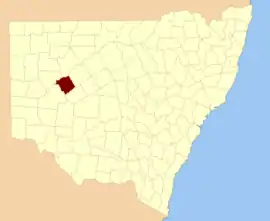
Werunda County

Werunda County is one of the 141 Cadastral divisions of New South Wales. The Darling River is the north-western boundary. It includes Poopelloe Lake, and the area to the east and south-east of Wilcannia.

Werunda
New South Wales
Location in New South Wales
Lands administrative divisions around Werunda:
Young Killara Rankin
Young Werunda Rankin
Livingstone Woore Woore

The name Werunda is believed to be derived from a local Aboriginal word.[1]

Parishes within this county

A full list of parishes found within this county; their current LGA and mapping coordinates to the approximate centre of each location is as follows:

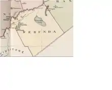
Map of Werunda County, Far west New South Wales from John Sands 1886 Atlas of Australia.
ParishLGACoordinates
CalcooCentral Darling Shire31°39′10″S 143°35′22″E
CaltigeenaaCentral Darling Shire31°34′55″S 143°52′00″E
ChanceCentral Darling Shire31°30′13″S 144°04′53″E
ChirnsideCentral Darling Shire31°57′38″S 143°45′13″E
CoolmaraCentral Darling Shire32°05′22″S 143°49′30″E
CoonavittraCentral Darling Shire31°43′05″S 144°18′23″E
CoonoolcraCentral Darling Shire31°47′18″S 143°35′16″E
CowaryCentral Darling Shireunknown
CultowaCentral Darling Shire31°53′50″S 144°05′40″E
CurranyaleCentral Darling Shireunknown
DonaldCobar Shire31°50′34″S 144°20′34″E
DunoonCentral Darling Shire31°31′41″S 143°37′36″E
GoonalgaaCentral Darling Shire31°45′50″S 143°41′28″E
GreenoughCentral Darling Shire31°34′29″S 144°13′15″E
GunyulkaCentral Darling Shire31°41′55″S 143°29′55″E
KeissCentral Darling Shire31°30′51″S 143°44′26″E
ManaraCentral Darling Shire32°11′23″S 143°50′39″E
MerryCentral Darling Shire31°25′16″S 144°01′55″E
MoiraCentral Darling Shire31°52′54″S 143°54′57″E
MurteeCentral Darling Shire31°36′34″S 143°31′26″E
ParadiseCentral Darling Shire31°59′18″S 143°51′37″E
PoopelloeCentral Darling Shire31°40′14″S 144°09′22″E
RingroseCentral Darling Shire32°02′43″S 144°01′15″E
TalyawalkaCentral Darling Shire31°35′48″S 143°41′28″E
WarwickCobar Shire31°56′19″S 144°01′33″E
WeatherleyCentral Darling Shire31°45′37″S 143°51′16″E
WeeyoolaCentral Darling Shire31°46′05″S 144°09′13″E
WerundaCentral Darling Shire31°29′34″S 143°50′56″E
Wilcannia SouthCentral Darling Shire31°36′12″S 143°23′41″E
WongolarrooCentral Darling Shire31°39′11″S 143°57′20″E
WooreCobar Shireunknown
WoytchuggaCentral Darling Shire31°43′17″S 143°23′13″E
YoreeCentral Darling Shire31°44′13″S 144°01′56″E

References

  1. "Werunda County". Geographical Names Register (GNR) of NSW. Geographical Names Board of New South Wales.
This article is issued from Wikipedia. The text is licensed under Creative Commons - Attribution - Sharealike. Additional terms may apply for the media files.