Westmoreland Street
Westmoreland Street is a street in the southern city-centre of Dublin, Ireland. It is currently a one-way street and part a north-bound section of the R138 road.
 Former EBS building | |
 | |
| Native name | Sráid Westmoreland (Irish) |
|---|---|
| Namesake | John Fane, 10th Earl of Westmorland |
| Length | 220 m (720 ft) |
| Width | 29 metres (95 ft) |
| Location | Dublin, Ireland |
| Postal code | D02 |
| Coordinates | 53°20′44″N 6°15′33″W |
| north end | Aston Quay, O'Connell Bridge |
| south end | College Green |
| Other | |
| Known for | restaurants |
Location
It is one of the two broad avenues - along with D'Olier Street - that converge at their northern ends at O'Connell Bridge over the River Liffey.[1] Westmoreland Street links the bridge to Trinity College at College Green at its southern end, from where traffic diverges between Grafton Street to the south and Dame Street to the west. Westmoreland Street also constitutes the eastern border of Temple Bar.
History
The street is named after John Fane, 10th Earl of Westmorland, who was Lord Lieutenant of Ireland from 1789 to 1794.[2]
Architecture
%252C_Dublin_City%252C_Co._Dublin_(31954425144).jpg.webp)
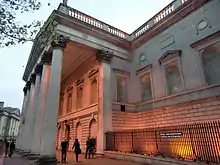
One of the dominant buildings on the street is the former Educational Chambers on the corner of Fleet Street. The original building and facade was significantly altered with a design by architect Sam Stephenson in the early 1970s for EBS. The terracotta facade was demolished and replaced with dark mirror glass which was dubbed a "diabolical black box" by a city councillor at the time it was constructed. The EBS had also acquired three adjoining buildings, the Paradiso restaurant, the main office of The Irish Times, and Graham's pharmacy with plans to demolish these and replicate the dark glass treatment. However, the planers insisted on solid granite elements to this side of the facade, which rendered the whole scheme lop-sided. The facade of the former Paradiso, an art noveau design, was retained within the centre of the redevelopment and houses the building's atrium.[3]
Luas
Luas Green Line | |||||||||||||||||||||||||||||||||||||||||||||||||||||||||||||||||||||||||||||||||||||||||||||||||||||||||||||||||||||||||||||||||||||||||||||||||||||||||||||||||||||||||||||||||||||||||||||||||||||||||||||||||||||||||||||||||||||||||||||||||||||||||||||||||||||||||||||||||||||||||||||||||||||||||||||||||||||||||||||||||||||||||||||||||||||||||||||||||||||||||||||||||||
|---|---|---|---|---|---|---|---|---|---|---|---|---|---|---|---|---|---|---|---|---|---|---|---|---|---|---|---|---|---|---|---|---|---|---|---|---|---|---|---|---|---|---|---|---|---|---|---|---|---|---|---|---|---|---|---|---|---|---|---|---|---|---|---|---|---|---|---|---|---|---|---|---|---|---|---|---|---|---|---|---|---|---|---|---|---|---|---|---|---|---|---|---|---|---|---|---|---|---|---|---|---|---|---|---|---|---|---|---|---|---|---|---|---|---|---|---|---|---|---|---|---|---|---|---|---|---|---|---|---|---|---|---|---|---|---|---|---|---|---|---|---|---|---|---|---|---|---|---|---|---|---|---|---|---|---|---|---|---|---|---|---|---|---|---|---|---|---|---|---|---|---|---|---|---|---|---|---|---|---|---|---|---|---|---|---|---|---|---|---|---|---|---|---|---|---|---|---|---|---|---|---|---|---|---|---|---|---|---|---|---|---|---|---|---|---|---|---|---|---|---|---|---|---|---|---|---|---|---|---|---|---|---|---|---|---|---|---|---|---|---|---|---|---|---|---|---|---|---|---|---|---|---|---|---|---|---|---|---|---|---|---|---|---|---|---|---|---|---|---|---|---|---|---|---|---|---|---|---|---|---|---|---|---|---|---|---|---|---|---|---|---|---|---|---|---|---|---|---|---|---|---|---|---|---|---|---|---|---|---|---|---|---|---|---|---|---|---|---|---|---|---|---|---|---|---|---|---|---|---|---|---|---|---|---|---|---|---|---|---|---|---|---|---|---|---|---|---|---|---|---|---|---|---|---|---|---|---|---|---|---|---|---|---|---|---|---|---|---|---|---|---|
| |||||||||||||||||||||||||||||||||||||||||||||||||||||||||||||||||||||||||||||||||||||||||||||||||||||||||||||||||||||||||||||||||||||||||||||||||||||||||||||||||||||||||||||||||||||||||||||||||||||||||||||||||||||||||||||||||||||||||||||||||||||||||||||||||||||||||||||||||||||||||||||||||||||||||||||||||||||||||||||||||||||||||||||||||||||||||||||||||||||||||||||||||||
Westmoreland Luas stop is on the Green Line (northbound only). This line connects with the Red line and runs from Broombridge in North Dublin and Bride's Glen. Construction started in June 2013 with services beginning in December 2017.[4][5]
References
Notes
- Christine Casey. Dublin: The City Within the Grand and Royal Canals and the Circular Road, with the Phoenix Park. Yale University Press, 2006. ISBN 978-0-300-10923-8; pp. 420–424
- Bardon, Carol and Jonathan (1988). If Ever You Go to Dublin Town. Belfast: The Blackstaff Press. p. 98. ISBN 0-85640-397-0.
- McDonald 1985, p. 176.
- "Green light given to Luas link-up, first passengers 2017". RTÉ. Archived from the original on 5 August 2012. Retrieved 5 August 2012.
- "Taoiseach launches new Luas Cross City service in Dublin". RTÉ. 9 December 2017. Retrieved 9 December 2017.
Sources
- McDonald, Frank (1985). The Destruction of Dublin. Gill and MacMillan. ISBN 0-7171-1386-8.CS1 maint: ref=harv (link)