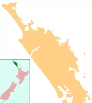
Whau Valley
Whau Valley is a suburb of Whangārei, in Northland Region, New Zealand. State Highway 1 runs through it.[1] The valley was named for the whau trees which grew there in the 1850s.[2]
Whau Valley | |
|---|---|
 Whau Valley | |
| Coordinates: 35°41′55″S 174°18′46″E | |
| Country | New Zealand |
| Region | Northland Region |
| District | Whangarei District |
| Population (2018) | |
| • Total | 2,799 |
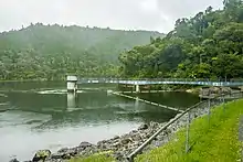
At the end of the 4 km long Whau Valley Road is the principal water reservoir for Whangārei City, created by the Whau Valley Earth Dam. The reservoir is stocked with rainbow and brown trout.[3][4]
History
Some of the early settlers in what was then called Whauwhau Valley were William Hawken and his family, who arrived in 1859, and John MacDonald and his family, in 1860. The MacDonald family was part of the group of people from Nova Scotia who settled in the Whangārei area.[5]
Coal was discovered in the Whauwhau Valley in the 1860s. Henry Walton and William Grahame took a 99 lease on the land and developed a mine. A wooden tramway was built from the mine to the Hātea River so coal wagons could be pulled by horses to be loaded onto ships. The railway line between Kamo and Whangārei, opened in 1882, replaced the tramway. Output of the mine was 45,359 long tons (46,087 t) by 1885.[6]
Demographics
| Year | Pop. | ±% p.a. |
|---|---|---|
| 2006 | 2,601 | — |
| 2013 | 2,538 | −0.35% |
| 2018 | 2,799 | +1.98% |
| Source: [7] | ||
Whau Valley had a population of 2,799 at the 2018 New Zealand census, an increase of 261 people (10.3%) since the 2013 census, and an increase of 198 people (7.6%) since the 2006 census. There were 1,044 households. There were 1,308 males and 1,491 females, giving a sex ratio of 0.88 males per female. Of the total population, 510 people (18.2%) were aged up to 15 years, 480 (17.1%) were 15 to 29, 1,140 (40.7%) were 30 to 64, and 669 (23.9%) were 65 or older. Figures may not add up to the total due to rounding.
Ethnicities were 77.5% European/Pākehā, 26.2% Māori, 3.8% Pacific peoples, 7.3% Asian, and 2.5% other ethnicities. People may identify with more than one ethnicity.
The percentage of people born overseas was 18.6, compared with 27.1% nationally.
Although some people objected to giving their religion, 45.9% had no religion, 41.7% were Christian, and 4.2% had other religions.
Of those at least 15 years old, 411 (18.0%) people had a bachelor or higher degree, and 495 (21.6%) people had no formal qualifications. The median income was $25,500. The employment status of those at least 15 was that 972 (42.5%) people were employed full-time, 315 (13.8%) were part-time, and 120 (5.2%) were unemployed.[7]
Education
Whau Valley School is a contributing primary (years 1-6) school with a roll of 257 students as of March 2020.[8][9]
St Francis Xavier School is a Catholic contributing primary (years 1-6) school with a roll of 481 students as of March 2020.[8][10]
Whangarei Adventist Christian School is a full primary (years 1-8) school with a roll of 34 students as of March 2020.[8][11]
All these schools are coeducational. St Francis Xavier and Whangarei Adventist schools are state integrated.
Notes
- Roger Smith, GeographX (2005). The Geographic Atlas of New Zealand. Robbie Burton. pp. map 24. ISBN 1-877333-20-4.
- Pickmere, Nancy Preece (1986). Whangarei: The Founding Years. p. 70.
- Parkes, W. F. (1992). Guide to Whangarei City and District. p. 54. ISBN 0-473-01639-7.
- "Northland Fishing". Fish & Game New Zealand. Retrieved 2008-05-08.
- Pickmere, 69-70
- Pickmere, pp 56, 144
- "Statistical area 1 dataset for 2018 Census". Statistics New Zealand. March 2020. Whau Valley (106100). 2018 Census place summary: Whau Valley
- "New Zealand Schools Directory". New Zealand Ministry of Education. Retrieved 26 April 2020.
- Education Counts: Whau Valley School
- Education Counts: St Francis Xavier School
- Education Counts: Whangarei Adventist Christian School