White Butte, Saskatchewan
White Butte is the area east of Regina, Saskatchewan that contains the communities of White City, Pilot Butte, Balgonie, Edenwold, and the surrounding farm area and rural municipality. As of 2016, White Butte has a total population of 11,724.[1] If White Butte were a city, it would be the 9th largest city in Saskatchewan, behind the Saskatchewan half of Lloydminster (11,765) and ahead of Estevan (11,483).[1]
White Butte | |
|---|---|
Area | |
 White Butte Location of White Butte  White Butte White Butte (Canada) | |
| Coordinates: 50°28′N 104°25′W | |
| Country | Canada |
| Province | Saskatchewan |
| Area First Settled | 1882 |
| Area | |
| • Total | 897.55 km2 (346.55 sq mi) |
| Population (2016) | |
| • Total | 11,724 (9th) |
| Time zone | UTC−06:00 (CST) |
| Area code(s) | 306, 639 |
The name dates back to 1982 when The White Butte Ski Trails first opened in the area,[2] since then the name has been used a lot for businesses and groups in the area such as the White Butte RCMP detachment, the White Butte Pharmacy, and White Butte Minor Ball Association.
History
The Prairie Indians inhabited the area for many years before any European settlement. Aboriginal people, who camped near Boggy Creek, used the Butte in Pilot Butte as a lookout and signal point.
European settlement in the area can be traced back to the 1840s. With the construction of the railway through the region in 1882, the towns of Pilot Butte and Balgonie were founded. In the following years, settlers began farming in the district and the two towns developed.[3]
The post office in Balgonie was founded in 1883, and the settlement became a village in 1903 and a town in 1907. Pilot Butte followed this path when it became a town in 1913. At the beginning of World War I, the towns were of substantial size. The war had a harmful effect on the towns, however, as Pilot Butte was disbanded in 1923 because of the loss of residents. Balgonie also suffered as the town's population plummeted in the 1930s and 1940s.[4]
In the late 1950s, the Trans-Canada Highway was completed and living in Pilot Butte and Balgonie began to become a popular option for those who wanted to commute to work in the city. Pilot Butte re-acquired village status in 1963 and grew substantially, becoming a town in 1979.[4]
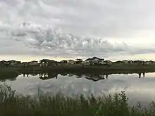
By this point, the community of White City had been formed and was growing as quickly as Pilot Butte and Balgonie. White City acquired town status in 2000 and it passed Pilot Butte in population in 2011, becoming the largest town in White Butte.
All three towns in White Butte have experienced substantial growth in the past ten years.
Towns
White City
Full article: White City, Saskatchewan
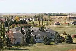
White City, named after White City, London,[5] is a town in Saskatchewan situated at the intersection of the Trans-Canada Highway and Highway 48. The town is primarily populated by people who commute to work in Regina. White City was founded in 1958 by Pilot Butte resident Johnston Lipsett and became a hamlet in 1958, a village in 1967 and a town in 2000. The town's population in 2016 was 3,099, a 63% increase from 2011,[1] making it the largest town in White Butte.
Pilot Butte
Full article: Pilot Butte, Saskatchewan
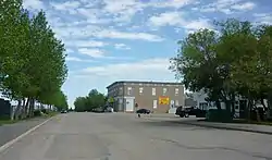
Pilot Butte, meaning "lookout point", is the 29th largest community in Saskatchewan located between Highway 46 and the Trans-Canada Highway. The town was settled in 1882. Pilot Butte's early development was more substantial than neighbouring towns thanks to the town's brick plants, along with its sand and gravel deposits. In 1995, the Pilot Butte Storm destroyed much of the town. In recent years, the population and size of Pilot Butte has begun growing at a high rate.[3] The town's population was 2,183 as of 2016, an 18% growth since 2011,[1] making it the second largest town in White Butte.
Balgonie
Full article: Balgonie
Balgonie, named after Balgonie Castle in Scotland,[4] is a town in Saskatchewan situated at the intersection of the Trans-Canada Highway, Highway 46, and Highway 10. The community was settled in 1882, became a village in 1903, and was incorporated as a town in 1907. Balgonie is home to Greenall High School, where students from White Butte go to high school. The town's population was 1,765 as of 2016, an 8.3% growth since 2011,[1] making it the third largest town in White Butte.
Edenwold
Full article: Edenwold
Edenwold, named after the Garden of Eden,[6] is a village in Saskatchewan located on highways 364 and 640. Edenwold has the same name as the rural municipality that surrounds it. The village had a population of 233 in 2016, a 2.3% decrease from 2011,[1] making it the only part of White Butte that is losing population.
References
- Government of Canada, Statistics Canada (2017-02-08). "Population and Dwelling Count Highlight Tables, 2016 Census". www12.statcan.gc.ca. Retrieved 2019-05-12.
- "Regina Ski Club | The Story of White Butte". reginaskiclub.com. Retrieved 2016-09-14.
- The Canadian Encyclopedia. "Pilot Butte". Retrieved 2013-11-26.
- McLennan, David (2008). Our Town: Saskatchewan Communities from Abbey to Zenon Park. Regina, Saskatchewan: Canadian Plains Research Center, University of Regina. pp. 19–20. ISBN 978-0-88977-209-0. Archived from the original on 2010-04-10.
- Barry, Bill (September 2005). Geographic Names of Saskatchewan. Regina, Saskatchewan: People Places Publishing, Ltd. p. 453. ISBN 1-897010-19-2.
- "Edenwold No. 158", Sask biz, Government of Saskatchewan, retrieved 2007-12-29